The Freshwater Mussels (Unionoida) of the World (and other less consequential bivalves)
FM(U)otW(aolcb) is the web version of the MUSSEL Project Database. Follow the links to browse the data or use the custom Google search field. Either way, you win!
Search the database pages:
Bivalvia | ... | Unionoidea | Unionidae | Unioninae | Anodontini | Anodontina | Anodonta species Anodonta cygnea (Linnaeus, 1758): specimens
278 available nominal species synonyms (417 total synonyms) Recent Taxonomic OpinionsAnodonta cygnea — Graf (2007), Graf & Cummings (2007), Graf & Cummings (2007), Zanatta et al. (2007), Taylor et al. (2007), ... Wang et al. (2025), Campbell & Lydeard (2026), Wu et al. (2026), Prie et al. (2026), Wu et al. (2026)
Anodonta cygnaea [sic] — Dhora (2009)
Anodonta stagnalis — Kantor et al. (2010), Mezhzherin et al. (2014)
Anodonta zellensis zellensis — Kantor et al. (2010)
Colletopterum oblongum — Kantor et al. (2010)
Anodonta lucasi — IUCN (2010), Van Damme et al. (2010)
Anodonta parmata — Kantor et al. (2010)
Anodonta pallaryi — IUCN (2010), Van Damme et al. (2010)
Anodonta zellensis micheli — Kantor et al. (2010)
Anodonta zellensis — Mezhzherin et al. (2014)
Anodonta (s.s.) cygnea — Vinarski & Kantor (2016)
Anodonta (s.s.) stagnalis — Vinarski & Kantor (2016)
Anodonta (s.s.) zellensis — Vinarski & Kantor (2016)
Anodonta anatina — Gomes-dos-Santos et al. (2019)
Anodonta cygnea cygnea — Bogatov (2022)
Anodonta cygnea stagnalis — Bogatov (2022)
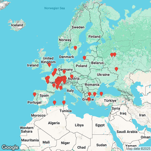
Anodonta cygnea zellensis — Bogatov (2022) RangeEurope and northern Africa. Map of Georeferenced Specimens

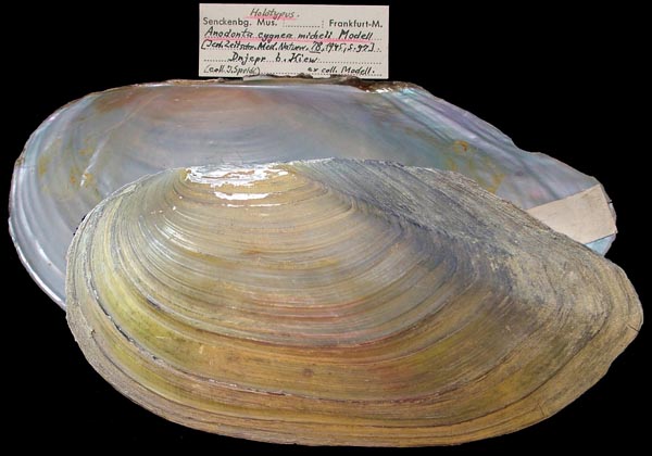
SMF_5168
[no locality data. Probably the same as SMF 4979] possibly: Teich b. Schönfeld nahe Kassel [Germany]
| 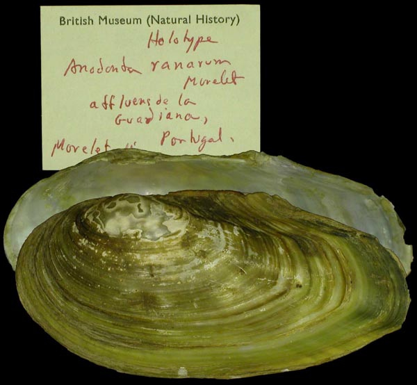
BMNH_93-2-4-1737
afflu. de la Guardiana, Portugal
| 
SMF_79016
Dnjepr [Dniepr], b. Kiew [Kiev] [Ukraine]
| 
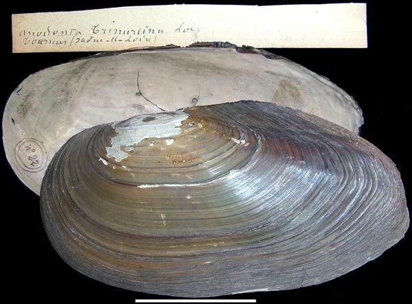
LS_257
Europe, a l’embouchure des fleuves
| 
SMF_5140
Lache b. Platschütz b. Allenburg [Germany]
| 
SMF_5145
Plattensee [Lake Balaton] Ungarn [Hungary]
| 
SMF_5157
Villeneuve, Genfer See [Lake Geneva] [Switzerland]
|
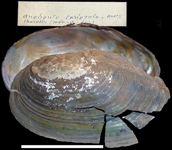
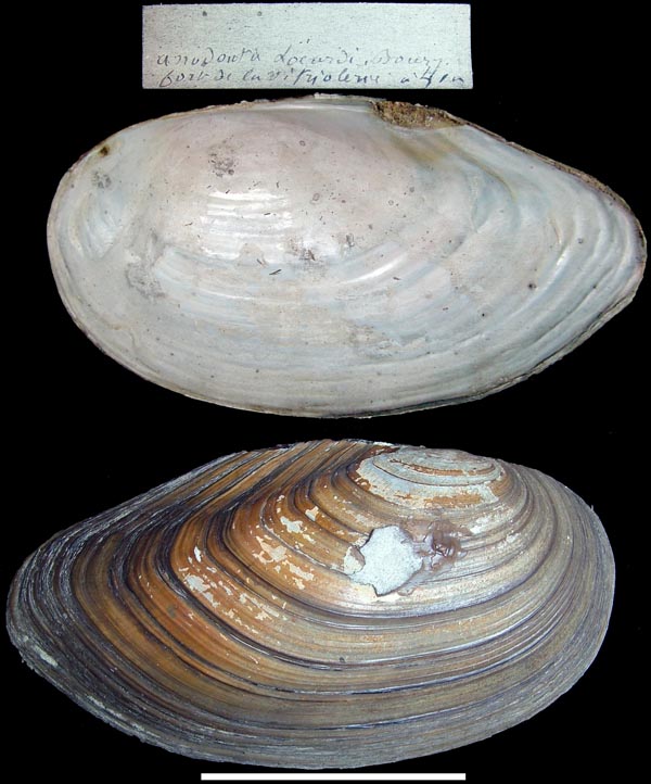
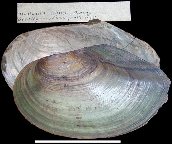
MNHN_MP_2205. [illegible] (Ain) MNHN_MP_2043. [illegible] Versailles MNHN_MP_2209. [locality illegible] MNHN_MP_2291. [locality illegible] MNHN_MP_2042. Callebasse, près Gannat (Allier) MNHN_MP_2064. Coimbre MNHN_MP_2048. du Rhône MNHN_MP_2207. Étang de la Faye (Charente) MNHN_MP_2208. Étang de la Faye (Charente) MNHN_MP_2213. Foja [Portugal] MNHN_MP_2100. Foret-de-Concise près Laval (Mayenne) MNHN_MP_2056. La Loire “infer” [illegible] (Loire) MNHN_MP_2290. La Louet [illegible] MNHN_MP_2098. La Saône, à Trévoux MNHN_MP_2304. La Vienne, à Poitiers MNHN_MP_2071. Lac St-Clair [illegible] MNHN_MP_2212. Lagoa do Ervedal [Portugal ?] INHS_990. Lake Kalterer, Südtirol, Kaltern, Trentino-Alto Adige/Südtirol, Italy MNHN_MP_2206. Le Né (Charente) INHS_19856. Lubrzanka Creek, 6 km S Kielce, Świętokrzyskie Voivodeship, Poland MNHN_MP_2055. Moulins (Allier) INHS_21428. Nieuwe Merwede, S of Dordrecht, "Kop van Land", South Holland, Netherlands MNHN_MP_2037. Penmur (Morbihan) MNHN_MP_2039. Penmur (Morbihan) [illegible] INHS_21798. Pest, Budapest, Central Hungary, Hungary INHS_48948. Segre River, Sant Llorenc de Montgai, Catalonia, Spain MNHN_MP_2214. Silveiro près Fermantelles [Portugal] SMF_4979. Teich b. Schönfeld nahe Kassel [Germany] MNHN_MP_2210. vallas do Rol, Mondego [Portugal]
AlgeriaBMNH_MP_366. La Calle
EnglandINHS_23639. New Bedford River, Sutton Gault, 11 km from Ely, Cambridgeshire, East of England, England
FranceMNHN_MP_2204. [illegible] (Isère) MNHN_MP_2178. [illegible] (Maine-et-Loire) MNHN_MP_2292. [illegible] (Maine-et-Loire) MNHN_22105. [illegible] lac de Malpas (Doubs)? MNHN_MP_2047. [illegible] Pontoise (Seine-et-Oise) MNHN_MP_2099. Angers (Maine-et-Loire) MNHN_MP_2108. Angers (Maine-et-Loire) / Frejus (Var) MNHN_MP_2211. Arles MNHN_22259. Avignon (Vaucluse) MNHN_MP_2150. Espalion (Aveyron) MNHN_22452. fort des Hirondelles à Lyon MNHN_22409. fosses de la Mouche à Lyon MNHN_22313. fossés des forts de la Mouche à Lyon MNHN_MP_2046. fossés des forts de la Vitriolerie INHS_21797. France MNHN_MP_2006. Garonne, près Fréjus MNHN_22260. Irigny (Rhône) MNHN_MP_2041. La Jarrie MNHN_MP_2293. La Loire à Nantes (Loire-Infereur) MNHN_22411. La Saône à Neuville (Saône) MNHN_MP_2179. La Seine, St-Ouen MNHN_22104. lac d’Aiguebelette (Savoie) MNHN_22103. lac d’Annecy, Savoie MNHN_22103B. lac d’Annecy, Savoie MNHN_MP_2215. Lac de Paladru [France] MNHN_MP_2070. lac du Bourget (Savoie) MNHN_MP_2008. le canal de Givors, à Givors, Rhône MNHN_22261. le canal de Mons à Condé dans le département du Nord MNHN_22407B. Le Drageon (Doubs) MNHN_22407C. Le Drageon (Jura) MNHN_22407. Le Drugeon (Jura) MNHN_22410. Le Rhône au confluence de la [illegible] MNHN_MP_2177. le Rhône, à la Mulatière (Rhône) MNHN_22408. Le Rhône, au confluence, Lyon MNHN_22453. Rhône au confluent, à Lyon MNHN_MP_2040. Saint-Laurent-d’Ain (Ain) MNHN_22590. Tournus (Saône-et-Loire)
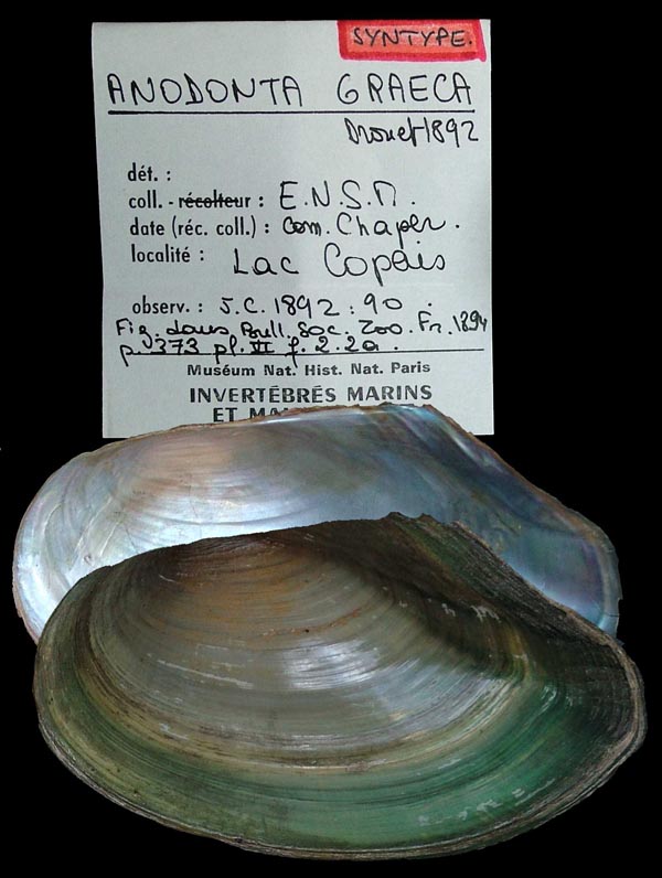
GreeceMNHN_MP_0189. Lake Beschik, Macedonia
HungaryINHS_21799. Anglia, Hungary
SwitzerlandINHS_21800. Aargau [= Kanton Aargau], Switzerland MNHN_22413. lac de Morat (Suisse) MNHN_22412. lac de Neuchâtel (Suisse) MNHN_MP_2072. Lac Morat (Suisee) Georeferenced Genbank Vouchers
AustriaMp_2654_Acyg. (16S: AF232799, COI: AF232824, go to Genbank) Lake Obertrumersee Salzburgh, Austria.
GermanySMF_360684. (16S: OK055694, 28S: OK077679, COI: OK050304, go to Genbank) Großer Woog, Darmstadt (49.87345, 8.6709).
PortugalMp_3580_AcygnPF2.8. (COI: EF571398, go to Genbank) Pateira de Fermentelos, Vouga Basin, Portugal. CIIMAR_AC6. (SRA: SRX5278580, go to Genbank) Portugal: Fermentelos, Fermentelos Lake, Vouga (40.573983 N 8.51463600 W).
RussiaRMBH_biv_207_1. (16S: MK574311, 28S: MK574450, COI: MK034159, go to Genbank) Russia: European part, Kaliningrad Region, Lebedinoye Lake (54.7938° N, 20.5286° E), Baltic Sea drainage. RMBH_biv_207_2. (16S: MK574312, 28S: MK574451, COI: MK574184, go to Genbank) ditto. RMBH_biv_207_3. (16S: MK574313, 28S: MK574452, COI: MK034160, go to Genbank) ditto. RMBH_biv_204_1. (16S: MK574307, 28S: MK574446, COI: MK034157, go to Genbank) Russia: European part, Moscow Region, Lake Glubokoye (55.7519°N, 36.5102°E), Volga Basin, Caspian Sea drainage. RMBH_biv_204_3. (16S: MK574308, 28S: MK574447, COI: MK034158, go to Genbank) ditto. RMBH_biv_204_6. (16S: MK574309, 28S: MK574448, COI: MK574182, go to Genbank) ditto. RMBH_biv_204_7. (16S: MK574310, 28S: MK574449, COI: MK574183, go to Genbank) ditto. RMBH_biv_194_1. (16S: MK574305, 28S: MK574444, COI: MK034153, go to Genbank) Russia: European part, Moskow Region, Medvezhii Lakes (55.8650° N, 38.0010° E), Volga Basin, Caspian Sea drainage. RMBH_biv_194_2. (16S: MK574306, 28S: MK574445, COI: MK034154, go to Genbank) ditto. RMBH_biv_769_1. (COI: MT027890, go to Genbank) Russia: European part, Voronezh Region, Tikhaya Sosna River (50.8570° N, 39.0790° E), Don Basin, Azov Sea drainage.
SwedenNRM_42772-M094. (16S: DQ060164, 18S, ITS1: DQ060186, COI: DQ060170, go to Genbank) Sweden: Sommen lake.
SwitzerlandNMBE_565034. (28S: OK077597, COI: OK050215, go to Genbank) Ceresio, Agno Camping (45.99222, 8.89857). NMBE_565035. (16S: OK055611, 28S: OK077598, COI: OK050216, go to Genbank) ditto. NMBE_565036. (16S: OK055612, 28S: OK077599, COI: OK050217, go to Genbank) ditto. NMBE_565037. (16S: OK055613, 28S: OK077600, go to Genbank) ditto. NMBE_565818. (16S: OK055653, 28S: OK077638, COI: OK050252, go to Genbank) ditto. NMBE_565041. (16S: OK055617, go to Genbank) Etang sous la Sagne (47.2303, 7.0883). NMBE_565042. (16S: OK055618, go to Genbank) ditto. NMBE_559863. (16S: OK055583, 28S: OK077567, COI: OK050185, go to Genbank) Gouille Marion, Mies (46.3035, 6.1575). NMBE_559864. (16S: OK055584, 28S: OK077568, COI: OK050186, go to Genbank) ditto. NMBE_559865. (16S: OK055585, 28S: OK077569, COI: OK050187, go to Genbank) ditto. NMBE_565043. (16S: OK055619, 28S: OK077604, go to Genbank) Hallwilersee, Beinwil (47.27235, 8.20932). NMBE_565044. (16S: OK055620, 28S: OK077605, go to Genbank) Lac Brenet, Les Charbonnières (46.6672, 6.3172). NMBE_565045. (16S: OK055621, 28S: OK077606, COI: OK050221, go to Genbank) ditto. NMBE_559875. (16S: OK055592, 28S: OK077577, go to Genbank) Lac Neuchâtel, St-Blaise (47.0109, 6.9806). NMBE_566638. (16S: OK055669, go to Genbank) Nussbaumersee, Nussbaumen TG (47.6137, 8.8134). NMBE_566631. (16S: OK055663, 28S: OK077652, COI: OK050270, go to Genbank) Sarnersee, Zollhaus OW (46.8459, 8.2029). NMBE_565068. (16S: OK055641, go to Genbank) Verbano, Tenero Lido (46.1665, 8.8498). NMBE_566632. (16S: OK055664, 28S: OK077653, COI: OK050271, go to Genbank) Vierwaldstättersee, Küssnacht SZ (47.0776, 8.4301). NMBE_566633. (16S: OK055665, 28S: OK077654, COI: OK050272, go to Genbank) ditto. NMBE_565080. (16S: OK055652, 28S: OK077636, COI: OK050251, go to Genbank) Walensee, Unterterzen (47.11356, 9.24982). NMBE_559890. (16S: OK055606, 28S: OK077591, COI: OK050209, go to Genbank) Zugersee, Zug (47.17314, 8.50292).
TurkeyGCMAE_M34_A_1. (16S: MZ518961, 28S: MZ519198, COI: MZ510979, go to Genbank) Turkey: Çamlıca: Maritsa Basin (40.768715, 26.514664). GCMAE_M34_A_2. (16S: MZ518962, 28S: MZ519199, COI: MZ510980, go to Genbank) ditto. CIIMAR_BIV2352. (COI: MZ510965, go to Genbank) Turkey: Taşkısığı: Sakarya Basin (40.865868, 30.405434). CIIMAR_BIV2353. (COI: MZ510966, go to Genbank) ditto. CIIMAR_BIV2354. (16S: MZ518915, 28S: MZ519152, COI: MZ510967, go to Genbank) ditto. CIIMAR_BIV2355. (16S: MZ518916, 28S: MZ519153, COI: MZ510968, go to Genbank) ditto. CIIMAR_BIV2356. (16S: MZ518917, 28S: MZ519154, COI: MZ510969, go to Genbank) ditto. |