| Page last updated
Thu 3 September 2025 |
The Freshwater Mussels (Unionoida) of the World (and other less consequential bivalves)
FM(U)otW(aolcb) is the web version of the MUSSEL Project Database. Follow the links to browse the data or use the custom Google search field. Either way, you win!
Search the database pages:
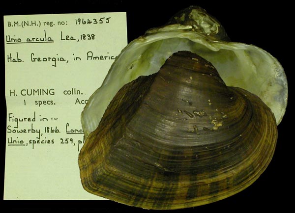
Bivalvia | ... | Unionoidea | Unionidae | Unioninae | Anodontini | Alasmidontina | Alasmidonta species Alasmidonta arcula (Lea, 1838): specimens
1 available nominal species synonym (2 total synonyms) Recent Taxonomic OpinionsAlasmidonta (s.s.) arcula — Graf & Cummings (2007), Williams et al. (2014)
Alasmidonta arcula — Bogan (2010), Cummings & Graf (2010), IUCN (2012), ITIS (2012), Haag (2012), ... FMCS (2021), Whelan et al. (2023), Hopper et al. (2023), Perkins et al. (2025), FMCS (2025)
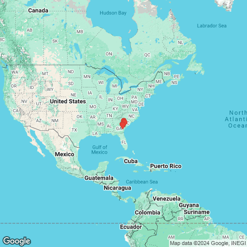
Alasmidonta (Bullella) arcula — Campbell & Lydeard (2026) RangeAltamaha River, Georgia, USA. Map of Georeferenced Specimens
USAGeoreferenced Genbank Vouchers
USAUF_437994.009. (18S, 5.8S, ITS1: ON197369, adenine nucleotide translocase: ON165007, COI: ON157844, ND1: ON164859, go to Genbank) USA, Georgia, Effingham County, Savannah River at base of bluff at mouth of Kennedy Lake (32.4984, -81.23404). UF_439049.9032. (18S, 5.8S, ITS1: ON197378, adenine nucleotide translocase: ON165020, COI: ON157853, go to Genbank) USA, Georgia, Effingham County, Savannah River at RM 54.1, about 4.2 mi. ESE of Clyo (32.46654, -81.19842). UF_438450.001. (18S, 5.8S, ITS1: ON197362, COI: ON157837, ND1: ON164855, go to Genbank) USA, Georgia, Long/Wayne County, Altamaha River at mouth of Floyds Slough, about 2.5 river km upstream of US 301 bridge (31.677931, -81.846881). UF_438439.004. (18S, 5.8S, ITS1: ON197365, adenine nucleotide translocase: ON164997, COI: ON157840, go to Genbank) USA, Georgia, Wayne County, Altamaha River about 1km upstream of Wayne County boat ramp (31.79494, -81.99959). UF_438439.005. (18S, 5.8S, ITS1: ON197366, adenine nucleotide translocase: ON164998, COI: ON157841, go to Genbank) ditto. UF_437999.010. (18S, 5.8S, ITS1: ON197370, adenine nucleotide translocase: ON165008, COI: ON157845, go to Genbank) USA, South Carolina, Allendale County, Savannah River, just above mouth of King Creek (The Gaul on some maps) near RM 109.3 (32.87424, -81.45353). UF_437999.011. (18S, 5.8S, ITS1: ON197371, adenine nucleotide translocase: ON165009, COI: ON157846, ND1: ON164860, go to Genbank) ditto. UF_437999.012. (adenine nucleotide translocase: ON165010, COI: ON157847, ITS1: ON197372, ND1: ON164861, go to Genbank) ditto. UF_437999.013. (18S, 5.8S, ITS1: ON197373, adenine nucleotide translocase: ON165011, COI: ON157848, ND1: ON164862, go to Genbank) ditto. UF_437999.014. (18S, 5.8S, ITS1: ON197374, adenine nucleotide translocase: ON165012, COI: ON157849, ND1: ON164863, go to Genbank) ditto. UF_437999.015. (18S, 5.8S, ITS1: ON197375, adenine nucleotide translocase: ON165013, COI: ON157850, ND1: ON164864, go to Genbank) ditto. UF_438007.016. (18S, 5.8S, ITS1: ON197376, adenine nucleotide translocase: ON165014, COI: ON157851, ND1: ON164865, go to Genbank) USA, South Carolina, Allendale County, Savannah River, just below Cohens Bluff, RM 103.9, about 11 mi. W of Luray (32.84069, -81.42567). UF_438009.017. (adenine nucleotide translocase: ON165015, COI: ON157852, ITS1: ON197377, ND1: ON164866, go to Genbank) USA, South Carolina, Jasper County, Savannah River at lower end of slough at Cutoff 7-A at RM 59.5 (32.51821, -81.2426). |