| Page last updated
Thu 3 September 2025 |
The Freshwater Mussels (Unionoida) of the World (and other less consequential bivalves)
FM(U)otW(aolcb) is the web version of the MUSSEL Project Database. Follow the links to browse the data or use the custom Google search field. Either way, you win!
Search the database pages:
Bivalvia | Unionida | Unionoidea | Unionidae | Ambleminae | Lampsilini | Potamilus species Potamilus inflatus (Lea, 1831): specimens
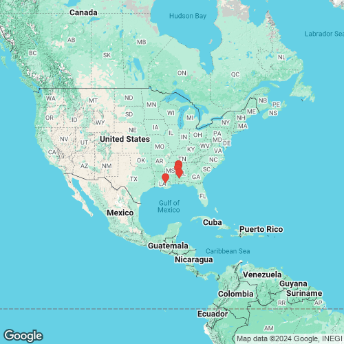
2 available nominal species synonyms (3 total synonyms) Recent Taxonomic OpinionsPotamilus inflatus — Graf & Cummings (2007), Williams et al. (2008), Bogan (2010), Cummings & Graf (2010), ITIS (2012), ... FMCS (2021), Hopper et al. (2023), Hauck et al. (2023), FMCS (2025), Campbell & Lydeard (2026) RangeMobile Basin, eastern Gulf Coastal Plain, USA. Map of Georeferenced Specimens
USAGeoreferenced Genbank Vouchers
USAUF_439131-10456. (28S: MK036120, COI: MK044952, FEM1: MT669774, ITS1, 5.8S: MK036203, ND1: MK045103, UbiA1: MT669747, go to Genbank) Tombigbee River, Mobile drainage (32.5172, -87.8698). UF_439131-10458. (28S: MK036121, COI: MK044953, ITS1, 5.8S: MK036204, ND1: MK045104, SRA: SRX7259537, go to Genbank) USA, Alabama, Marengo/Sumter, Mouth of Foscue Creek/Tombigbee River approximately 0.5 miles upstream of Demopolis L and D- Dredge site (USCG/US Corps Facilities) (32.51715, -87.86976). UF_439131-PinfMob001. (COI: MT662002, FEM1: MT669773, ITS1: MT661768, ND1: MT669647, UbiA1: MT669746, go to Genbank) ditto. UF_439131-PinfMob003. (COI: MT662003, FEM1: MT669775, ITS1, 5.8S: MT661769, ND1: MT669648, UbiA1: MT669748, go to Genbank) ditto. UF_439131-PinfMob005. (COI: MT662004, FEM1: MT669776, ITS1, 5.8S: MT661770, ND1: MT669649, UbiA1: MT669749, go to Genbank) ditto. UF_439131-PinfMob006. (COI: MT662005, FEM1: MT669777, ITS1: MT661771, ND1: MT669650, UbiA1: MT669750, go to Genbank) ditto. UF_439513-PinfMob017. (COI: MT662017, FEM1: MT669793, ITS1, 5.8S: MT661788, ND1: MT669662, UbiA1: MT669766, go to Genbank) USA, Alabama, Tuscaloosa County, Black Warrior River between US Hwy 82 and AL Hwy 69 bridge (33.22022, -87.55038). UF_439513-PinfMob018. (COI: MT662018, FEM1: MT669794, ITS1, 5.8S: MT661789, ND1: MT669663, UbiA1: MT669767, go to Genbank) ditto. UF_439514-PinfMob019. (COI: MT662012, FEM1: MT669788, ITS1, 5.8S: MT661783, ND1: MT669657, UbiA1: MT669761, go to Genbank) USA, Alabama, Tuscaloosa County, Black Warrior River near Moundville Archaeological Park (33.00965, -87.63561). UF_439514-PinfMob020. (COI: MT662013, FEM1: MT669789, ITS1, 5.8S: MT661784, ND1: MT669658, UbiA1: MT669762, go to Genbank) ditto. UF_439514-PinfMob021. (COI: MT662014, FEM1: MT669790, ITS1, 5.8S: MT661785, ND1: MT669659, UbiA1: MT669763, go to Genbank) ditto. UF_439514-PinfMob022. (COI: MT662015, FEM1: MT669791, ITS1: MT661786, ND1: MT669660, UbiA1: MT669764, go to Genbank) ditto. UF_439514-PinfMob023. (COI: MT662016, FEM1: MT669792, ITS1: MT661787, ND1: MT669661, UbiA1: MT669765, go to Genbank) ditto. UF_439531-PinfAmi012. (COI: MT662008, FEM1: MT669781, ITS1, 5.8S: MT661776, ND1: MT669653, UbiA1: MT669754, go to Genbank) USA, Louisiana, Livingston Parish, Amite River (30.38867, -90.96779). UF_439530-PinfAmi010. (COI: MT662006, FEM1: MT669779, ITS1: MT661774, ND1: MT669651, UbiA1: MT669752, go to Genbank) USA, Louisiana, Livingston Parish, Amite River (30.40467, -90.95933). UF_439530-PinfAmi011. (COI: MT662007, FEM1: MT669780, ITS1: MT661775, ND1: MT669652, UbiA1: MT669753, go to Genbank) ditto. UF_439532-PinfAmi013. (COI: MT662009, FEM1: MT669782, ITS1: MT661777, ND1: MT669654, UbiA1: MT669755, go to Genbank) USA, Louisiana, Livingston Parish, Amite River (30.41718, -90.9643). UF_439532-PinfAmi014. (COI: MT662010, FEM1: MT669783, ITS1, 5.8S: MT661778, ND1: MT669655, UbiA1: MT669756, go to Genbank) ditto. UF_439533-PinfAmi015. (COI: MT662011, FEM1: MT669784, ITS1: MT661779, ND1: MT669656, UbiA1: MT669757, go to Genbank) USA, Louisiana, Livingston Parish, Amite River (30.42666, -90.98211). |