The Freshwater Mussels (Unionoida) of the World (and other less consequential bivalves)
FM(U)otW(aolcb) is the web version of the MUSSEL Project Database. Follow the links to browse the data or use the custom Google search field. Either way, you win!
Search the database pages:
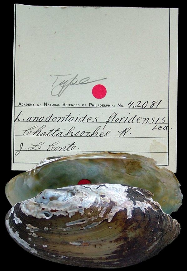
Bivalvia | Unionida | Unionoidea | Unionidae | Ambleminae | Lampsilini | Lampsilis species Lampsilis floridensis (Lea, 1852): specimens
1 available nominal species synonym Recent Taxonomic OpinionsLampsilis floridensis — Williams et al. (2008), Bogan (2010), Williams et al. (2011), Haag (2012), Williams et al. (2014), Williams et al. (2017), Keogh & Simons (2019), Graf & Cummings (2021), FMCS (2021), Keogh et al. (2021), Hopper et al. (2023), FMCS (2025)
Lampsilis teres — Watters et al. (2009)
Simpsonunio floridensis — Campbell & Lydeard (2026) RangeIn the eastern Gulf Coastal Plain, from the Escambia east into peninsular Florida, USA. Map of Georeferenced Specimens
USAGeoreferenced Genbank Vouchers
USAUF_438454 (LfloSuw022). (COI: MW143387, ND1: MW172855, go to Genbank) Boat basin off Suwannee River in Original Suwannee River Campground @ 1 mi. W of Fanning Springs (29.58891, -82.94239). UF_438694 (LfloChi001). (COI: MW143352, go to Genbank) Chipola River about 0.75 miles above confluence with Apalachicola River (30.0117, -85.1061). UF_438535 (LfloCho016). (COI: MW143355, go to Genbank) Choctawhatchee River ~1.5 miles upstream of FL Hwy 20 bridge; sample taken in bend of river below mouth of slough on RDB (30.47335, -85.88662). UF_438535 (LfloCho017). (COI: MW143356, go to Genbank) ditto. UF_438535 (LfloCho018). (COI: MW143357, go to Genbank) ditto. UF_438510 (LfloCho049). (COI: MW143360, go to Genbank) Cowford Lake off Choctawhatchee River, below FL Hwy 20 bridge (30.43643, -85.9012). UF_438510 (LfloCho051). (COI: MW143361, go to Genbank) ditto. JFBM_22437_1 (SK16073). (COI: MK391861, ITS1, 5.8S: MK391914, ND1: MW172846, go to Genbank) Flint River at SR 37 Boat Landing in Newton, Baker/Mitchell Co. GA (31.30919, -84.33491). JFBM_22437_10 (SK16082). (COI: MK391870, ND1: MW172854, go to Genbank) ditto. JFBM_22437_2 (SK16074). (COI: MK391862, ITS1, 5.8S: MK391915, ND1: MW172847, go to Genbank) ditto. JFBM_22437_3 (SK16075). (COI: MK391863, ND1: MW172848, go to Genbank) ditto. JFBM_22437_4 (SK16076). (COI: MK391864, ND1: MW172849, go to Genbank) ditto. JFBM_22437_5 (SK16077). (COI: MK391865, ND1: MW172850, go to Genbank) ditto. JFBM_22437_6 (SK16078). (COI: MK391866, ND1: MW172851, go to Genbank) ditto. JFBM_22437_7 (SK16079). (COI: MK391867, ND1: MW172852, go to Genbank) ditto. JFBM_22437_8 (SK16080). (COI: MK391868, go to Genbank) ditto. JFBM_22437_9 (SK16081). (COI: MK391869, ND1: MW172853, go to Genbank) ditto. UF_438733 (LfloFli007). (COI: MW143369, go to Genbank) Flint River on GA Highway 37, south side of Newton (31.306961, -84.338597). UF_438733 (LfloFli010). (COI: MW143370, go to Genbank) ditto. UF_438335 (LfloOch039). (COI: MW143372, go to Genbank) Lake Talquin about 3.9 km SSE of Midway (30.4607, -84.44583). UF_438335 (LfloOch040). (COI: MW143373, go to Genbank) ditto. UF_438346 (LfloOch042). (COI: MW143374, go to Genbank) Ochlockonee River about 150 m upstream of US 90 bridge (30.47529, -84.40481). UF_438346 (LfloOch043). (COI: MW143375, go to Genbank) ditto. UF_438346 (LfloOch044). (COI: MW143376, go to Genbank) ditto. UF_438346 (LfloOch045). (COI: MW143377, go to Genbank) ditto. UF_438346 (LfloOch046). (COI: MW143378, go to Genbank) ditto. UF_438346 (LfloOch047). (COI: MW143379, go to Genbank) ditto. UF_438346 (LfloOch048). (COI: MW143380, go to Genbank) ditto. UF_441028 (LfloOch052). (COI: MW143381, go to Genbank) Ochlockonee River about 4.0 RM downstream of Jackson Bluff Dam (30.36034, -84.68476). UF_441028 (LfloOch053). (COI: MW143382, go to Genbank) ditto. UF_441028 (LfloOch054). (COI: MW143383, go to Genbank) ditto. UF_441028 (LfloOch055). (COI: MW143384, go to Genbank) ditto. UF_439011 (LfloOch076). (COI: MW143385, go to Genbank) Ochlockonee River at mouth of High Hill Creek, about 2 km below mouth of Telogia Creek (30.25497, -84.72145). UF_439011 (LfloOch077). (COI: MW143386, go to Genbank) ditto. UF_438768 (LfloOch005). (COI: MW143371, go to Genbank) Ochlockonee River, 1 air mile upstream of US Highway 27 bridge - river access gained through SBA communication combination lock 4722 (30.56719, -84.37989). UF_441067 (LfloCho056). (COI: MW143362, go to Genbank) Pea River at confluence of Choctawhatchee River in Geneva (31.02185, -85.85833). UF_441067 (LfloCho057). (COI: MW143363, go to Genbank) ditto. UF_441067 (LfloCho058). (COI: MW143364, go to Genbank) ditto. UF_441067 (LfloCho059). (COI: MW143365, go to Genbank) ditto. UF_441067 (LfloCho060). (COI: MW143366, go to Genbank) ditto. UF_441067 (LfloCho061). (COI: MW143367, go to Genbank) ditto. UF_441067 (LfloCho062). (COI: MW143368, go to Genbank) ditto. UF_438344 (LfloCho020). (COI: MW143358, go to Genbank) Pea River on AL Hwy 87 just N of the FL state line (30.99735, -85.99712). UF_438344 (LfloCho021). (COI: MW143359, go to Genbank) ditto. UF_439370 (LterEsc138). (COI: MW143399, go to Genbank) Point A Lake near large island. Mussels collected during draw down (31.37259, -86.517135). UF_439370 (LterEsc139). (COI: MW143400, go to Genbank) ditto. UF_439370 (LterEsc140). (COI: MW143401, go to Genbank) ditto. UF_439370 (LterEsc141). (COI: MW143402, go to Genbank) ditto. UF_439370 (LterEsc142). (COI: MW143403, go to Genbank) ditto. UF_439370 (LterEsc143). (COI: MW143404, go to Genbank) ditto. UF_439370 (LterEsc144). (COI: MW143405, go to Genbank) ditto. UF_439370 (LterEsc145). (COI: MW143406, go to Genbank) ditto. UF_439370 (LterEsc146). (COI: MW143407, go to Genbank) ditto. UF_439370 (LterEsc147). (COI: MW143408, go to Genbank) ditto. UF_439370 (LterEsc148). (COI: MW143409, go to Genbank) ditto. UF_438578 (LfloSuw063). (COI: MW143389, ND1: MW172856, go to Genbank) Santa Fe River on State Hwy 121, S of Worthington Springs (29.92199, -82.42658). UF_438578 (LfloSuw064). (COI: MW143390, ND1: MW172857, go to Genbank) ditto. UF_438578 (LfloSuw065). (COI: MW143391, ND1: MW172858, go to Genbank) ditto. UF_438578 (LfloSuw066). (COI: MW143392, ND1: MW172859, go to Genbank) ditto. UF_438578 (LfloSuw067). (COI: MW143393, ND1: MW172860, go to Genbank) ditto. UF_438578 (LfloSuw068). (COI: MW143394, ND1: MW172861, go to Genbank) ditto. UF_438578 (LfloSuw069). (COI: MW143395, ND1: MW172862, go to Genbank) ditto. UF_438578 (LfloSuw070). (COI: MW143396, ITS1, 5.8S: MW136929, ND1: MW172863, go to Genbank) ditto. UF_438578 (LfloSuw071). (COI: MW143397, ND1: MW172864, go to Genbank) ditto. UF_438517 (LfloWit023). (COI: MW143398, go to Genbank) Silver Lake on Withlacoochee River @ 0.25 miles E (upstream) of I75 (28.577747, -82.217192). UF_438739 (LfloCho011). (COI: MW143353, go to Genbank) Slough on south side of Cowford Lake off Choctawhatchee River below Hwy 20 bridge (30.4321, -85.9103). UF_438739 (LfloCho012). (COI: MW143354, go to Genbank) ditto. UF_441034 (LfloSuw032). (COI: MW143388, go to Genbank) Suwannee River on right descending bank (RDB) just below US27 bridge in Branford (29.9543, -82.93). |