| Page last updated
Thu 3 September 2025 |
The Freshwater Mussels (Unionoida) of the World (and other less consequential bivalves)
FM(U)otW(aolcb) is the web version of the MUSSEL Project Database. Follow the links to browse the data or use the custom Google search field. Either way, you win!
Search the database pages:
Bivalvia | Unionida | Hyrioidea | Hyriidae | Velesunioninae | Lortiella species Lortiella rugata (Sowerby, 1868): specimens
1 available nominal species synonym Recent Taxonomic OpinionsLortiella rugata — Graf & Cummings (2007), Hoeh et al. (2009), Bogan (2010), Walker et al. (2014), Zieritz et al. (2015), Graf & Cummings (2021), Ponder et al. (2025), Campbell & Lydeard (2026)
Lortiella rugatus — Zieritz et al. (2013), Marshall et al. (2014)
Lortiella sp. — Santos-Neto et al. (2016) RangeVictoria and Ord rivers of Western Australia and Northern Territory. Map of Georeferenced Specimens
Australia
AMS_113749
195 km W of Katherine, Victoria R, ca 1.5km upstream from bridge on Victoria Hwy (Shallow water, under rocks in gravel), Northern Territory, Australia [-15.6, 131.117 ± 10 km]
| 
ZMB_MP_0451
Australia
| 
ZMB_MP_0458
Australia
| 
AMNH_61955
Australia
| 
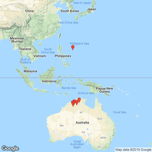
BMNH_44-1-12-7
Australia
| 
BMNH_44-1-12-7
Australia
| 
UMMZ_112701
Australia [SE Asia]
| 
INHS_16214
Katherine River, near the entrance to Katherine River Gorge National Park, Katherine, Northern Territory, Australia
| 
AMS_371676
Victoria R at Coolibah Stn Rd, Northern Territory, Australia [-15.555, 130.963 ± 100 m]
| 
AMS_371676
Victoria R at Coolibah Stn Rd, Northern Territory, Australia [-15.555, 130.963 ± 100 m]
| 
BMNH_57-11-18-28
Victoria River
| 
BMNH_57-11-18-28
Victoria River
| 
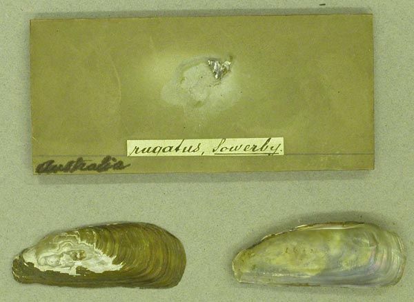
BMNH_41-11-25-58-59
Victoria River, N Australia
| 
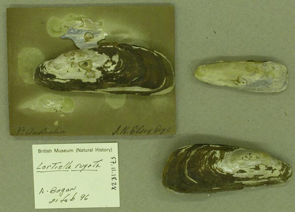
BMNH_MP_367
Victoria River, N. Australia
| 
BMNH_44-1-12-160
Victoria River, N. Australia
| 
BMNH_44-1-12-160
Victoria River, N. Australia
| 
USNM_853936
Victoria River, Norrtern Territory, Australia
|
WAM_S13773. Behn R, East Kimberley, nr Argyle Downs HS, Western Australia, Australia [-16.517, 128.917 > ± 100 km] WAM_S13757. Kununurra, irrigation area, main supply channel, Western Australia, Australia [-15.767, 128.733 ± 1 km] WAM_S13758. Kununurra, irrigation area, main supply channel, Western Australia, Australia [-15.767, 128.733 ± 1 km] WAM_S13759. Kununurra, irrigation area, main supply channel, Western Australia, Australia [-15.767, 128.733 ± 1 km] AMS_427109. Kununurra, Lake Kununurra at Kona caravan Park (In tube-like burrows in mud bank), Western Australia, Australia [-15.794, 128.719 ± 100 m] WAM_S13756. Ord R system, ca 1.5 miles downstream from Old Lissadell HS, Rocky R Pool (On flats adjacent to deep muddy pool undercutting bank), Western Australia, Australia [-16.683, 128.55 ± 1 km] AMS_427600. Ord R, 150m below Kununurra Diversion Dam, on W side of river (Under small rocks, steep bank, muddy gravel substrate, small backwater.), Western Australia, Australia [-15.791, 128.693 ± 100 m] AMS_424069. Ord River, Ivanhoe crossing (Under rocks & ledges), Western Australia, Australia [-15.687, 128.687 ± 100 m] AMS_427938. Victoria R, on Victoria Hwy (Under rocks & on surface of mud), Northern Territory, Australia [-15.615, 131.13 ± 100 m] AMS_424068. Victoria River at Dashwood Crossing (see data sheet), Northern Territory, Australia [-16.334, 131.114 ± 100 m] AMS_313605. Victoria River crossing (just off Hwy) (see datasheet), Northern Territory, Australia [-15.614, 131.13 ± 1 km] |