| Page last updated
Thu 3 September 2025 |
The Freshwater Mussels (Unionoida) of the World (and other less consequential bivalves)
FM(U)otW(aolcb) is the web version of the MUSSEL Project Database. Follow the links to browse the data or use the custom Google search field. Either way, you win!
Search the database pages:
Bivalvia | ... | Unionoidea | Unionidae | Ambleminae | Quadrulini | Quadrulina | Pustulosa species Pustulosa nodulata (Rafinesque, 1820): specimens
2 available nominal species synonyms (5 total synonyms) Recent Taxonomic OpinionsAmphinaias nodulata — Graf & Cummings (2007), Cummings & Graf (2010), IUCN (2011)
Quadrula nodulata — Tiemann et al. (2007), Williams et al. (2008), Watters et al. (2009), Bogan (2010), Boyer et al. (2011), ITIS (2012), Szumowski et al. (2012), Haag (2012), McMurray et al. (2012)
Cyclonaias nodulata — Williams et al. (2017), Burlakova et al. (2018), Johnson et al. (2018), Lopes-Lima et al. (2019), Graf & Cummings (2021), FMCS (2021), Hopper et al. (2023)
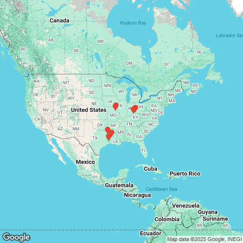
Pustulosa nodulata — Neemuchwala et al. (2023), FMCS (2025), Campbell & Lydeard (2026) RangeWidespread in the Interior Basin and the western Gulf Coastal Plain, USA. Map of Georeferenced Specimens
USAGeoreferenced Genbank Vouchers
USAUAUC_2592. (ND1: AY158756, go to Genbank) Mississippi R., Marion Co., Missouri. UAUC_2595. (ND1: AY158755, go to Genbank) Neches R.,TylerCo.,Texas. UF_439202. (SRA: SRX13980287, go to Genbank) USA, Missouri, Ralls County, Salt River approximately 2.0 river miles downstream of Clarence Cannon Dam (39.5254, -91.609). UF_439202 (QnodSal021). (COI: MH362114, ND1: MH361771, go to Genbank) ditto. UF_439202 (QnodSal022). (COI: MH362115, ND1: MH361772, go to Genbank) ditto. UF_439202 (QnodSal023). (COI: MH362116, ITS1, 5.8S: MH362648, ND1: MH361773, go to Genbank) ditto. UF_439202 (QnodSal024). (COI: MH362117, ND1: MH361774, go to Genbank) ditto. UF_439202 (QnodSal025). (COI: MH362118, ND1: MH361775, go to Genbank) ditto. UF_439180 (QmorRed050). (COI: MH362105, ND1: MH361762, go to Genbank) USA, Texas, Marion County, Big Cypress Bayou (just downstream from Hwy 59, near Jefferson, TX) (32.739928, -94.441666). UF_439197 (QnodNec017). (COI: MH362112, ND1: MH361769, go to Genbank) USA, Texas, Tyler County, Neches River, backwater near mouth of oxbow (30.659012, -94.170894). UF_439197 (QnodNec019). (COI: MH362113, ND1: MH361770, go to Genbank) ditto. JBFMC_12104_1. (16S: PQ238844, go to Genbank) USA: Louisiana, Bayou Pierre. |