| Page last updated
Thu 3 September 2025 |
The Freshwater Mussels (Unionoida) of the World (and other less consequential bivalves)
FM(U)otW(aolcb) is the web version of the MUSSEL Project Database. Follow the links to browse the data or use the custom Google search field. Either way, you win!
Search the database pages:
Bivalvia | Unionida | Unionoidea | Unionidae | Ambleminae | Pleurobemini | Fusconaia species Fusconaia flava (Rafinesque, 1820): specimens
12 available nominal species synonyms (21 total synonyms) Recent Taxonomic OpinionsFusconaia flava — Graf & Cummings (2007), Burdick & White (2007), Tiemann et al. (2007), Williams et al. (2008), Chapman et al. (2008), ... Hopper et al. (2023), Hauck et al. (2023), Freeman et al. (2025), FMCS (2025), Campbell & Lydeard (2026)
Fusconaia hebetata — Graf & Cummings (2007), Cummings & Graf (2010), Campbell & Lydeard (2012), Burlakova et al. (2012), Campbell & Lydeard (2026)
Fusconaia “askewi” — Burlakova et al. (2012)
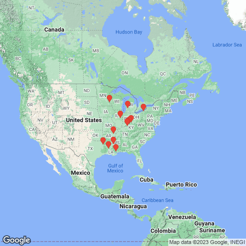
Fusconaia undata — ITIS (2012) RangeWidespread in the Interior, Great Lakes and Nelson River basins, as well as the western Gulf Coastal Plain, North America. Introduced to the Atlantic Slope via the Erie Canal. Map of Georeferenced Specimens
USA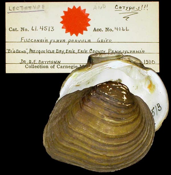
CM_61.4513
“Big Bend” Presque Isle Bay, Erie, Erie County, Pennsylvania
| 
USNM_272249
Cache R., Nemo, Craighead, Ark
| 
FMNH_22816
Cache River, at Nemo, Craighead Co., Arkansas
| 
FMNH_22816
Cache River, at Nemo, Craighead Co., Arkansas
| 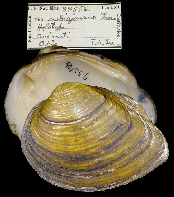
USNM_84556
Cincinnati, Ohio
| 
UMMZ_209194
Lake Pepin, Lake City, Minnesota
| 
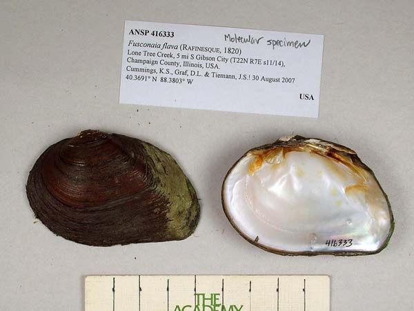
ANSP_416333
Lone Tree Creek, 5 mi S Gibson City, Champaign Co., Illinois 40.3691° N, 88.3803° W
| 
ANSP_416333
Lone Tree Creek, 5 mi S Gibson City, Champaign Co., Illinois 40.3691° N, 88.3803° W
| 
USNM_84629
Louisville, KY
| 
ANSP_20247
Riv. Kentucky
| 
ANSP_20230
small creeks in Kentucky
|
Georeferenced Genbank Vouchers
USAUAUC_2864. (ND1: AY613793, go to Genbank) Big Sunflower River, end of FS Rd 717A, N of Green Ash/Greentree Reeservoir. 6 mi E of Rolling Fork, Sharkey Co. MS. UMMZ_265702. (COI: AF156510, go to Genbank) Grand River, MI. UAUC_146. (16S: AY655042, 16S: AF232797, COI: AF232822, ITS1: DQ383442, ND1: AY158781, go to Genbank) Ohio River, Rosewood Bend, RM 625, Harris Co. IN, Jefferson Co. KY. UF_375436_1. (COI: MF961901, ITS1, 5.8S: MH133883, ND1: MH133764, go to Genbank) USA, Louisiana, Grant Parish, Gray Creek in Kisatchie National Forest, on Brime Road, at 2.5 Mi. SW of Bentley. (31.489898, -92.518157). UF_375436_2. (16S: MK001795, 28S: MK001829, COI: KT285634, ITS1, 5.8S: KT285678, go to Genbank) ditto. UF_375436_3. (COI: KT285635, ITS1, 5.8S: KT285679, go to Genbank) ditto. UF_375436_4. (COI: KT285636, COI: MF961902, ITS1, 5.8S: KT285680, ITS1, 5.8S: MH133884, ND1: MH133765, go to Genbank) ditto. UF_439077_5. (COI: MF961896, ITS1, 5.8S: MH133881, ND1: MH133762, go to Genbank) USA, Louisiana, St. Tammany Parish, Bogue Chitto River near Lock 2 (30.62254, -89.87655). UF_439077_6. (COI: MF961897, ITS1, 5.8S: MH133882, ND1: MH133763, go to Genbank) ditto. UF_438975_10. (COI: MF961893, ITS1, 5.8S: MH133887, ND1: MH133768, go to Genbank) USA, Texas, Marion County, Big Cypress Bayou (just downstream from Hwy 59, near Jefferson, TX) (32.739928, -94.441666). UF_438975_8. (COI: MF961891, ITS1, 5.8S: MH133885, ND1: MH133766, go to Genbank) USA, Texas, Marion County, Big Cypress Bayou (just downstream from Hwy 59, near Jefferson, TX) (32.739928, -94.441666) . UF_438975_9. (COI: MF961892, ITS1, 5.8S: MH133886, ND1: MH133767, go to Genbank) USA, Texas, Marion County, Big Cypress Bayou (just downstream from Hwy 59, near Jefferson, TX) (32.739928, -94.441666). |