| Page last updated
Thu 3 September 2025 |
The Freshwater Mussels (Unionoida) of the World (and other less consequential bivalves)
FM(U)otW(aolcb) is the web version of the MUSSEL Project Database. Follow the links to browse the data or use the custom Google search field. Either way, you win!
Search the database pages:
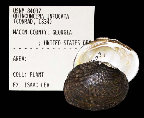
Bivalvia | ... | Unionoidea | Unionidae | Ambleminae | Quadrulini | Quadrulina | Pustulosa species Pustulosa infucata (Conrad, 1834): specimens
2 available nominal species synonyms Recent Taxonomic OpinionsQuincuncina infucata — Graf & Cummings (2007), Zhou et al. (2007), Cummings & Graf (2010), ITIS (2012), Szumowski et al. (2012)
Quadrula infucata — Williams et al. (2008), Bogan (2010), Williams et al. (2011), Haag (2012), Williams et al. (2014)
Rotundaria infucata — Campbell & Lydeard (2012), Campbell & Lydeard (2012)
Amphinaias infucata — ITIS (2013)
Cyclonaias infucata — Williams et al. (2017), Johnson et al. (2018), Lopes-Lima et al. (2019), Graf & Cummings (2021), FMCS (2021), Hopper et al. (2023)
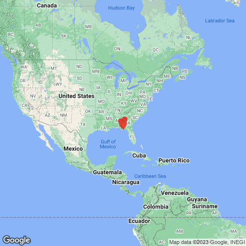
Pustulosa infucata — Neemuchwala et al. (2023), FMCS (2025), Campbell & Lydeard (2026) RangeApalachicola and Ochlockonee rivers, Alabama, Georgia, and Florida, USA. Map of Georeferenced Specimens
USAGeoreferenced Genbank Vouchers
USAUAUC_3283. (ND1: AY655121, go to Genbank) Flint River, Cooleewahee Ck., GA Rt. 91 bridge, Baker Co. GA. UAUC_561. (16S: AF232782, COI: AF232807, go to Genbank) Kinchafoonee Creek, Flint River, Georgia. UAUC_605. (16S: AF232781, COI: AF232806, go to Genbank) ditto. UAUC_920. (ND1: AY158810, go to Genbank) Ochlocknee R., Leon Co., Florida. UAUC_919-926. (16S: AF232780, COI: AF232805, go to Genbank) Ocklockonee River, Florida. UF_438635 (QinfChi014). (COI: MH633620, ITS1, 5.8S: MH362476, ND1: MH633572, go to Genbank) USA, Alabama, Houston County, Big Creek about 400 m upstream of Co. Rt 55 bridge about 5 km SW of Cottonwood (31.02714, -85.35429). UF_441246 (QinfFli034). (COI: MH633647, ITS1, 5.8S: MH362649, ND1: MH633599, go to Genbank) USA, Alabama, Houston County, Big Creek at St. Hwy 109, just E of Merritts Crossroads, 3 mi. S of Rehobeth, AL (31.07772, -85.45664). UF_438764 (QinfChi015). (COI: MH633621, ITS1, 5.8S: MH362477, ND1: MH633573, go to Genbank) USA, Alabama, Houston County, Cowarts Creek on Rocky Creek Road ENE of Cottonwood (31.07521, -85.21861). UF_438764 (QinfChi016). (COI: MH633622, ITS1, 5.8S: MH362478, ND1: MH633574, go to Genbank) ditto. UF_438764 (QinfChi017). (COI: MH633623, ITS1, 5.8S: MH362479, ND1: MH633575, go to Genbank) ditto. UF_438764 (QinfChi019). (COI: MH633624, ITS1, 5.8S: MH362480, ND1: MH633576, go to Genbank) ditto. UF_438764 (QinfChi020). (COI: MH633625, ITS1, 5.8S: MH362481, ND1: MH633577, go to Genbank) ditto. UF_438351 (QinfOch024). (COI: MH633628, ITS1, 5.8S: MH362484, ND1: MH633580, go to Genbank) USA, Florida, Gadsden County, Ochlockonee River about 150 m upstream of US 90 bridge (30.47529, -84.40481). UF_438351 (QinfOch026). (COI: MH633629, ITS1, 5.8S: MH362485, ND1: MH633581, go to Genbank) ditto. UF_438029 (QinfChi030). (COI: MH633649, ITS1, 5.8S: MH362653, ND1: MH633601, go to Genbank) USA, Florida, Gulf County, Chipola River about 2.9 air miles E of Wewahitchka (30.11459, -85.1709). UF_438029 (QinfChi031). (COI: MH633650, ITS1, 5.8S: MH362654, ND1: MH633602, go to Genbank) ditto. UF_438029 (QinfChi032). (COI: MH633651, ITS1, 5.8S: MH362655, ND1: MH633603, go to Genbank) ditto. UF_438029 (QinfChi033). (COI: MH633652, ITS1, 5.8S: MH362656, ND1: MH633604, go to Genbank) ditto. UF_438982 (QinfChi028). (COI: MH633630, ITS1, 5.8S: MH362486, ND1: MH633582, go to Genbank) USA, Florida, Jackson County, Dry Creek at Iron Bridge Road (30.674478, -85.208681). UF_438520 (QinfChi007). (COI: MH633615, ITS1, 5.8S: MH362467, ND1: MH633567, go to Genbank) USA, Florida, Jackson County, Sugar Mill Spring Run in Florida Caverns State Park North of Marianna (30.8222, -85.2439). UF_438331 (QinfOch021). (COI: MH633626, ITS1, 5.8S: MH362482, ND1: MH633578, go to Genbank) USA, Florida, Leon County, Ochlockonee River at upper end of Lake Talquin about 200 m upstream of I10 bridge (30.48789, -84.39746). UF_438393 (QinfOch022). (COI: MH633627, ITS1, 5.8S: MH362483, ND1: MH633579, go to Genbank) USA, Florida, Liberty/Wakulla Cos., Ochlockonee River 1.1 RM upstream of Telogia Creek confluence (30.27568, -84.72896). UF_438721 (QkleOch001). (COI: MH633610, ITS1, 5.8S: MH362455, ND1: MH633562, go to Genbank) USA, Florida, Wakulla/Liberty County, Ochlockonee River on left descending bank (LDB) about 500 m below Silver Lake Landing boat ramp (30.065711, -84.615969). UF_440951. (SRA: SRX13980273, go to Genbank) USA, Georgia, Baker/Mitchell County, Flint River, about 1 mi. upstream of mouth of Ichawaynochaway Creek. (31.1703, -84.456). UF_440951 (QinfFli009). (COI: MH633616, ITS1, 5.8S: MH362468, ND1: MH633568, go to Genbank) ditto. UF_440951 (QinfFli010). (COI: MH633617, ITS1, 5.8S: MH362469, ND1: MH633569, go to Genbank) ditto. UF_440951 (QinfFli011). (COI: MH633618, ITS1, 5.8S: MH362470, ND1: MH633570, go to Genbank) ditto. |