| Page last updated
Thu 3 September 2025 |
The Freshwater Mussels (Unionoida) of the World (and other less consequential bivalves)
FM(U)otW(aolcb) is the web version of the MUSSEL Project Database. Follow the links to browse the data or use the custom Google search field. Either way, you win!
Search the database pages:
Bivalvia | Unionida | Unionoidea | Unionidae | Ambleminae | Pleurobemini | Pleurobema species Pleurobema sintoxia (Rafinesque, 1820): specimens
19 available nominal species synonyms (38 total synonyms) Recent Taxonomic OpinionsPleurobema rubrum — Graf & Cummings (2007), Burdick & White (2007), Tiemann et al. (2007), Williams et al. (2008), Campbell et al. (2008), ... Inoue et al. (2018), Klymus et al. (2020), Graf & Cummings (2021), FMCS (2021), Hopper et al. (2023)
Pleurobema sintoxia — Graf & Cummings (2007), Burdick & White (2007), Tiemann et al. (2007), Williams et al. (2008), Chapman et al. (2008), ... Hopper et al. (2023), Johnson et al. (2024), FMCS (2025), Freeman et al. (2025), Campbell & Lydeard (2026)
Pleurobema coccineum — Hoeh et al. (2009), ITIS (2012)
Pleurobema (Sintoxia) rubrum — Campbell & Lydeard (2012), Burlakova et al. (2012)
Pleurobema (Sintoxia) sintoxia — Campbell & Lydeard (2012), Campbell & Lydeard (2012), Burlakova et al. (2012)
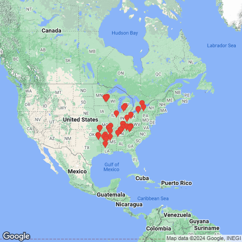
Pleurobema pyramidatum — ITIS (2012) RangeWidespread in the Mississippi River drainage and the Great Lakes, North America. Map of Georeferenced Specimens
unknown
USA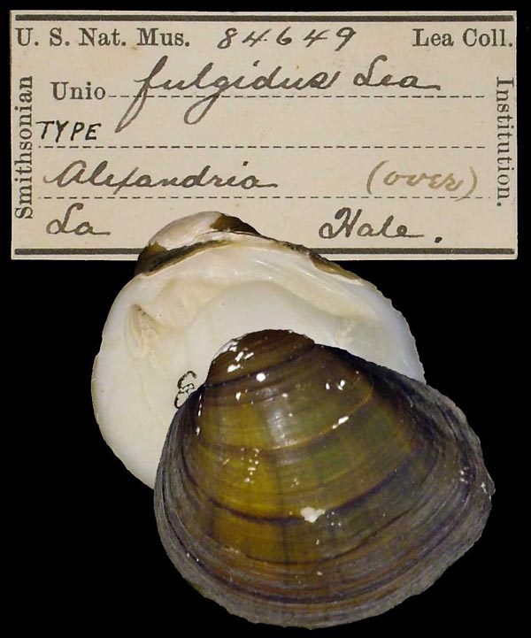
USNM_84649
Alexandria, La
| 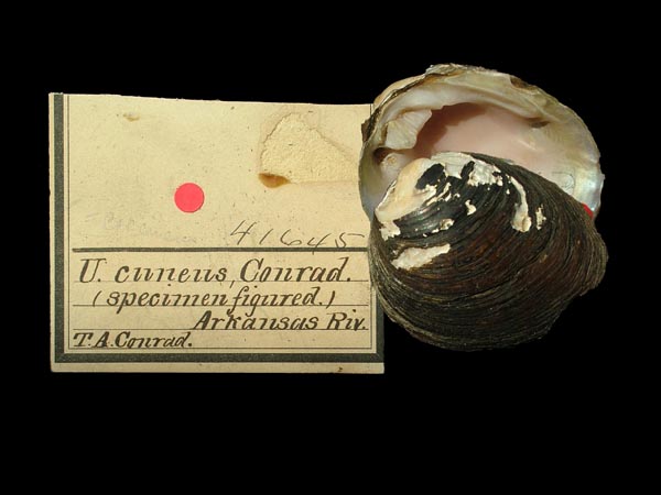
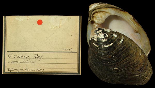
ANSP_41645
Arkansas River
| 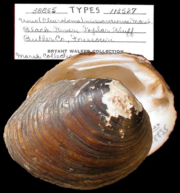
UMMZ_113527
Black River, Poplar Bluff, Butler Co., Missouri
| 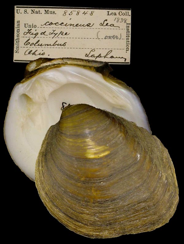
USNM_85848
Columbus, Ohio
| 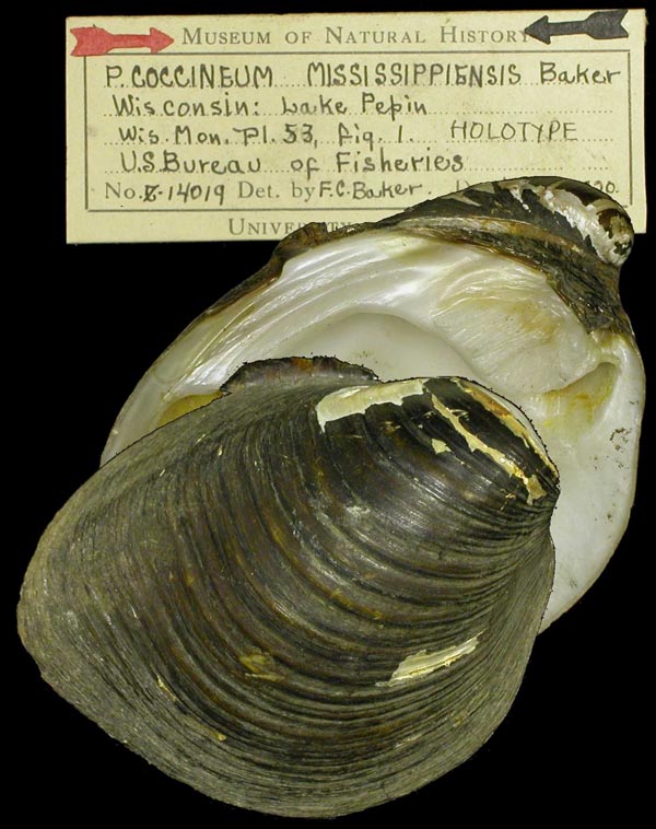
INHS_82273
Lake Pepin, Wisconsin
| 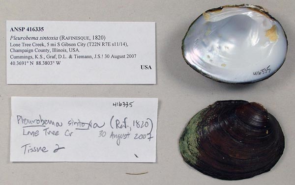
ANSP_416335
Lone Tree Creek, 5 mi S Gibson City, Champaign Co., Illinois 40.3691° N, 88.3803° W
| 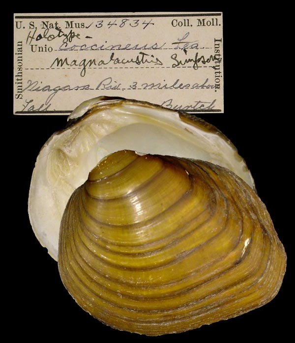
USNM_133834
Niagara Riv., 3 mi above Falls
| 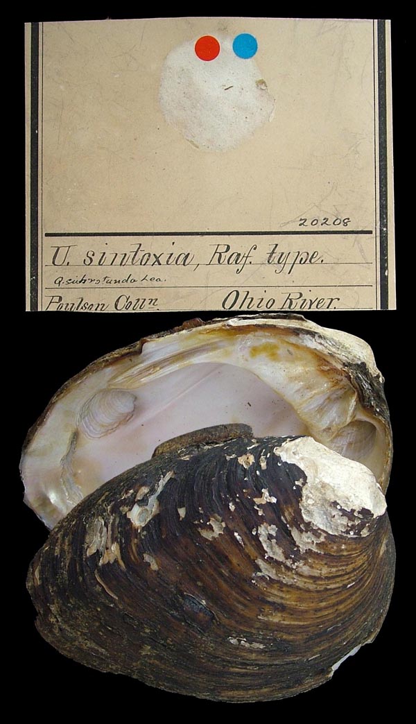
ANSP_20208
Ohio River
| 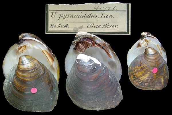
ANSP_41726
Ohio River
|
Georeferenced Genbank Vouchers
USAMCM_20346 (PrubOua242). (COI: OR633046, ND1: OR635276, go to Genbank) Bayou Bartholomew 'Site 26' adjacent to Highway 165. 2 km south of the intersection of Highway 165 and Spyker Road, Morehouse Co., Louisiana (32.75389, -91.9647). MCM_20346 (PrubOua243). (COI: OR633047, ND1: OR635277, go to Genbank) ditto. MCM_18881 (PrubOua214). (COI: OR633044, ND1: OR635274, go to Genbank) Bayou Bartholomew at Pleasant Drive (county road 830-1) equal distance between Newman Road and Cave Off Road, Morehouse Co., Louisiana (32.801362, -91.949655). MCM_18881 (PrubOua215). (COI: OR633045, ND1: OR635275, go to Genbank) ditto. MCM_11728 (PsinBSF021). (18S, 5.8S, ITS1: OR646452, COI: OR633088, ND1: OR635318, go to Genbank) Big South Fork of the Cumberland River at confluence of Parch Corn Creek, Scott Co., Tennessee (36.55823, -84.67173). MCM_11728 (PsinBSF022). (18S, 5.8S, ITS1: OR646453, COI: OR633089, ND1: OR635319, go to Genbank) ditto. MCM_11728 (PsinBSF023). (18S, 5.8S, ITS1: OR646454, COI: OR633090, ND1: OR635320, go to Genbank) ditto. MCM_11728 (PsinBSF024). (18S, 5.8S, ITS1: OR646455, COI: OR633091, ND1: OR635321, go to Genbank) ditto. MCM_11728 (PsinBSF025). (18S, 5.8S, ITS1: OR646456, COI: OR633092, ND1: OR635322, go to Genbank) ditto. UF_439493 (PrubYaz063). (COI: OR633076, ND1: OR635306, go to Genbank) Big Sunflower River at Blaine Road Bridge, Sunflower Co., Mississippi (33.601156, -90.53817). UF_439493 (PrubYaz064). (18S, 5.8S, ITS1: OR646445, COI: OR633077, ND1: OR635307, go to Genbank) ditto. UF_439493 (PrubYaz065). (18S, 5.8S, ITS1: OR646446, COI: OR633078, ND1: OR635308, go to Genbank) ditto. UF_439493 (PrubYaz066). (COI: OR633079, ITS1, 5.8S: OR646447, ND1: OR635309, go to Genbank) ditto. UF_439493 (PrubYaz067). (COI: OR633080, ITS1: OR646448, ND1: OR635310, go to Genbank) ditto. UF_439493 (PrubYaz068). (COI: OR633081, ITS1: OR646449, ND1: OR635311, go to Genbank) ditto. UF_439493 (PrubYaz069). (18S, 5.8S, ITS1: OR646450, COI: OR633082, ND1: OR635312, go to Genbank) ditto. UF_439493 (PrubYaz070). (18S, 5.8S, ITS1: OR646451, COI: OR633083, ND1: OR635313, go to Genbank) ditto. UF_439546 (PsinWhi163). (COI: OR633164, ND1: OR635394, go to Genbank) Black River, ~200m upstream of Davidsonville Historic State Park access, Randolph Co., Arkansas (36.152724, -91.052682). UF_439546 (PsinWhi164). (COI: OR633165, ND1: OR635395, go to Genbank) ditto. UF_439546 (PsinWhi165). (COI: OR633166, ND1: OR635396, go to Genbank) ditto. UF_439546 (PsinWhi166). (COI: OR633167, ND1: OR635397, go to Genbank) ditto. UF_439546 (PsinWhi167). (COI: OR633168, ND1: OR635398, go to Genbank) ditto. UF_439546 (PsinWhi168). (COI: OR633169, ND1: OR635399, go to Genbank) ditto. UF_439546 (PsinWhi169). (COI: OR633170, ND1: OR635400, go to Genbank) ditto. UF_439546 (PsinWhi170). (COI: OR633171, ND1: OR635401, go to Genbank) ditto. UF_439546 (PsinWhi171). (COI: OR633172, ND1: OR635402, go to Genbank) ditto. UF_439546 (PsinWhi172). (COI: OR633173, ND1: OR635403, go to Genbank) ditto. UF_439546 (PsinWhi173). (COI: OR633174, ND1: OR635404, go to Genbank) ditto. UF_439546 (PsinWhi174). (COI: OR633175, ND1: OR635405, go to Genbank) ditto. UF_439356 (PsinChi001). (COI: OR633093, ITS1, 5.8S: OR646457, ND1: OR635323, go to Genbank) Chippewa River just downstream of County Hwy H crossing about 10 miles WSW of Eau Claire WI, Dunn Co., Wisconsin (44.76085278, -91.6783945). UF_439356 (PsinChi002). (COI: OR633094, ITS1, 5.8S: OR646458, ND1: OR635324, go to Genbank) ditto. UF_439356 (PsinChi003). (COI: OR633095, ITS1: OR646459, ND1: OR635325, go to Genbank) ditto. UF_439356 (PsinChi004). (COI: OR633096, ITS1, 5.8S: OR646460, ND1: OR635326, go to Genbank) ditto. UF_439356 (PsinChi005). (COI: OR633097, ND1: OR635327, go to Genbank) ditto. UF_439356 (PsinChi006). (COI: OR633098, ITS1: OR646461, ND1: OR635328, go to Genbank) ditto. UF_439373 (PrubCli003). (5.8S, ITS1: OR646411, COI: OR633009, ND1: OR635239, go to Genbank) Clinch River at Brooks Island; about 5 miles east of Sneedville, TN, Hancock Co., Tennessee (36.54014, -83.13069). Mp_4363_PrubCli023. (COI: OR633012, ND1: OR635242, go to Genbank) Clinch River Brooks Island Swan Island, Hancock Co., Tennessee (36.47349, -83.28995). Mp_4363_PrubCli024. (COI: OR633013, ND1: OR635243, go to Genbank) ditto. Mp_4363_PrubCli020. (18S, 5.8S, ITS1: OR646412, COI: OR633010, ND1: OR635240, go to Genbank) Clinch River Brooks Island, Hancock Co., Tennessee (36.47349, -83.28995). Mp_4363_PrubCli021. (18S, 5.8S, ITS1: OR646413, COI: OR633011, ND1: OR635241, go to Genbank) ditto. UF_439494 (PrubCli074). (COI: OR633014, ITS1: OR646414, ND1: OR635244, go to Genbank) Clinch River, So. of town of Sneedville-Frost Ford (RM182), Hancock Co., Tennessee (36.5307712, -83.150753). Mp_4363_PspeCli001. (18S, 5.8S, ITS1: OR646509, COI: OR633199, ND1: OR635429, go to Genbank) Clinch River; Brooks Island; Frost Parker, Hancock Co., Tennessee (36.47349, -83.28995). Mp_4363_PspeCli003. (COI: OR633200, ITS1: OR646510, ND1: OR635430, go to Genbank) ditto. Mp_4363_PsinCum104. (18S, 5.8S, ITS1: OR646463, COI: OR633100, ND1: OR635330, go to Genbank) Cumberland River Mile 297.8 Back shoot of Lovells Island, Smith Co., Tennessee (36.30438333333333, -86.04685). UAUC_1714. (COI: AY655019, ITS1: DQ470006, ND1: AY613815, go to Genbank) Cumberland River, Big South Fork at Station Camp Creek, Scott Co. TN. UF_439375 (PrubDuc007). (18S, 5.8S, ITS1: OR646416, go to Genbank) Duck River at Hooper Island (Duck River Mile 163.1), Maury Co., Tennessee (35.601603, -86.874806). UF_439375 (PrubDuc008). (18S, 5.8S, ITS1: OR646417, COI: OR633016, ND1: OR635246, go to Genbank) ditto. UF_439375 (PrubDuc010). (COI: OR633017, ITS1: OR646418, ND1: OR635247, go to Genbank) ditto. UF_439375 (PrubDuc011). (ITS1: OR646419, go to Genbank) ditto. UF_439375 (PrubDuc014). (18S, 5.8S, ITS1: OR646420, COI: OR633018, ND1: OR635248, go to Genbank) ditto. UF_439374 (PrubDuc004). (COI: OR633015, ITS1, 5.8S: OR646415, ND1: OR635245, go to Genbank) Duck River at Lillard's Mill (river mile 179), Marshall Co., Tennessee (35.58603, -86.78844). Mp_4363_PrubDuc015. (COI: OR633019, ITS1: OR646421, ND1: OR635249, go to Genbank) Duck River at Lillard's Mill (river mile 179), Maury Co., Tennessee (35.601603, -86.874806). UF_439586 (PrubDuc042). (18S, 5.8S, ITS1: OR646422, COI: OR633020, ND1: OR635250, go to Genbank) ditto. UAUC_2719. (COI: AY655018, ND1: AY655117, go to Genbank) Duck River, Venable Spring, Marshall Co. TN. Mp_2667_H1766. (COI: EF033253, COII: EF033273, go to Genbank) East Fork of the White River, downstream of US 50/SR 37 bridge, Lawrence County, Indiana. Mp_2667_H1767g. (COI M-type: EF033291, COII M-type: EF033311, go to Genbank) ditto. Mp_4363_PspeGre063. (COI: OR633201, ND1: OR635431, go to Genbank) Green River at Stovall Park, Hart Co., Kentucky (37.26638, -85.88874). Mp_4363_PrubGre017. (18S, 5.8S, ITS1: OR646424, COI: OR633022, ND1: OR635252, go to Genbank) Green River at Thomas Bend, Edmonson Co., Kentucky (37.296108, -85.811534). Mp_4363_PrubGre019. (COI: OR633023, ITS1: OR646425, ND1: OR635253, go to Genbank) ditto. Mp_4363_PsinGre105. (18S, 5.8S, ITS1: OR646479, COI: OR633115, ND1: OR635345, go to Genbank) ditto. Mp_4363_PsinGre106. (18S, 5.8S, ITS1: OR646480, COI: OR633116, ND1: OR635346, go to Genbank) ditto. Mp_4363_PsinGre107. (COI: OR633117, ND1: OR635347, go to Genbank) ditto. Mp_4363_PsinGre108. (COI: OR633118, ND1: OR635348, go to Genbank) ditto. Mp_4363_PsinGre110. (COI: OR633119, ND1: OR635349, go to Genbank) ditto. Mp_4363_PsinGre111. (COI: OR633120, ND1: OR635350, go to Genbank) ditto. Mp_4363_PsinGre112. (COI: OR633121, ITS1, 5.8S: OR646481, ND1: OR635351, go to Genbank) ditto. Mp_4363_PsinGre113. (COI: OR633122, ND1: OR635352, go to Genbank) ditto. Mp_4363_PsinGre114. (COI: OR633123, ND1: OR635353, go to Genbank) ditto. Mp_4363_PsinGre115. (COI: OR633124, ND1: OR635354, go to Genbank) ditto. Mp_4363_PsinGre116. (COI: OR633125, ND1: OR635355, go to Genbank) ditto. Mp_4363_PsinGre117. (COI: OR633126, ITS1, 5.8S: OR646482, ND1: OR635356, go to Genbank) ditto. Mp_4363_PsinGre118. (18S, 5.8S, ITS1: OR646483, COI: OR633127, ND1: OR635357, go to Genbank) ditto. Mp_4363_PsinGre120. (COI: OR633128, ND1: OR635358, go to Genbank) ditto. Mp_4363_PsinGre121. (COI: OR633129, ND1: OR635359, go to Genbank) ditto. Mp_4363_PsinGre122. (COI: OR633130, ND1: OR635360, go to Genbank) ditto. Mp_4363_PsinGre123. (COI: OR633131, ND1: OR635361, go to Genbank) ditto. Mp_4363_PsinGre124. (COI: OR633132, ND1: OR635362, go to Genbank) ditto. Mp_4363_PsinGre125. (18S, 5.8S, ITS1: OR646484, COI: OR633133, ND1: OR635363, go to Genbank) ditto. Mp_4363_PsinGre126. (18S, 5.8S, ITS1: OR646485, COI: OR633134, ND1: OR635364, go to Genbank) ditto. Mp_4363_PsinGre127. (COI: OR633135, ITS1, 5.8S: OR646486, ND1: OR635365, go to Genbank) ditto. Mp_4363_PsinGre128. (18S, 5.8S, ITS1: OR646487, COI: OR633136, ND1: OR635366, go to Genbank) ditto. Mp_4363_PsinGre129. (18S, 5.8S, ITS1: OR646488, COI: OR633137, ND1: OR635367, go to Genbank) ditto. Mp_4363_PsinGre130. (COI: OR633138, ITS1, 5.8S: OR646489, ND1: OR635368, go to Genbank) ditto. Mp_4363_PsinGre131. (COI: OR633139, ND1: OR635369, go to Genbank) ditto. Mp_4363_PsinGre026. (COI: OR633101, ITS1, 5.8S: OR646464, ND1: OR635331, go to Genbank) Green River, Western Kentucky Bioreserve, Edmonson Co., Kentucky (37.24609, -85.9973). Mp_4363_PsinGre028. (COI: OR633102, ITS1, 5.8S: OR646465, ND1: OR635332, go to Genbank) ditto. Mp_4363_PsinGre029. (COI: OR633103, ITS1: OR646466, ND1: OR635333, go to Genbank) ditto. Mp_4363_PsinGre030. (COI: OR633104, ITS1: OR646467, ND1: OR635334, go to Genbank) ditto. Mp_4363_PsinGre032. (COI: OR633105, ITS1, 5.8S: OR646468, ND1: OR635335, go to Genbank) ditto. Mp_4363_PsinGre033. (COI: OR633106, ITS1, 5.8S: OR646469, ND1: OR635336, go to Genbank) ditto. Mp_4363_PsinGre035. (COI: OR633107, ITS1: OR646470, ND1: OR635337, go to Genbank) ditto. Mp_4363_PsinGre036. (COI: OR633108, ITS1, 5.8S: OR646471, ND1: OR635338, go to Genbank) ditto. Mp_4363_PsinGre037. (COI: OR633109, ITS1, 5.8S: OR646472, ND1: OR635339, go to Genbank) ditto. Mp_4363_PsinGre038. (COI: OR633110, ITS1, 5.8S: OR646473, ND1: OR635340, go to Genbank) ditto. Mp_4363_PsinGre039. (COI: OR633111, ITS1, 5.8S: OR646474, ND1: OR635341, go to Genbank) ditto. Mp_4363_PsinGre040. (ITS1, 5.8S: OR646475, go to Genbank) ditto. Mp_4363_PsinGre041. (COI: OR633112, ITS1, 5.8S: OR646476, ND1: OR635342, go to Genbank) ditto. Mp_4363_PsinGre043. (COI: OR633113, ITS1, 5.8S: OR646477, ND1: OR635343, go to Genbank) ditto. Mp_4363_PsinGre044. (COI: OR633114, ITS1: OR646478, ND1: OR635344, go to Genbank) ditto. UF_439386 (PrubGre005). (COI: OR633021, ITS1, 5.8S: OR646423, ND1: OR635251, go to Genbank) ditto. MCM_20330 (PrubTen086). (COI: OR633075, ND1: OR635305, go to Genbank) Holston River, McKinney Islands, River mile 25.3, Jefferson Co., Tennessee (36.10529, -83.66945). ASUMZ_1384_1 (Psin_ILL02). (COI: OR633085, ND1: OR635315, go to Genbank) Illinois River ca. 0.32 river km upstream of Robinson Rd and 11.7 air km SW of Tontitown, Washington Co., Arkansas (36.13541, -94.3546). ASUMZ_1383_1 (Psin_ILL01). (COI: OR633084, ND1: OR635314, go to Genbank) Illinois River ca. 3.45 river km downstream of Chamber Springs Rd and 6.0 river km upstream of AR Hwy 16, and ca. 8.35 air km ESE center of Siloam Springs., Benton Co., Arkansas (36.16227, -94.45127). UMMZ_265703. (COI: AF156508, go to Genbank) Kalamazoo River, MI. ASU_1376_1 (PspeRed004). (18S, 5.8S, ITS1: OR646511, COI: OR633202, ND1: OR635432, go to Genbank) Little River ca. 3.95 river km downstream of Co. Rd. D4615 and ca. 1.0 rkm upstream of Salt Creek confluence and 5.37 air km NNE center of Idabel., McCurtain Co., Oklahoma (33.940604, -94.811604). ASU_1376_2 (PspeRed005). (18S, 5.8S, ITS1: OR646512, COI: OR633203, ND1: OR635433, go to Genbank) ditto. ASU_1376_3 (PspeRed006). (18S, 5.8S, ITS1: OR646513, COI: OR633204, ND1: OR635434, go to Genbank) ditto. ASU_1376_4 (PspeRed007). (18S, 5.8S, ITS1: OR646514, COI: OR633205, ND1: OR635435, go to Genbank) ditto. ASU_1376_5 (PspeRed008). (18S, 5.8S, ITS1: OR646515, COI: OR633206, ND1: OR635436, go to Genbank) ditto. ASUMZ_1382_1 (Psin_RED06). (COI: OR633086, ND1: OR635316, go to Genbank) Little River, At Co. Rd. E2090 immediately downstream of Possum Ford Bend and 2.54 air km NNE center of Garvin, McCurtain Co., Oklahoma (33.9762, -94.9322). ASUMZ_1382_2 (Psin_RED07). (COI: OR633087, ND1: OR635317, go to Genbank) ditto. Mp_4363_PsinMis067. (COI: OR633140, ND1: OR635370, go to Genbank) Mississippi River in Pool 4 adjacent to Wabasha, MN, on the Wisconsin side of the river, Pepin Co., Minnesota/Wisconsin (44.412, -92.094897). ASU_1344_1 (PrubOua025). (COI: OR633025, ND1: OR635255, go to Genbank) Ouachita River ca. 1.81 river km upstream confluence with Ecore Fabre Bayou and 4.25 air km N center of Camden., Ouachita Co., Arkansas (33.62299, -92.83253). ASU_1344_2 (PrubOua026). (COI: OR633026, ND1: OR635256, go to Genbank) ditto. ASU_1344_3 (PrubOua027). (COI: OR633027, ND1: OR635257, go to Genbank) ditto. ASU_1344_4 (PrubOua028). (COI: OR633028, ND1: OR635258, go to Genbank) ditto. ASU_1344_5 (PrubOua029). (COI: OR633029, ND1: OR635259, go to Genbank) ditto. UMMZ_265704. (28S: DQ191418, COI: AF156509, go to Genbank) Portage River, near Three Rivers, St. Joseph Co. MI. UF_439542 (PrubOua199). (COI: OR633030, ND1: OR635260, go to Genbank) Saline River ~150m downstream of Hwy 167 bridge, Grant Co., Arkansas (34.114368, -92.404844). UF_439542 (PrubOua200). (COI: OR633031, ND1: OR635261, go to Genbank) ditto. UF_439542 (PrubOua201). (COI: OR633032, ND1: OR635262, go to Genbank) ditto. UF_439542 (PrubOua202). (COI: OR633033, ND1: OR635263, go to Genbank) ditto. UF_439542 (PrubOua203). (COI: OR633034, ND1: OR635264, go to Genbank) ditto. UF_439542 (PrubOua204). (COI: OR633035, ND1: OR635265, go to Genbank) ditto. UF_439542 (PrubOua205). (COI: OR633036, ND1: OR635266, go to Genbank) ditto. UF_439542 (PrubOua206). (COI: OR633037, ND1: OR635267, go to Genbank) ditto. UF_439542 (PrubOua207). (COI: OR633038, ND1: OR635268, go to Genbank) ditto. UF_439542 (PrubOua208). (COI: OR633039, ND1: OR635269, go to Genbank) ditto. UF_439542 (PrubOua209). (COI: OR633040, ND1: OR635270, go to Genbank) ditto. UF_439542 (PrubOua210). (COI: OR633041, ND1: OR635271, go to Genbank) ditto. UF_439542 (PrubOua212). (COI: OR633042, ND1: OR635272, go to Genbank) ditto. UF_439542 (PrubOua213). (COI: OR633043, ND1: OR635273, go to Genbank) ditto. UF_439583 (PspeSal013). (COI: OR633207, ITS1, 5.8S: OR646516, ND1: OR635437, go to Genbank) Saline River appx 4 river miles upstream of Georgia Pacific Lake, Bradley Co., Arkansas (33.28514, -92.00867). UF_439584 (PrubSal035). (18S, 5.8S, ITS1: OR646429, COI: OR633050, ND1: OR635280, go to Genbank) ditto. UF_439584 (PrubSal036). (COI: OR633051, ND1: OR635281, go to Genbank) ditto. UF_439584 (PrubSal037). (18S, 5.8S, ITS1: OR646430, COI: OR633052, ND1: OR635282, go to Genbank) ditto. UF_439584 (PrubSal040). (18S, 5.8S, ITS1: OR646431, COI: OR633053, ND1: OR635283, go to Genbank) ditto. UF_439585 (PrubSal030). (18S, 5.8S, ITS1: OR646427, COI: OR633048, ND1: OR635278, go to Genbank) Saline River, Approx. 4 river miles u/s of Georgia Pacific Lake, Bradley Co., Arkansas (33.28514, -92.00867). UF_439585 (PrubSal033). (18S, 5.8S, ITS1: OR646428, COI: OR633049, ND1: OR635279, go to Genbank) ditto. UF_439361 (PsinShe012). (COI: OR633150, ND1: OR635380, go to Genbank) Shenango River about 2.2 KM NNW of Greenville, PA, Mercer Co., Pennsylvania (41.42345, -80.40055). UF_439361 (PsinShe013). (COI: OR633151, ITS1: OR646499, ND1: OR635381, go to Genbank) ditto. UF_439361 (PsinShe014). (18S, 5.8S, ITS1: OR646500, COI: OR633152, ND1: OR635382, go to Genbank) ditto. UF_439361 (PsinShe017). (COI: OR633153, ITS1: OR646501, ND1: OR635383, go to Genbank) ditto. UF_439361 (PsinShe019). (18S, 5.8S, ITS1: OR646502, COI: OR633154, ND1: OR635384, go to Genbank) ditto. UF_439361 (PsinShe020). (18S, 5.8S, ITS1: OR646503, COI: OR633155, ND1: OR635385, go to Genbank) ditto. UF_439360 (PsinShe007). (18S, 5.8S, ITS1: OR646496, COI: OR633147, ND1: OR635377, go to Genbank) Shenango River about 4.9 KM NNW of Greenville, PA, Mercer Co., Pennsylvania (41.44553, -80.41122). UF_439360 (PsinShe008). (18S, 5.8S, ITS1: OR646497, COI: OR633148, ND1: OR635378, go to Genbank) ditto. UF_439360 (PsinShe009). (18S, 5.8S, ITS1: OR646498, COI: OR633149, ND1: OR635379, go to Genbank) ditto. ASU_1385_1 (PsinWhi132). (18S, 5.8S, ITS1: OR646504, COI: OR633156, ND1: OR635386, go to Genbank) Spring River ca. 2.37 river km downstream of US Hwy 62 in Imboden and immediately upstream of confluence with Davis Creek., Lawrence/Randolph Co., Arkansas (36.197693999999998, -91.155687). ASU_1385_2 (PsinWhi133). (COI: OR633157, ND1: OR635387, go to Genbank) ditto. ASU_1385_3 (PsinWhi134). (COI: OR633158, ND1: OR635388, go to Genbank) ditto. ASU_1385_4 (PsinWhi135). (COI: OR633159, ND1: OR635389, go to Genbank) ditto. ASU_1385_5 (PsinWhi136). (18S, 5.8S, ITS1: OR646505, COI: OR633160, ND1: OR635390, go to Genbank) ditto. UF_439543 (PsinWhi175). (COI: OR633176, ND1: OR635406, go to Genbank) Spring River, tributary of the Black River, ~3.3 air km downstream of US62 bridge crossing, Lawrence Co., Arkansas (36.183264, -91.148556). UF_439543 (PsinWhi176). (COI: OR633177, ND1: OR635407, go to Genbank) ditto. UF_439543 (PsinWhi177). (COI: OR633178, ND1: OR635408, go to Genbank) ditto. UF_439543 (PsinWhi178). (COI: OR633179, ND1: OR635409, go to Genbank) ditto. UF_439543 (PsinWhi179). (COI: OR633180, ND1: OR635410, go to Genbank) ditto. UF_439543 (PsinWhi180). (COI: OR633181, ND1: OR635411, go to Genbank) ditto. UF_439543 (PsinWhi181). (COI: OR633182, ND1: OR635412, go to Genbank) ditto. UF_439543 (PsinWhi182). (COI: OR633183, ND1: OR635413, go to Genbank) ditto. UF_439543 (PsinWhi183). (COI: OR633184, ND1: OR635414, go to Genbank) ditto. UF_439543 (PsinWhi184). (COI: OR633185, ND1: OR635415, go to Genbank) ditto. UF_439543 (PsinWhi185). (COI: OR633186, ND1: OR635416, go to Genbank) ditto. UF_439543 (PsinWhi186). (COI: OR633187, ND1: OR635417, go to Genbank) ditto. UF_439543 (PsinWhi187). (COI: OR633188, ND1: OR635418, go to Genbank) ditto. UF_439543 (PsinWhi188). (COI: OR633189, ND1: OR635419, go to Genbank) ditto. UF_439543 (PsinWhi190). (COI: OR633190, ND1: OR635420, go to Genbank) ditto. UF_439543 (PsinWhi191). (COI: OR633191, ND1: OR635421, go to Genbank) ditto. UF_439543 (PsinWhi192). (COI: OR633192, ND1: OR635422, go to Genbank) ditto. UF_439543 (PsinWhi193). (COI: OR633193, ND1: OR635423, go to Genbank) ditto. UF_439543 (PsinWhi194). (COI: OR633194, ND1: OR635424, go to Genbank) ditto. UF_439543 (PsinWhi195). (COI: OR633195, ND1: OR635425, go to Genbank) ditto. UF_439543 (PsinWhi196). (COI: OR633196, ND1: OR635426, go to Genbank) ditto. UF_439543 (PsinWhi197). (COI: OR633197, ND1: OR635427, go to Genbank) ditto. UF_439543 (PsinWhi198). (COI: OR633198, ND1: OR635428, go to Genbank) ditto. UF_439541 (PrubStF217). (COI: OR633054, ITS1, 5.8S: OR646432, ND1: OR635284, go to Genbank) St. Francis River ca. 2.51 km upstream of Parkin Slough confluence and ca. 2.9 air km SW of US Hwy 64 bridge in Parkin, AR., Cross Co., Arkansas (35.25435, -90.58176). UF_439541 (PrubStF218). (18S, 5.8S, ITS1: OR646433, go to Genbank) ditto. UF_439541 (PrubStF220). (18S, 5.8S, ITS1: OR646434, COI: OR633055, ND1: OR635285, go to Genbank) ditto. UF_439541 (PrubStF221). (COI: OR633056, ND1: OR635286, go to Genbank) ditto. UF_439541 (PrubStF222). (18S, 5.8S, ITS1: OR646435, COI: OR633057, ND1: OR635287, go to Genbank) ditto. UF_439541 (PrubStF223). (COI: OR633058, ITS1, 5.8S: OR646436, ND1: OR635288, go to Genbank) ditto. UF_439541 (PrubStF224). (ITS1: OR646437, go to Genbank) ditto. UF_439541 (PrubStF225). (COI: OR633059, ND1: OR635289, go to Genbank) ditto. UF_439541 (PrubStF226). (COI: OR633060, ND1: OR635290, go to Genbank) ditto. UF_439541 (PrubStF228). (COI: OR633061, ND1: OR635291, go to Genbank) ditto. UF_439541 (PrubStF229). (COI: OR633062, ND1: OR635292, go to Genbank) ditto. UF_439541 (PrubStF230). (COI: OR633063, ND1: OR635293, go to Genbank) ditto. UF_439541 (PrubStF231). (COI: OR633064, ND1: OR635294, go to Genbank) ditto. UF_439541 (PrubStF232). (COI: OR633065, ND1: OR635295, go to Genbank) ditto. UF_439541 (PrubStF233). (COI: OR633066, ND1: OR635296, go to Genbank) ditto. UF_439541 (PrubStF234). (COI: OR633067, ND1: OR635297, go to Genbank) ditto. UAUC_3229. (COI: AY613841, ND1: AY613814, go to Genbank) St. Francis River, Hwy 64 at Parkin, Cross Co. AR. UF_439438 (PrubTen049). (COI: OR633068, ITS1: OR646438, ND1: OR635298, go to Genbank) Tennessee River, Sevenmile Island secondary channel; TRM249.7, Lauderdale Co., Alabama (34.73828, -87.77142). UF_439438 (PrubTen050). (COI: OR633069, ITS1, 5.8S: OR646439, ND1: OR635299, go to Genbank) ditto. UF_439438 (PrubTen052). (18S, 5.8S, ITS1: OR646440, COI: OR633070, ND1: OR635300, go to Genbank) ditto. UF_439438 (PrubTen053). (COI: OR633071, ITS1: OR646441, ND1: OR635301, go to Genbank) ditto. UF_439438 (PrubTen054). (18S, 5.8S, ITS1: OR646442, COI: OR633072, ND1: OR635302, go to Genbank) ditto. UF_439438 (PrubTen055). (18S, 5.8S, ITS1: OR646443, COI: OR633073, ND1: OR635303, go to Genbank) ditto. UF_439438 (PrubTen057). (18S, 5.8S, ITS1: OR646444, COI: OR633074, ND1: OR635304, go to Genbank) ditto. UF_439492 (PsinOhi157). (18S, 5.8S, ITS1: OR646491, COI: OR633142, ND1: OR635372, go to Genbank) upper Allegheny River in Olean, NY; 0.5 mile downstream of South Union Street bridge, Cattaraugus Co., New York (42.0721283, -78.43879295). UF_439492 (PsinOhi158). (18S, 5.8S, ITS1: OR646492, COI: OR633143, ND1: OR635373, go to Genbank) ditto. UF_439492 (PsinOhi159). (18S, 5.8S, ITS1: OR646493, COI: OR633144, ND1: OR635374, go to Genbank) ditto. UF_439492 (PsinOhi160). (18S, 5.8S, ITS1: OR646494, COI: OR633145, ND1: OR635375, go to Genbank) ditto. UF_439492 (PsinOhi161). (18S, 5.8S, ITS1: OR646495, COI: OR633146, ND1: OR635376, go to Genbank) ditto. |