| Page last updated
Thu 3 September 2025 |
The Freshwater Mussels (Unionoida) of the World (and other less consequential bivalves)
FM(U)otW(aolcb) is the web version of the MUSSEL Project Database. Follow the links to browse the data or use the custom Google search field. Either way, you win!
Search the database pages:
Bivalvia | Unionida | Unionoidea | Unionidae | Ambleminae | Lampsilini | Potamilus species Potamilus fragilis (Rafinesque, 1820): specimens
9 available nominal species synonyms (15 total synonyms) Recent Taxonomic OpinionsLeptodea fragilis — Graf & Cummings (2007), Tiemann et al. (2007), Williams et al. (2008), Watters et al. (2009), Bogan (2010), ... Inoue et al. (2020), Klymus et al. (2020), Gasparini et al. (2020), Graf & Cummings (2021), Hauck et al. (2023)
Medionidus mcglameriae — Graf & Cummings (2007), Cummings & Graf (2010), ITIS (2012)
Potamilus fragilis — Smith et al. (2020), Johnson & Smith (2020), Smith & Johnson (2020), FMCS (2021), Keogh et al. (2021), de Moulpied et al. (2022), Hopper et al. (2023), FMCS (2025), Campbell & Lydeard (2026) RangeWidespread in the Interior, Great Lakes and Gulf Coastal Plain basins, North America. Introduced to the Northern Atlantic Slope. Map of Georeferenced Specimens
USA
USNM_86119
Claiborne, Ala.
| 
USNM_86118
Columbus, Miss.
| 
USNM_86118
Columbus, Miss.
| 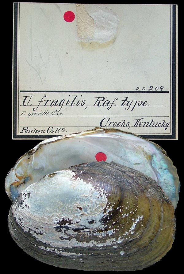
ANSP_20209
creeks, Kentucky
| 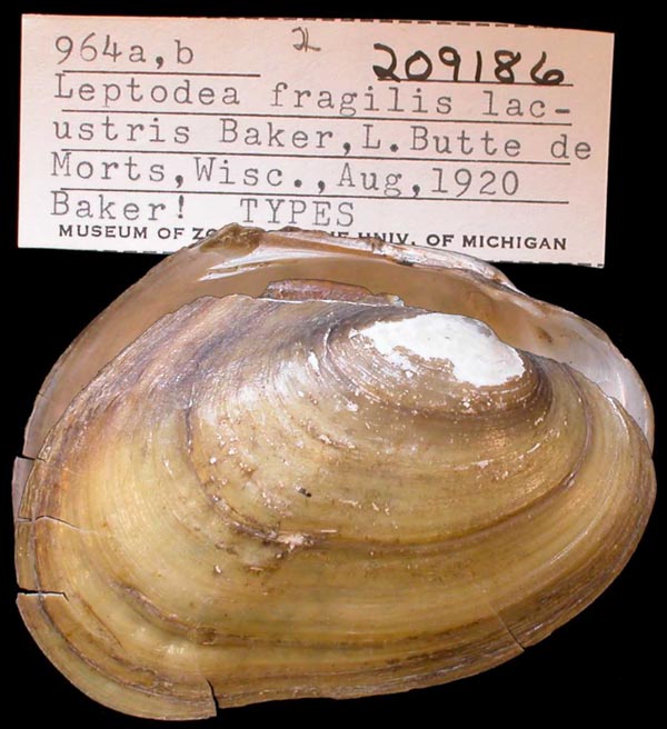
UMMZ_209186
L. Butte de Morts, Wisc.
| 
ANSP_416326
Sangamon River, Lake of the Woods, Mahomet, Champaign Co., Illinois 40.2040° N, 88.3876° W
| 
USNM_160709
Spring R., Hardy, Ark
| 
UMMZ_130460
Tombigbee River, Epes, Sumpter Co., Alabama
|
Georeferenced Genbank Vouchers
USAINHS_39037_1. (28S: MK036091, COI: MK044923, ITS1, 5.8S: MK036174, ND1: MK045074, go to Genbank) Illinois River, Illinois drainage (39.6862, -90.6416). INHS_39037_2. (28S: MK036092, COI: MK044924, ITS1, 5.8S: MK036175, ND1: MK045075, go to Genbank) ditto. INHS_39037_3. (28S: MK036093, COI: MK044925, ITS1, 5.8S: MK036176, ND1: MK045076, go to Genbank) ditto. UF_438237-LfraAla001. (COI: MT662019, FEM1: MT669798, ITS1: MT661766, ND1: MT669665, UbiA1: MT669771, go to Genbank) USA, Alabama, Monroe County, Alabama River at RM 71, first bend in river downstream of Claiborne Lock & Dam; UTM Zone 16 3496668E, 447857N (31.603941, -87.54968). UF_439528-LfraMob063. (COI: MT662033, ND1: MT669679, go to Genbank) USA, Alabama, Shelby County, Living River Preserve, picnic area (33.16938, -87.02185). UF_439528-LfraMob064. (COI: MT662032, ND1: MT669678, go to Genbank) ditto. UF_439529-LfraAmi057. (COI: MT662029, ND1: MT669675, go to Genbank) USA, Louisiana, Livingston Parish, 0.8km ESE from Babin Road, 1.9km South of the river fork (30.388667, -90.967791). UF_439529-LfraAmi058. (COI: MT662030, ND1: MT669676, go to Genbank) ditto. UF_439529-LfraAmi059. (COI: MT662031, ND1: MT669677, go to Genbank) ditto. UF_439352-LfraAmi041. (COI: MT662021, ND1: MT669667, go to Genbank) USA, Louisiana, Livingston Parish, Amite River (30.38867, -90.96779). UF_439352-LfraAmi042. (COI: MT662022, ND1: MT669668, go to Genbank) ditto. UF_439330-LfraAmi040. (COI: MT662020, FEM1: MT669778, ITS1, 5.8S: MT661773, ND1: MT669666, UbiA1: MT669751, go to Genbank) USA, Louisiana, Livingston Parish, Amite River (30.40467, -90.95933). UF_439365-LfraPrl045. (COI: MT662025, ND1: MT669671, go to Genbank) USA, Louisiana, St. Tammany Parish, Pearl River (30.455856, -89.763868). UF_439332-LfraPrl043. (COI: MT662023, ND1: MT669669, go to Genbank) USA, Louisiana, St. Tammany Parish, Pearl River (30.464601, -89.771283). UF_439332-LfraPrl044. (COI: MT662024, FEM1: MT669785, ITS1, 5.8S: MT661780, ND1: MT669670, UbiA1: MT669758, go to Genbank) ditto. UF_439343-LfraPrl046. (COI: MT662026, ND1: MT669672, go to Genbank) USA, Louisiana, St. Tammany Parish, Pearl River (30.486114, -89.785241). UF_439343-LfraPrl047. (COI: MT662027, ND1: MT669673, go to Genbank) ditto. UF_439343-LfraPrl048. (COI: MT662028, ND1: MT669674, go to Genbank) ditto. UF_441212. (COI: KT285643, ITS1, 5.8S: KT285687, go to Genbank) USA, Texas, Robertson County, Brazos River at FM 485, west of Highway 6 (30.8676502, -96.6956368). JBFMC_12094_1. (16S: PQ238851, go to Genbank) USA: Louisiana, Bayou Pierre. JBFMC_12076_1. (16S: PQ238850, go to Genbank) USA: Louisiana, Calcasieu River. |