| Page last updated
Thu 3 September 2025 |
The Freshwater Mussels (Unionoida) of the World (and other less consequential bivalves)
FM(U)otW(aolcb) is the web version of the MUSSEL Project Database. Follow the links to browse the data or use the custom Google search field. Either way, you win!
Search the database pages:
Bivalvia | Unionida | Hyrioidea | Hyriidae | Velesunioninae | Velesunio species Velesunio angasi (Sowerby, 1867): specimens
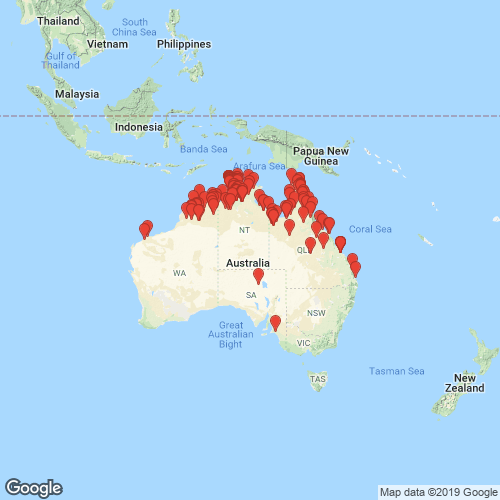
6 available nominal species synonyms (7 total synonyms) Recent Taxonomic OpinionsVelesunio angasi — Graf & Cummings (2007), Hoeh et al. (2009), Bogan (2010), Zieritz et al. (2013), Walker et al. (2014), Zieritz et al. (2015), Santos-Neto et al. (2016), Graf & Cummings (2021), Campbell & Lydeard (2026) RangeQueensland west to Western Australia, northern Australia. Map of Georeferenced Specimens
Australia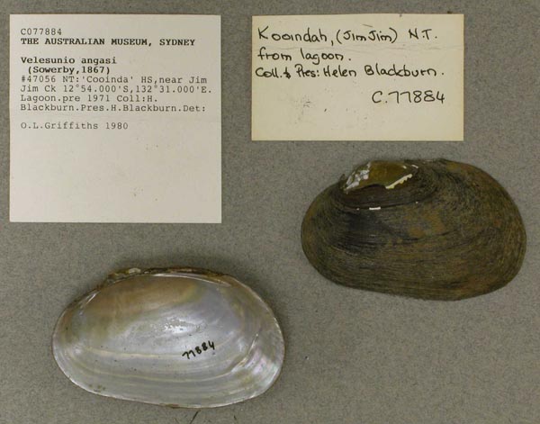
AMS_77884
"Cooinda" HS, near Jim Jim Ck (Lagoon), Northern Territory, Australia [-12.9, 132.517 ± 10 km]
| 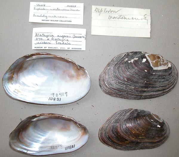
UMMZ_111821
[no locality available - Australia]
| 
UMMZ_111821
[no locality available - Australia]
| 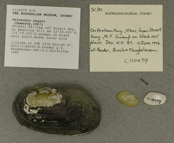
AMS_110479
15 km off Stuart Hwy, on Beatrice Hill Rd (Arnhem Hwy?), swamps on black soil plain (Muddy water with lillies), Northern Territory, Australia [-12.65, 131.317 ± 10 km]
| 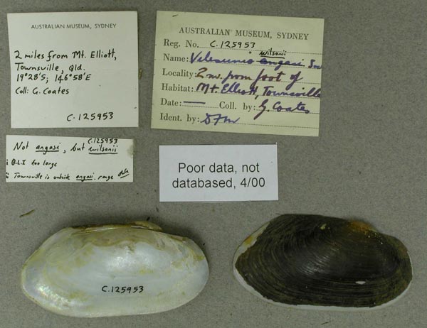
AMS_125953
2 mi from foot of Mt. Elliot, Townsville, Queensland
| 
AMS_113751
20 km E of "Beswick" Station, Chambers R, Dollum Dollum Waterhole (In muddy banks in shallow water), Northern Territory, Australia [-14.533, 133.275 ± 10 km]
| 
AMS_378431
26.8 km N of Frog Hollow, small creek crossing Northern Hwy (Sandy bottom with some rocks), Western Australia, Australia [-17.083, 128.183 ± 10 km]
| 
AMS_114689
32.5km W of Victoria R, Crawford Ck crossing Timber Ck - Top Springs Rd., Northern Territory, Australia [-16.263, 130.847 ± 1 km]
| 
AMS_125960
32km (=20 miles) S of Katherine, King River, Northern Territory, Australia [-14.703, 132.067 ± 10 km]
| 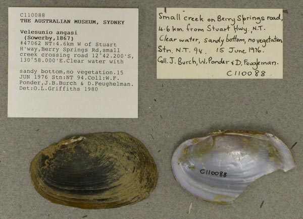
AMS_110088
4.6km W of Stuart H'way, Berry Springs Rd, small creek crossing road (Clear water with sandy bottom, no vegetation), Northern Territory, Australia [-12.703, 130.967 ± 10 km]
| 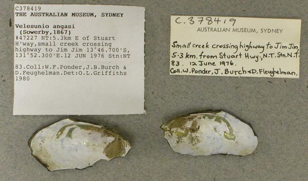
AMS_378419
5.3km E of Stuart H'way, small creek crossing highway to Jim Jim, Northern Territory, Australia [-13.778, 131.872 ± 1 km]
| 
UMMZ_111811
50 mi S Port Darwin, North Territory, Australia
| 
UMMZ_111811
50 mi S Port Darwin, North Territory, Australia
| 
AMS_114697
6.3 km E of Timber Creek township, branch of Timber Ck crossing Victoria H'way, Northern Territory, Australia [-15.742, 130.558 ± 10 km]
| 
AMS_126396
Abraham Billabong, Northern Territory, Australia [-14.9, 133.083 ± 10 km]
| 
BMNH_92-1-29-195
Adelaide River, N. Australia
| 
AMS_61861
Adels Grove, Lawn Hill Ck, 60mls SW of Burketown, Queensland, Australia [-18.683, 138.533 ± 10 km]
| 
BMNH_1906-10-22-1-2
Alexandria, N. Territory of South Australia
| 
AMS_381774
Alice River at Barcaldine, Queensland, Australia [-23.55, 145.283 ± 10 km]
| 
AMS_126262
Approx 22 km N of Ayr, East Barratta Ck, Queensland, Australia [-19.567, 147.217 ± 10 km]
| 
AMS_110464
Approx 23km from Stuart H'way on Mt Mable Rd, trib of Finniss R South (Clear water with sand & rock bottom), Northern Territory, Australia [-13.067, 130.867 ± 10 km]
| 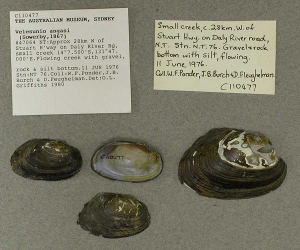
AMS_110477
Approx 28km W of Stuart H'way on Daly River Rd, small creek (Flowing creek with gravel, rock & silt bottom), Northern Territory, Australia [-14.125, 131.783 ± 10 km]
| 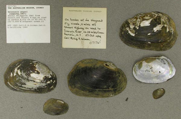
AMS_71741
Approx 38ml from Darwin, off Stuart H'way, on road to Darwin R, Fly Ck. (Stagnant creek), Northern Territory, Australia [-12.7, 131.083 ± 10 km]
| 
AMNH_96009
Archer River, Wenlock Crossing, North Queensland, Australia
| 
ZMB_38066
Arnheim’s Land, N Australia
| 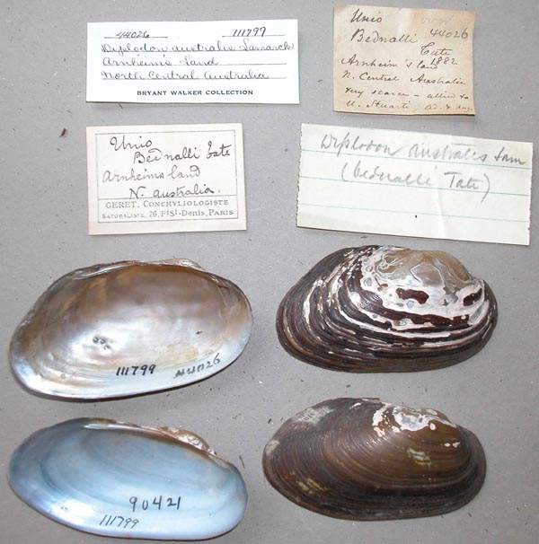
UMMZ_111799
Arnheims land, North Central Australia
| 
UMMZ_111799
Arnheims land, North Central Australia
| 
ZMB_19083
Arnheimsland, N. Australia
| 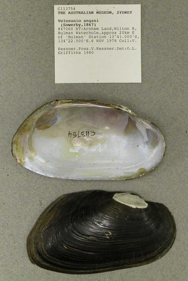
AMS_113754
Arnhem Land, Wilton R, Bulman Waterhole, approx 20km E of "Bulman" Station, Northern Territory, Australia [-13.683, 134.375 ± 1 km]
| 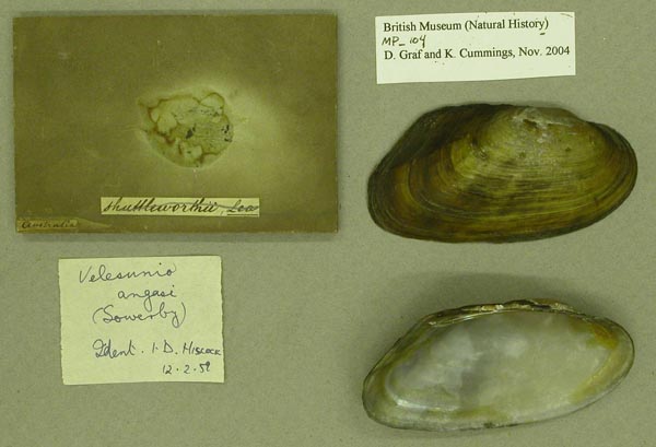
BMNH_MP_104
Australia
| 
AMNH_30905
Australia
| 
ANSP_125856
Australia
| 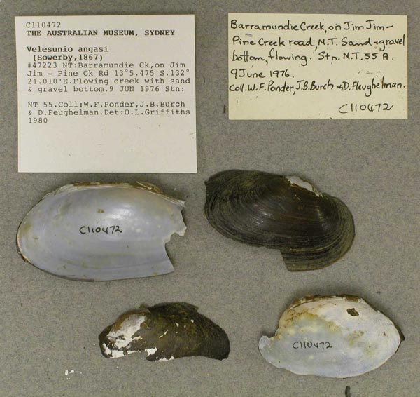
AMS_110472
Barramundie Ck, on Jim Jim - Pine Ck Rd (Flowing creek with sand & gravel bottom, leaves & lillies), Northern Territory, Australia [-13.091, 132.35 ± 10 km]
| 
AMS_61883
Batavia River (=Wenlock River), Queensland, Australia [-12.283, 142.083 ± 100 km]
| 
MCZ_190272
Batavia River, Wenlock Downs, North Queensland, Australia
| 
AMS_126454
Berry Springs, 55 km S of Darwin, Northern Territory, Australia [-12.7, 130.967 ± 10 km]
| 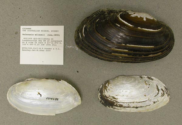
AMS_314499
Billabong on Landsborough Hwy NW of Longreach on N side of Darr R, Queensland, Australia [-23.215, 144.075 ± 100 m]
| 
AMS_314446
Billabong, 5km along rd to Larrys Lake Yard on W side of road off Top Springs Rd (5km N of Buchanan Hwy, E of Victoria R) (see data sheet), Northern Territory, Australia [-16.308, 131.162 ± 100 m]
| 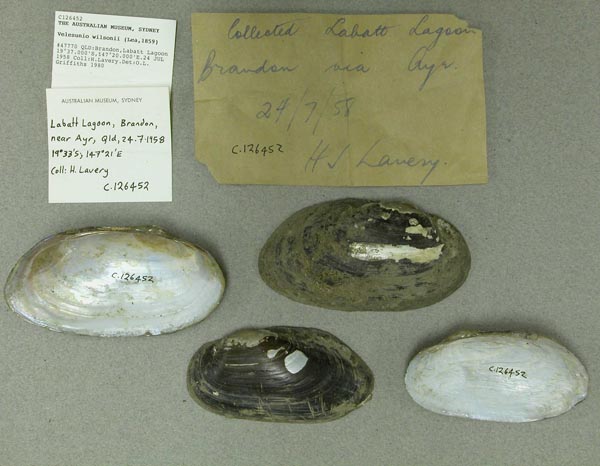
AMS_126452
Brandon, Labatt Lagoon, Queensland, Australia [-19.617, 147.333 ± 1 km]
| 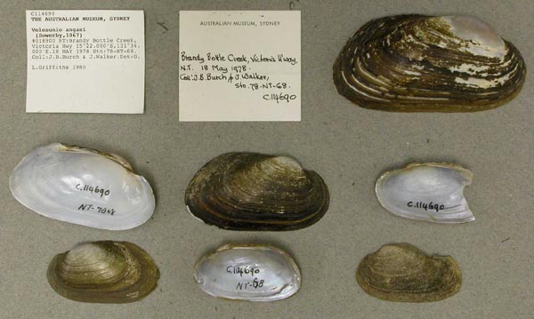
AMS_114690
Brandy Bottle Creek, Victoria Hwy, Northern Territory, Australia [-15.316, 131.559 ± 1 km]
| 
BMNH_58-3-19-135
Brisbane River
| 
FMNH_199573
Brooking Creek, Brooking Gorge entrance, W of Fitzroy Crossing, Western Australia
| 
AMS_400902
Bullhead Ck on Peninsula Development Rd (Amongst stones in flowing section), Queensland, Australia [-15.89, 144.857 ± 100 m]
| 
BMNH_MP_363
Burke River, South Austrtalia
| 
BMNH_MP_363
Burke River, South Austrtalia
| 
AMS_103996
Cadell R at Cadell R Rd, S of Boucaut Bay (Wide, shallow, good flow, rock sand, gravel & weeds. In sand), Northern Territory, Australia [-12.292, 134.425 ± 10 km]
| 
AMS_314456
Calvert R. just below junction with Bluey Ck, W. Gulf of Carpentaria, Northern Territory, Australia [-16.936, 137.359 ± 100 m]
| 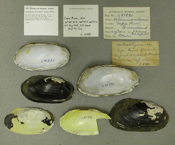
AMS_61881
Cape River, Queensland, Australia [-21, 146.425 ± 100 km]
| 
AMS_125956
Cape York Pen, E coast, Rocky R, top Rocky crossing (Sand & rock bottom), Queensland, Australia [-13.817, 143.45 ± 1 km]
| 
AMS_125954
Cape York Pen, S end of Embley Range, between Chester & Nesbit R, Billygoat Ck (Sand & rock bottom), Queensland, Australia [-13.583, 143.5 ± 10 km]
| 
AMS_125958
Cape York Pen, S end of Embley Range, between Chester R & Rocky R, Scrubby Ck (Sand & rock bottom), Queensland, Australia [-13.75, 143.467 ± 10 km]
| 
AMS_125955
Cape York Peninsula, "Silver Plains" Stn, Queensland, Australia [-13.979, 143.546 ± 10 km]
| 
AMS_125957
Cape York, Iron Range, Claudie River near Mt Lamond, Queensland, Australia [-12.717, 143.288 ± 1 km]
| 
BMNH_MP_429
Central Australia
| 
AMS_126042
Clermont, Queensland, Australia [-22.833, 147.633 ± 10 km]
| 
AMS_385747
Codroy Ck, between Musgrave Stn and Hann River, Queensland, Australia [-15.16, 143.834 ± 100 m]
| 
MCZ_186734
Coen, Cape York, Queensland, Australia
| 
AMS_314489
Coomalie Ck, at rest area on Stuart Hwy (rock washings, weed and roots), Northern Territory, Australia [-13.015, 131.123 ± 100 m]
| 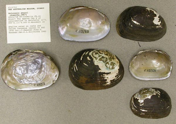
AMS_113753
Coomalie Ck, on Stuart Hwy approx. 3km S of intersection to Batchelor (Abundant in shallow water on rocks and fallen Pandanus leaves), Northern Territory, Australia [-13.083, 131.1 ± 10 km]
| 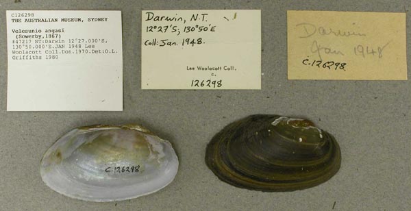
AMS_126298
Darwin, Northern Territory, Australia [-12.45, 130.833 ± 10 km]
| 
DMNH_51610
Didgeridoo Lagoon, near Ayr, North Queensland, Australia
| 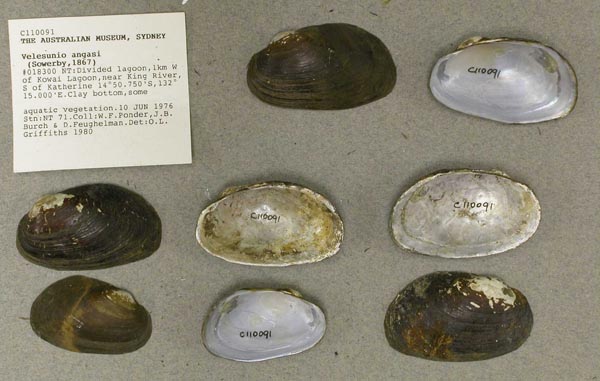
AMS_110091
Divided lagoon, 1km W of Kowai Lagoon, near King River, S of Katherine (Clay bottom, some aquatic vegetation), Northern Territory, Australia [-14.846, 132.25 ± 10 km]
| 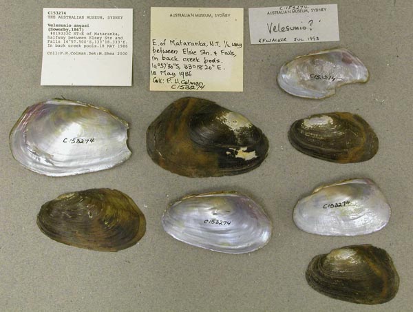
AMS_153274
E of Mataranka, halfway between Elsey Stn and Falls (In back creek pools), Northern Territory, Australia [-14.958, 133.306 ± 1 km]
| 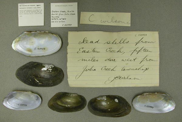
AMS_125933
Eastern Ck, 22km W of Julia Ck township, Bruce Hwy, Queensland, Australia [-20.65, 141.533 ± 1 km]
| 
AMS_126259
Einasleigh, Queensland, Australia [-18.512, 144.102 ± 10 km]
| 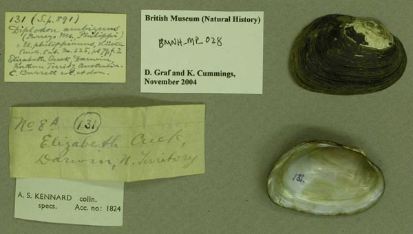
BMNH_MP_028
Elizabeth Creek, Darwin, Northern Territory, Australia
| 
AMS_111358
Elsey Falls, Roper River, SE of Katherine (Sandy bottom), Northern Territory, Australia [-14.918, 133.118 ± 1 km]
| 
AMS_126320
Fitzmaurice River, Northern Territory, Australia [-14.883, 130.283 ± 100 km]
| 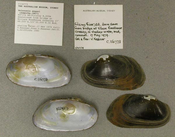
AMS_116773
Fitzroy R, 200m downstream from bridge at Willare Roadhouse crossing (In mud, shallow water), Western Australia, Australia [-17.733, 123.5 ± 1 km]
| 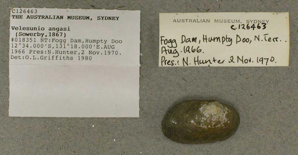
AMS_126463
Fogg Dam, Humpty Doo, Northern Territory, Australia [-12.567, 131.3 ± 10 km]
| 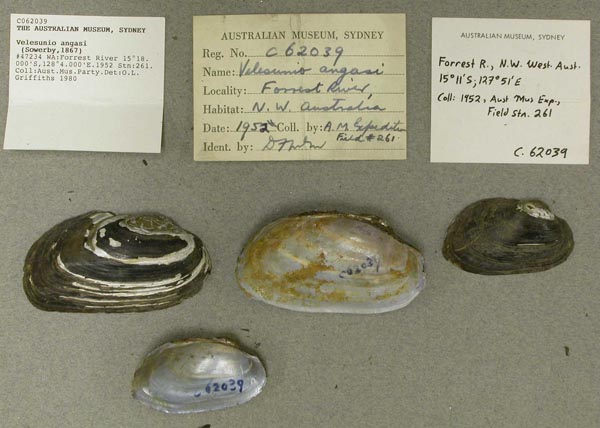
AMS_62039
Forrest River, Western Australia, Australia [-15.3, 128.067]
| 
AMS_155115
Fortescue R, above North West Coastal Hwy Rd bridge, SW of Dampier, Pilbara, Western Australia, Australia [-21.3, 116.133 ± 1 km]
| 
AMS_99367
Frogmore Lagoon, Rockhampton, Queensland, Australia [-23.446, 150.539 ± 1 km]
| 
AMS_99367
Frogmore Lagoon, Rockhampton, Queensland, Australia [-23.446, 150.539 ± 1 km]
| 
UMMZ_60220
Glenelg River, Kimberly Division, Western Australia
| 
UMMZ_60220
Glenelg River, Kimberly Division, Western Australia
| 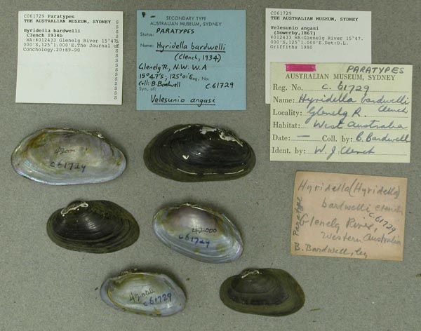
AMS_61729
Glenelg River, Western Australia, Australia [-15.783, 125.017 > ± 100 km]
| 
AMS_155880
Gregory R at Riversleigh crossing, Queensland, Australia [-19.033, 138.733 ± 1 km]
| 
AMS_125952
Gregory R, Proserpine District, Queensland, Australia [-20.233, 148.5]
| 
AMS_327802B
Gregory River on Riversleigh - Lawn Hill Rd (on substrate and on weed (Thiarids), amongst roots and substrate in fast flowing channels (Mussels), in gravel and sand in fast channels), Queensland, Australia [-19.018, 138.726 ± 100 m]
| 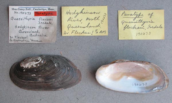
MCZ_190273
Hodgkinson River, Queensland, Australia
| 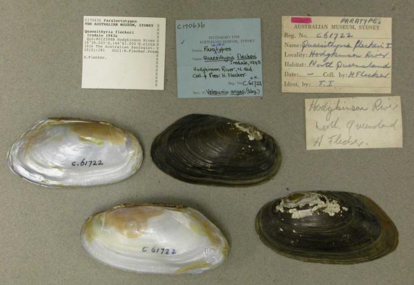
AMS_170636
Hodgkinson River, Queensland, Australia [-16.65, 144.683 ± 100 km]
| 
AMS_126368
Hodgkinson River, Queensland, Australia [-16.65, 144.683 ± 100 km]
| 
AMS_126377
Hodgkinson River, Queensland, Australia [-16.65, 144.683 ± 100 km]
| 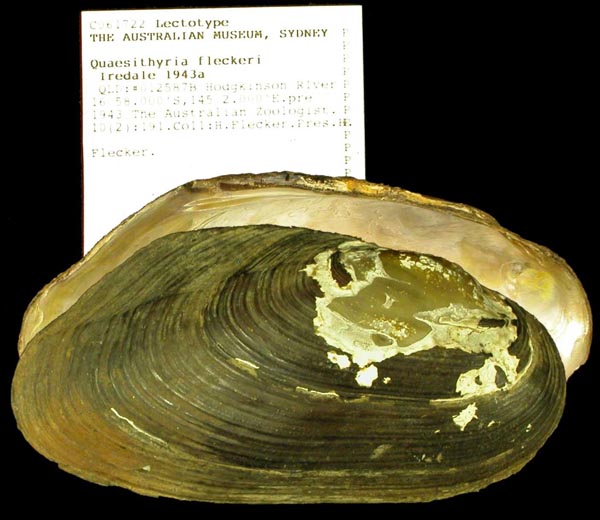
AMS_61722
Hodgkinson River, Queensland, Australia [-16.967, 145.033 ± 100 km]
| 
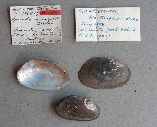
MCZ_196597
Holmes Creek, 12 mi E. Darwin, Northern Territory, Australia
| 
MCZ_196597
Holmes Creek, 12 mi E. Darwin, Northern Territory, Australia
| 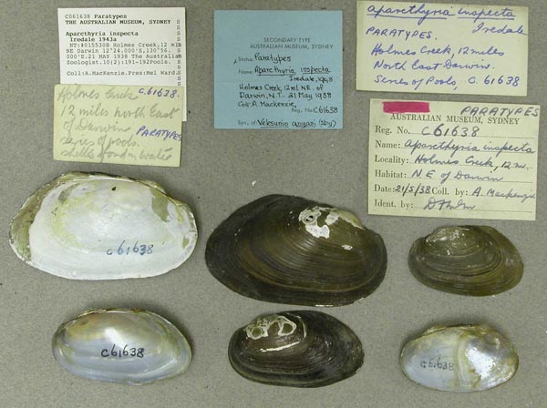
AMS_61638
Holmes Creek, 12 mls NE Darwin (Pools), Northern Territory, Australia [-12.4, 130.933 ± 10 km]
| 
AMS_61637
Holmes Creek, 12 mls NE Darwin (Series of pools), Northern Territory, Australia [-12.4, 130.933 ± 10 km]
| 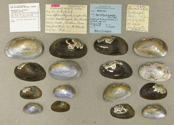
AMS_61639
Howard Ck, Koolpinyah Stn., Northern Territory, Australia [-12.383, 131.083 ± 10 km]
| 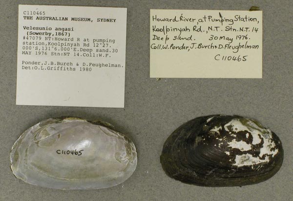
AMS_110465
Howard R at pumping station, Koolpinyah Rd (Deep sand), Northern Territory, Australia [-12.45, 131.1 ± 10 km]
| 
BMNH_MP_409
Howard Spring, near Darwin, N.T. Australia
| 
AMS_76407
Howard Springs, ca 18mls SE of Darwin, Northern Territory, Australia [-12.458, 131.05 ± 1 km]
| 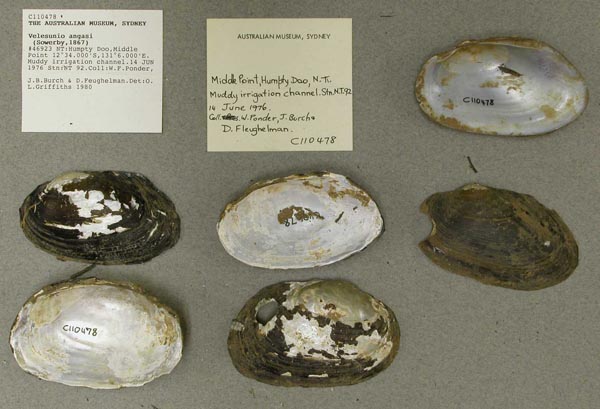
AMS_110478
Humpty Doo, Middle Point (Steep sided man-made channel with grass, reeds, lily pads & muddy bottom), Northern Territory, Australia [-12.567, 131.1 ± 10 km]
| 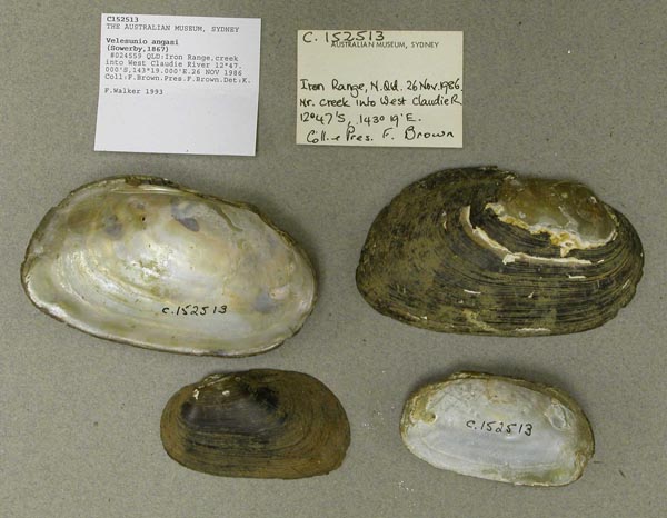
AMS_152513
Iron Range, creek into West Claudie River, Queensland, Australia [-12.783, 143.317 ± 1 km]
| 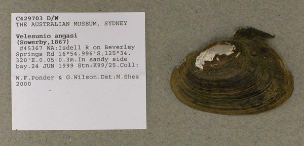
AMS_429703
Isdell R on Beverley Springs Rd (In sandy side bay), Western Australia, Australia [-16.917, 125.572 ± 100 m]
| 
AMS_168984
Isdell Ranges, Bells Gorge Falls, Western Australia, Australia [-16.975, 125.192 ± 1 km]
| 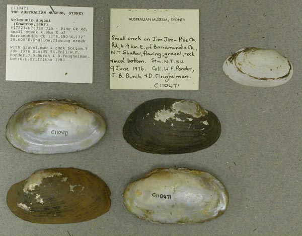
AMS_110471
Jim Jim - Pine Ck Rd, small creek 4.9km E of Barramundie Ck (Shallow, flowing creek with gravel, mud & rock bottom), Northern Territory, Australia [-13.141, 132.477 ± 1 km]
| 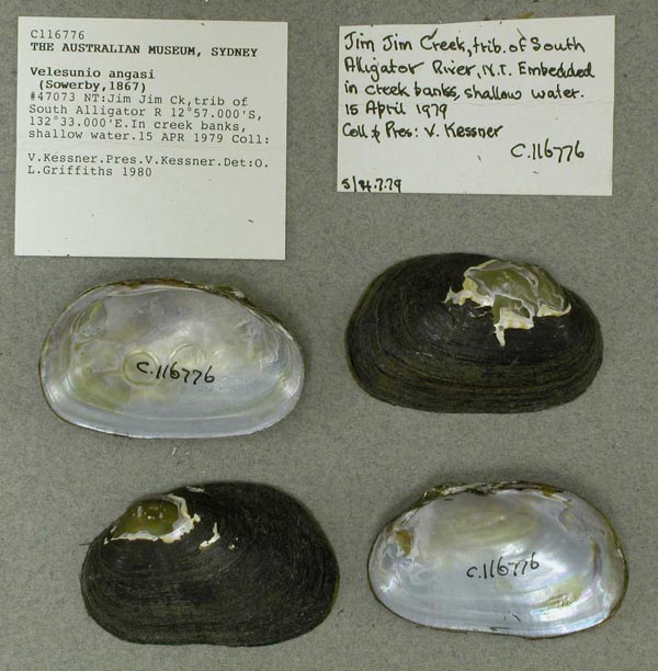
AMS_116776
Jim Jim Ck, trib of South Alligator R (In creek banks, shallow water), Northern Territory, Australia [-12.95, 132.55 ± 10 km]
| 
USNM_853941
Jim Jim Creek, Northern Territory, Australia
| 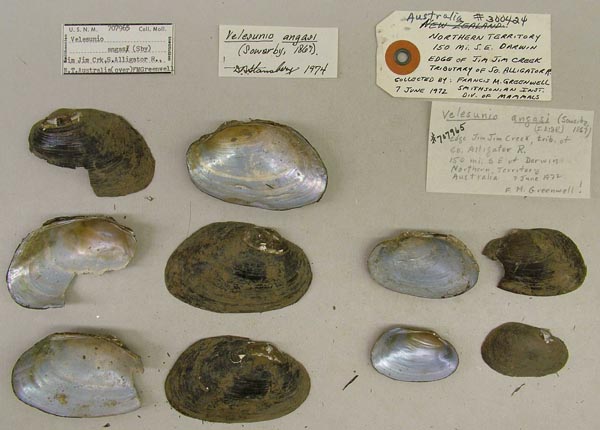
USNM_707965
Jim Jim Creek, trib. of South Alligator R., 150 mi SE Darwin, Northern Territory, Australia
| 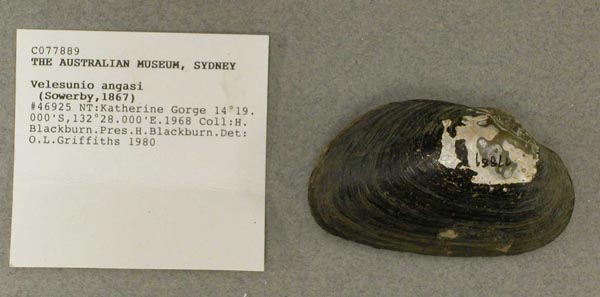
AMS_77889
Katherine Gorge, Northern Territory, Australia [-14.317, 132.467 ± 10 km]
| 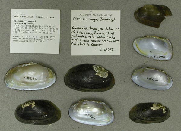
AMS_113755
Katherine River, ca 20km NW of Eva Valley Station, NE of Katherine (Under rocks in shallow water), Northern Territory, Australia [-14.083, 132.725 ± 10 km]
| 
AMS_3445
Kensington Downs, Queensland, Australia [-22.5, 144.183 ± 10 km]
| 
AMS_163056
Kimberley, Lennard R Gorge, river bed beyond upper pool. (In seepage & flow through boulders & some small pools.), Western Australia, Australia [-17.183, 125.2 ± 1 km]
| 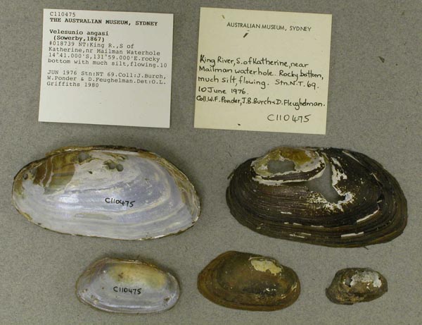
AMS_110475
King R., S of Katherine, nr Mailman Waterhole (rocky bottom with much silt, flowing), Northern Territory, Australia [-14.817, 132.217 ± 10 km]
| 
AMS_61640
Koolpinyah Station, Bambers Jungle Ck, Northern Territory, Australia [-12.383, 131.083 ± 10 km]
| 
AMS_110476
Kowai Lagoon, S of Katherine, nr King River (shallow pond, silty stony bottom), Northern Territory, Australia [-14.85, 132.25 ± 10 km]
| 
UMMZ_50659
Kuranda, North Queensland, Australia
| 
UMMZ_50659
Kuranda, North Queensland, Australia
| 
MCZ_MP.240
lagoon near Margaret, Australia
| 
ZMB_9082
Lagoon, Mount Margaret, Australia
| 
AMS_61641
Lake Deane,40-45 mls from Darwin, Northern Territory, Australia [-12.733, 131.017 ± 10 km]
| 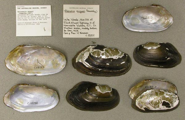
AMS_113752
Lake Woods, 11km SW of Elliot on Stuart Hwy (Shallow water with muddy bottom), Northern Territory, Australia [-17.817, 133.55 ± 10 km]
| 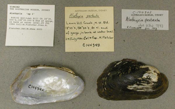
AMS_144342
Lawn Hill Ck (End of gorge, in bank at water level), Queensland, Australia [-18.583, 138.583 ± 10 km]
| 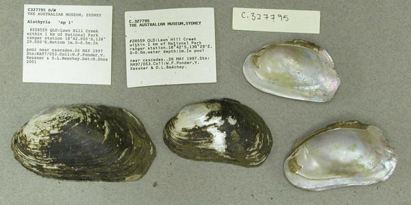
AMS_327795
Lawn Hill Creek within 1 km of National Park ranger station (In pool near cascades), Queensland, Australia [-18.7, 138.483 ± 100 m]
| 
AMS_61864
Lennard River, Western Australia, Australia [-17.4, 124.5]
| 
AMS_5600
Longreach, Queensland, Australia [-23.25, 144.167 ± 10 km]
| 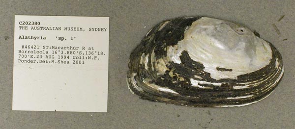
AMS_202380
Macarthur R at Borroloola, Northern Territory, Australia [-16.065, 136.312 ± 100 m]
| 
AMS_125934
Mary River, Gympie, Queensland, Australia [-26.183, 152.667 ± 10 km]
| 
MCZ_186551
McKinley River, Arnheimland, Northern Territory, Australia
| 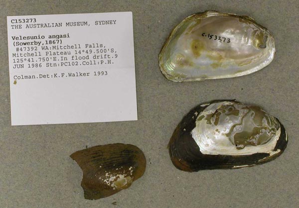
AMS_153273
Mitchell Falls, Mitchell Plateau (In flood drift), Western Australia, Australia [-14.825, 125.696 ± 1 km]
| 
AMS_420364
Mitchell River crossing, Queensland, Australia [-16.375, 143.976 ± 100 m]
| 
AMS_327809
Mitchell River NNE of Dunbar Stn, Queensland, Australia [-15.964, 142.423 ± 100 m]
| 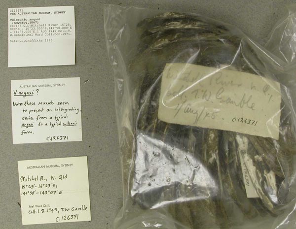
AMS_126371
Mitchell River, Queensland, Australia [-15.417, 141.967 ± 100 km]
| 
AMS_126461
Moulamen Water, near Upper Liveringa, Fitzroy Valley, Western Australia, Australia [-17.967, 124.317 ± 10 km]
| 
INHS_11429
Murray Lagoon, Rockhampton, Queensland, Australia
| 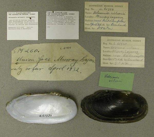
AMS_61730
Murray Lagoons, near Rockhampton, Queensland, Australia [-23.367, 150.517 ± 1 km]
| 
AMS_62164
Murray Lagoons, Rockhampton, Queensland, Australia [-23.367, 150.517 ± 1 km]
| 
AMS_62164
Murray Lagoons, Rockhampton, Queensland, Australia [-23.367, 150.517 ± 1 km]
| 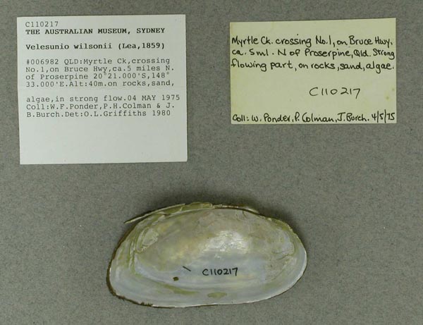
AMS_110217
Myrtle Ck, crossing No 1, on Bruce Hwy, ca. 5mls N of Proserpine (on rocks, sand, algae, in strong flow), Queensland, Australia [-20.35, 148.55 ± 10 km]
| 
AMS_156347
NE Arnhem Land, edge of Mirmgadgja, Arafura Swamp, Bapal, Northern Territory, Australia [-12.65, 135.2 ± 10 km]
| 
AMS_156346
NE Arnhem Land, edge of Mirmgadgja, Arafura Swamp, Bapal, Northern Territory, Australia [-12.65, 135.2 ± 10 km]
| 
AMS_168982
NE side of King Leopold Ranges, on trib of Bell Ck, Scotts Gorge, Western Australia, Australia [-17.082, 125.261 ± 1 km]
| 
BMNH_MP_123
near Port Darwin
| 
BMNH_MP_123
near Port Darwin
| 
ANSP_71732
near Port Darwin, N. Australia
| 
AMS_61731
Norman River (Lagoon near bar, across river), Queensland, Australia [-17.467, 140.5 ± 100 km]
| 
BMNH_MP_073
North Australia
| 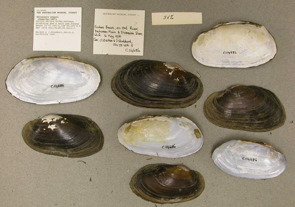
AMS_114686
Ord River, Forbes Beach, between diversion dam & main dam, Western Australia, Australia [-15.883, 128.767 ± 10 km]
| 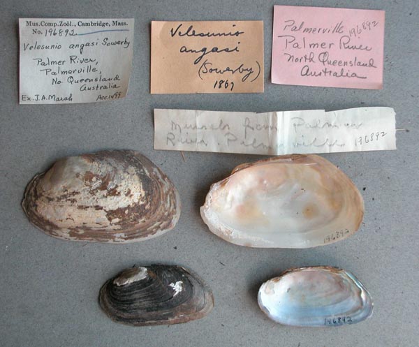
MCZ_196892
Palmer River, Palmerville, Northern Queensland, Australia
| 
AMS_155116
Pilbara Springs, Miaree Pool, S of Dampier, Western Australia, Australia [-20.854, 116.614 ± 1 km]
| 
AMS_110474
Pine Ck at Stuart H'way (Stone & gravel bottom), Northern Territory, Australia [-13.817, 131.817 ± 10 km]
| 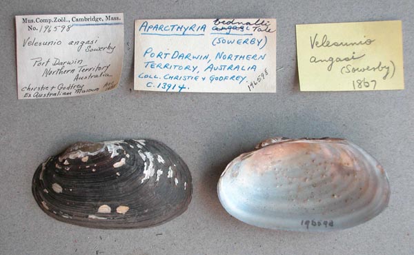
MCZ_196598
Port Darwin, Northern Territory, Australia
| 
AMS_13914
Port Darwin, Northern Territory, Australia [-12.467, 130.833 ± 10 km]
| 
DMNH_186566
Queensland, Australia
| 
AMS_419930
Robinson R. at road crossing, Northern Territory, Australia [-16.75, 137.983 ± 100 m]
| 
AMS_419946
Robinson River at Carpentaria Hwy (under large rocks), Northern Territory, Australia [-16.472, 137.049 ± 100 m]
| 
ANSP_125855
Rockhampton, N. Australia
| 
AMS_126355
Rockhampton, Queensland, Australia [-23.367, 150.533 ± 10 km]
| 
AMS_424686
Roper R at Roper Bar camping ground (On & under roots in shade at bank just above water), Northern Territory, Australia [-14.712, 134.513 ± 100 m]
| 
AMS_327784
Roper R at Roper Bar camping ground (On & under roots in shade at bank just above water), Northern Territory, Australia [-14.712, 134.513 ± 100 m]
| 
AMS_314478
Roper River at Roper Bar Crossing, Northern Territory, Australia [-14.716, 134.507 ± 1 km]
| 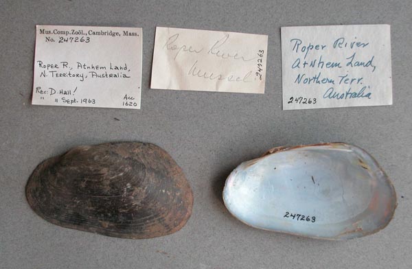
MCZ_247263
Roper River, Atnhem Land, N. Territory, Australia
| 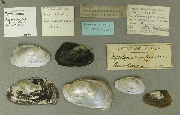
AMS_31560
Roper River, Northern Territory; 14°42’S, 134°05’E, Australia
| 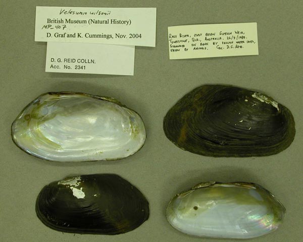
BMNH_MP_407
Ross River, just below Gleeson Weir, Townsville, Queensland, Australia
| 
AMS_327794
Running creek on Gregory Downs to Burketown Rd, 40km N of Gregory Downs and about 5km S of Almora Station, Queensland, Australia [-18.323, 139.264 ± 100 m]
| 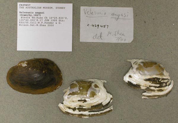
AMS_429457
Russ Ck, Western Australia, Australia [-16.497, 126.7 ± 10 km]
| 
AMS_62040
S of Charters Towers, on Gregory Developmental Rd, Cape R, Queensland, Australia [-21, 146.425 ± 10 km]
| 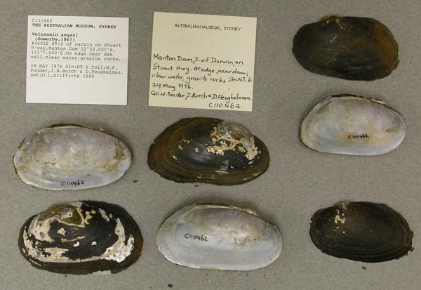
AMS_110462
S of Darwin on Stuart H'way, Manton Dam (On edge near dam wall, clear water, granite rocks), Northern Territory, Australia [-12.867, 131.117 ± 1 km]
| 
AMS_126453
S of Proserpine, Goorganga Ck, Queensland, Australia [-20.483, 148.533 ± 10 km]
| 
ANSP_71739
S. Australia
| 
AMS_385748
Sandy Ck crossing, on main road to Lakefield Ranger Stn (On edges of pool, in mud), Queensland, Australia [-15.093, 144.316 ± 100 m]
| 
AMS_110466
SE of Howard Springs (marshy area near creek), Northern Territory, Australia [-12.467, 131.05 ± 10 km]
| 
AMS_111359
SE of Katherine, on Roper Hwy before turnoff to Elsey Falls, unnamed ck., Northern Territory, Australia [-14.95, 133.333 ± 1 km]
| 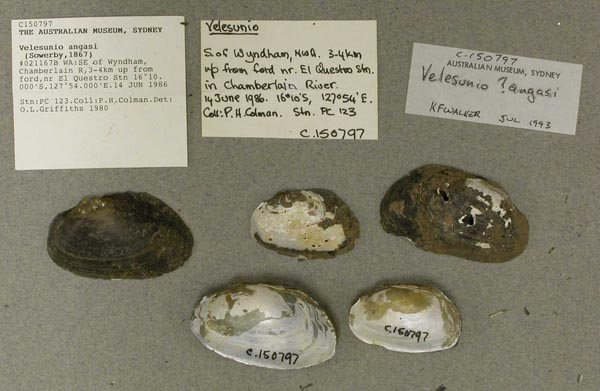
AMS_150797
SE of Wyndham, Chamberlain R, 3-4km up from ford, nr El Questro Stn, Western Australia, Australia [-16.167, 127.9 ± 1 km]
| 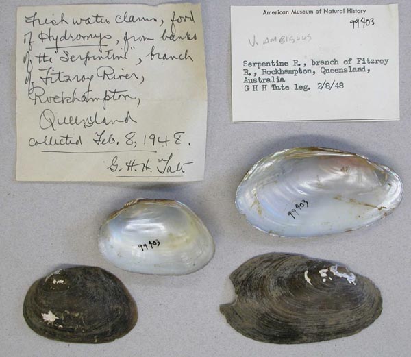
AMNH_99403
Serpentine River, branch of the Fitzroy River, Rockhampton, Queensland, Australia
| 
UMMZ_111886
Silver Valley, Australia
| 
UMMZ_111886
Silver Valley, Australia
| 
UMMZ_111886
Silver Valley, Australia
| 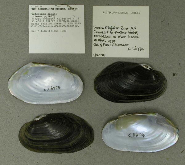
AMS_116774
South Alligator R (In creek banks, shallow water), Northern Territory, Australia [-12.557, 132.343 ± 10 km]
| 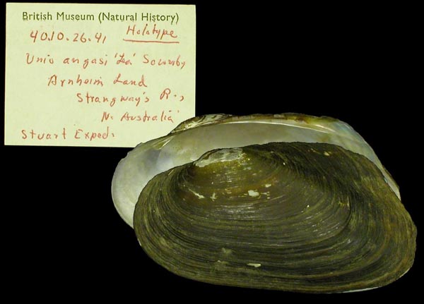
BMNH_70-10-26-41
Strangways River, Arnheim Land, North Australia
| 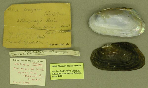
BMNH_70-10-26-41
Strangways River, Arnheim Land, North Australia
| 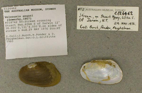
AMS_126462
stream crossing Stuart Hwy, 60km S of Darwin (on sides of stream in mud), Northern Territory, Australia [-12.737, 131.09 ± 10 km]
| 
AMS_117981
Townsville, Ross River (In dried mud, in banks), Queensland, Australia [-19.267, 146.817 ± 1 km]
| 
AMS_126328
Townsville, Ross River, Black Weir, Queensland, Australia [-19.267, 146.842 ± 1 km]
| 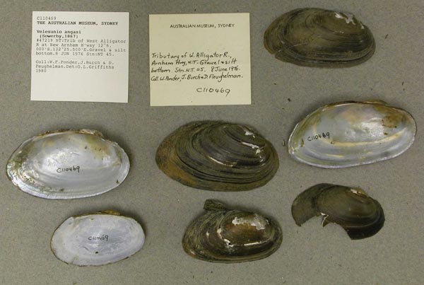
AMS_110469
Trib of West Alligator R at New Arnhem H'way (Gravel & silt bottom), Northern Territory, Australia [-12.1, 132.425 ± 1 km]
| 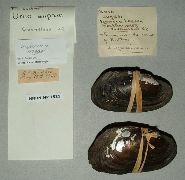
MNHN_MP_1531
Veppoon Lagoon, Rockhampton, Queensland, New Zealand
| 
AMS_110470
W branch of Nourlangie Ck, on road to Jim Jim (Sandy bottom), Northern Territory, Australia [-12.825, 132.742 ± 10 km]
| 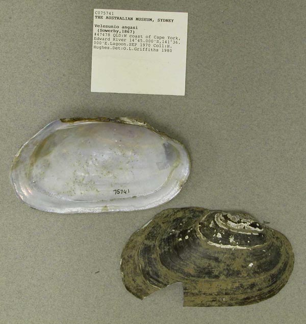
AMS_75741
W coast of Cape York, Edward River (Lagoon), Queensland, Australia [-14.75, 141.6 ± 100 km]
| 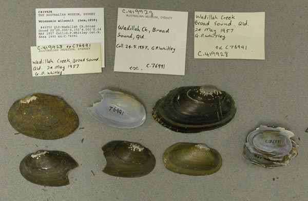
AMS_419928
Wadallah Ck, Broad Sound, Queensland, Australia [-22.417, 150.067 ± 100 km]
| 
AMS_327801
Waterhole and stream between Adels Grove and Lawn Hill Stn Homestead (On roots and substrate), Queensland, Australia [-18.652, 138.561 ± 100 m]
| 
AMS_419948
Waterhole and stream between Adels Grove and Lawn Hill Stn Homestead (On roots and substrate), Queensland, Australia [-18.652, 138.561 ± 100 m]
| 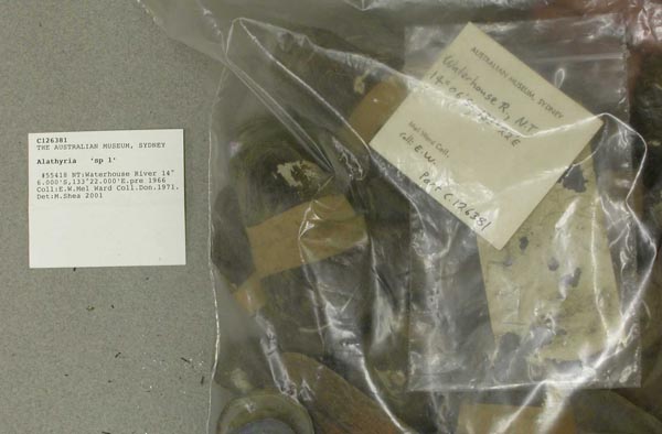
AMS_126381
Waterhouse River, Northern Territory, Australia [-14.1, 133.367 > ± 100 km]
| 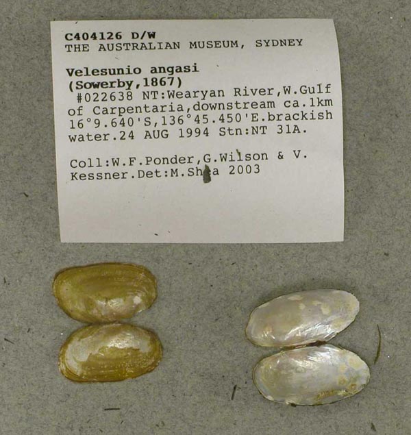
AMS_404126
Wearyan River, W. Gulf of Carpentaria, downstream ca. 1km (brackish water), Northern Territory, Australia [-16.161, 136.757 ± 10 km]
| 
AMS_61739
Wenlock Downs, Wenlock (Batavia) River, Queensland, Australia [-13.095, 142.942 ± 10 km]
| 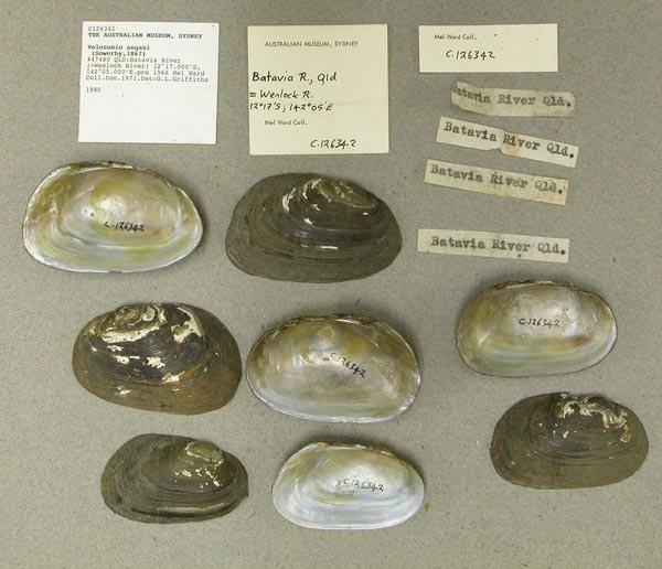
AMS_126342
Wenlock Downs, Wenlock (Batavia) River, Queensland, Australia [-13.095, 142.942 ± 10 km]
| 
AMS_126397
Wenlock Downs, Wenlock (Batavia) River, Queensland, Australia [-13.095, 142.942 ± 10 km]
| 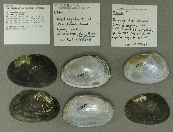
AMS_378371
West Alligator R at New Arnhem Hwy (Gravel bottom, no weed.), Northern Territory, Australia [-12.817, 132.167 ± 10 km]
| 
AMS_110468
West Alligator R at New Arnhem Hwy (Gravel bottom, no weed.), Northern Territory, Australia [-12.817, 132.167 ± 10 km]
| 
DMNH_186565
Western Australia
| 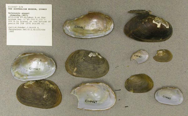
AMS_110467
Wildman R. at New Arnhem Hwy. (In gravel at the bottom of pools), Northern Territory, Australia [-12.825, 132.05 ± 1 km]
| 
AMS_62041
Wilson River, S of Wyndham, Western Australia, Australia [-16.633, 128.083 ± 100 km]
| 
AMS_56514
Yeppen Lagoon, near Rockhampton, Queensland, Australia [-23.417, 150.5 ± 10 km]
| 
AMS_118181
Yeppen, near Rockhampton, Murray Lagoon, Queensland, Australia [-23.417, 150.5 ± 10 km]
|
AMS_314450. 11 km from turnoff to Limestone Mill on track to Point Spring N of Ning Bing Ranges (along banks in shallow water), Western Australia, Australia [-15.389, 128.823 ± 100 m] AMS_427350. Adelaide R railway station dam (On dam bank), Northern Territory, Australia [-13.244, 131.112 ± 100 m] AMS_110463. Adelaide R, at Stuart Hwy, S of Darwin (Flowing river with sand & rock bottom), Northern Territory, Australia [-13.233, 131.1 ± 10 km] AMS_383522. Adelaide River at Adelaide River, Northern Territory, Australia [-13.25, 131.1 ± 10 km] AMS_430715. Adelaide River at Stuart Hwy, Northern Territory, Australia [-13.25, 131.1 ± 10 km] AMS_423847. Ashburton River, 500m E of NW Coastal Hwy, Western Australia, Australia [-22.567, 115.533 ± 1 km] AMS_121361. Barlee Range, Kookhabinna Gorge, Kookhabinna Ck, Western Australia, Australia [-23.083, 116.033 ± 10 km] AMS_125985. Barlee Range, Kookhabinna Gorge, Kookhabinna Ck, Western Australia, Australia [-23.083, 116.033 ± 10 km] AMS_420526. Barramundi Gorge Pool, 1km N of Pool, Northern Territory, Australia [-13.306, 132.434 ± 100 m] AMS_327763. Batten Creek (under stones and on roots), Northern Territory, Australia [-16.301, 135.707 ± 100 m] AMS_420537. Behind Bauhinia Downs Hmst, W. of Borroloola (warm spring, large plunge pool below junction of warm and cold spring), Northern Territory, Australia [-16.217, 135.46 ± 1 km] AMS_202363. Bell Ck (Mainly under large rocks in gravel), Western Australia, Australia [-17.171, 125.36 ± 100 m] AMS_427158. Berry Ck, Stuart Hwy, S of Darwin (In creek bed), Northern Territory, Australia [-12.735, 131.09 ± 100 m] AMS_383521. Billabong 3.5km S of NA97/049 (on edges), Queensland, Australia [-18.331, 138.493 ± 100 m] AMS_404123. Billabong above Tully Inlet, W. of Mornington Is., Gulf of Carpentaria (amongst weed & macrophytes), Queensland, Australia [-16.762, 138.149 ± 100 m] AMS_314467. Billabong at side of Delamere Rd, ca. 37km S of Victoria Hwy (muddy substrate), Northern Territory, Australia [-15.582, 131.653 ± 100 m] AMS_404124. Billabong at side of Victoria Hwy between Timber Creek township and WA border (On mud), Northern Territory, Australia [-15.753, 130.044 ± 100 m] AMS_314496. Billabong at side of Victoria Hwy between Timber Creek township and WA border (On mud), Northern Territory, Australia [-15.753, 130.044 ± 100 m] AMS_424685. Billabong beside Norman R at Gulf Developmental Rd (Amongst weed and on mud), Queensland, Australia [-17.857, 141.135 ± 100 m] AMS_327361. Billabong by airstrip, Escott, near Burketown, Queensland, Australia [-17.729, 139.411 ± 100 m] AMS_327765. Billabong on Burke Development Road, NW of Marlborough Yard (On weed), Queensland, Australia [-16.091, 142.686 ± 100 m] AMS_404125. Bing Bong Station, W. Gulf of Carpentaria (Upper end of mangrove channel), Northern Territory, Australia [-15.627, 136.342 ± 1 km] AMS_424664. Bing Bong Station, W. Gulf of Carpentaria (waterhole), Northern Territory, Australia [-15.643, 136.361 ± 100 m] AMS_404117. Black Jungle Springs (elongate spring fed pool), Northern Territory, Australia [-13.05, 132.164 ± 1 km] AMS_314495. Black Jungle Springs (elongate spring fed pool), Northern Territory, Australia [-13.05, 132.164 ± 1 km] AMS_422495. Black soil plain, S of S Alligator R, Arnhem Hwy (Marshy open area), Northern Territory, Australia [-12.583, 132.45 ± 100 km] AMS_404121. Brannigan Ck at Karumba to Normanton Rd (side channel with waterholes), Queensland, Australia [-17.478, 141.177 ± 100 m] AMS_404118. Bullock Head Yard, E of Devils Gate ca. 14km (on weed and substrate), Queensland, Australia [-17.412, 138.482 ± 100 m] AMS_314493. ca. 33km S Adelaide River (township) at waterhole on side of Stuart Hwy (dried up waterhole, dead animals in / on substrate), Northern Territory, Australia [-13.433, 131.317 ± 10 km] AMS_314484. ca. 7km S. of Adelaide River along Stuart H'way. (In muddy pool alongside road), Northern Territory, Australia [-13.251, 131.108 ± 1 km] AMS_420527. Calvert River crossing on Carpentaria Hwy (under stone in flowing water and in large pools on surface of Pandanus leaves, under roots, etc.), Northern Territory, Australia [-16.934, 137.361 ± 100 m] AMS_327368. Clark Ck, at Burke Developmental Rd (in sandy pools [Mussels]), Queensland, Australia [-16.44, 142.083 ± 100 m] AMS_327369. Clarks Lagoon, Dunbar Stn on Burke Dev Rd (on weed), Queensland, Australia [-16.017, 142.417 ± 100 m] AMS_424666. Coomalie Ck, at rest area on Stuart Hwy (rock washings, weed and roots), Northern Territory, Australia [-13.015, 131.123 ± 100 m] AMS_422496. Corndorl (=Corndohl) Waterhole, Magela Ck system, E Alligator R, Northern Territory, Australia [-12.633, 132.883 ± 1 km] AMS_314482. Cox River, W. Gulf of Carpentaria, Northern Territory, Australia [-15.325, 135.344 ± 100 m] AMS_314480. creek at side of rd out to Limestone Gorge, Gregory National Park (under stones), Northern Territory, Australia [-16.018, 130.462 ± 100 m] AMS_413024. Culdara Lagoon, Woologorang Stn (on weed), Queensland, Australia [-17.192, 138.071 ± 100 m] AMS_422509. Cullen R., on hwy between Pine Creek & Katherine, Northern Territory, Australia [-14.067, 131.933 ± 100 km] AMS_424683. Dam off side rd off Delamere Rd, ca. 35km S of Victoria Hwy (see data sheet), Northern Territory, Australia [-15.585, 131.653 ± 100 m] AMS_314500. Dingo Springs Ck, W of Victoria R on Victoria Hwy, Northern Territory, Australia [-15.733, 130.56 ± 100 m] AMS_202353. Drysdale R (In sand), Western Australia, Australia [-14.45, 126.855 ± 100 m] AMS_429705. Drysdale R on Kalumburu Rd, Western Australia, Australia [-14.686, 126.377 ± 100 m] AMS_338595. Duck Pond, nr Flying Fox Station (on mud near edges), Northern Territory, Australia [-14.852, 134 ± 100 m] AMS_371682. Dunham R at Great Northern Hwy crossing (Under rocks in large pool), Western Australia, Australia [-16.156, 128.366 ± 100 m] AMS_427154. Dunham R on Great Northern Hwy, Western Australia, Australia [-16.154, 128.367 ± 100 m] AMS_371651. East Baines R at Bullita camping area, Gregory Nat Park (Attached to substrate beneath rocks), Northern Territory, Australia [-16.114, 130.421 ± 100 m] AMS_422500. Elizabeth R, 25 miles inland from Darwin, Northern Territory, Australia [-12.533, 131 ± 100 km] AMS_110460. Elizabeth R, at Stuart Hwy (Clear water, gravel bottom), Northern Territory, Australia [-12.533, 131 ± 10 km] AMS_404113. Elsey Cemetery (Along edges of large drying pond in soft mud and grass), Northern Territory, Australia [-15.085, 133.04 ± 100 m] AMS_371695. Elsey Cemetery (On & in mud & on green algae), Northern Territory, Australia [-15.086, 133.124 ± 100 m] AMS_420523. Elsey Falls at Roper River (Main river, mostly on roots along edge), Northern Territory, Australia [-14.918, 133.118 ± 100 m] AMS_427150. Fitzroy R on Derby Hwy (In pools, on roots, leaves, bark, etc.), Western Australia, Australia [-17.734, 123.648 ± 100 m] AMS_422531. Geikie Gorge, Fitzroy River (along banks), Western Australia, Australia [-18.083, 125.717 > ± 100 km] AMS_420538. Gilbert River on Burke Developmental Rd (in sand), Queensland, Australia [-17.169, 141.767 ± 100 m] AMS_327802. Gregory River on Riversleigh - Lawn Hill Rd (on substrate and on weed (Thiarids), amongst roots and substrate in fast flowing channels (Mussels), in gravel and sand in fast channels), Queensland, Australia [-19.018, 138.726 ± 100 m] AMS_202188. Grotto Ck, pool under bridge (Under rocks in pool), Western Australia, Australia [-15.717, 128.266 ± 100 m] AMS_386532. Hann River crossing, Lakefield NP, Queensland, Australia [-14.766, 144.079 ± 100 m] AMS_327370. Hodgson R at Rocky Bar Crossing (on surface of rocks in pools), Northern Territory, Australia [-14.895, 134.549 ± 100 m] AMS_430708. Howard Springs, 37km S of Darwin, Northern Territory, Australia [-12.458, 131.05 ± 1 km] AMS_110090. Howard Springs, 6km E of Stuart Hwy, Weir (Clear water, weeds, muddy bottom), Northern Territory, Australia [-12.458, 131.05 ± 1 km] AMS_422530. Iron Range, creek into West Claudie River, Queensland, Australia [-12.783, 143.317 ± 1 km] AMS_422505. Jim Jim Ck, on Jim Jim Rd, Northern Territory, Australia [-12.95, 132.55 ± 1 km] AMS_421633. Kakadu NP, Magela Ck, E of East Alligator R, nr Jabiru, Northern Territory, Australia [-12.6, 132.867 ± 10 km] AMS_421634. Kakadu NP, Magela Ck, N of Jabiru, Island Billabong, Northern Territory, Australia [-12.6, 132.867 ± 10 km] AMS_421632. Kakadu NP, Magela Ck, N of Jabiru, Mudginberri (Mudginbarry) Billabong, Northern Territory, Australia [-12.6, 132.867 ± 10 km] AMS_427162. Katherine R, below Gorge (In pool alongside river, under logs & stones), Northern Territory, Australia [-14.321, 132.415 ± 100 m] AMS_367898. Katherine River, SW of Katherine, Northern Territory, Australia [-14.541, 132.139 ± 100 m] AMS_127112. Keep River, Northern Territory, Australia [-15.571, 129 ± 10 km] AMS_429704. King R on Gibb R road (Pools in rocky, sandy river bed), Western Australia, Australia [-15.913, 128.183 ± 100 m] AMS_429706. Leight Ck, trib of Catherine R (On leaves and in sand), Northern Territory, Australia [-14.4, 132.222 ± 100 m] AMS_427151. Maggie Ck, S of Wyndham (Under rocks & on leaves), Western Australia, Australia [-15.682, 128.256 ± 100 m] AMS_110461. Manton R, 66.6km S of Darwin on Stuart Hwy (river dry), Northern Territory, Australia [-12.342, 131.117 ± 10 km] AMS_422508. Mataranka, Northern Territory, Australia [-14.925, 133.135 ± 1 km] AMS_327807. Mentana Creek, trib of Staaten R (along edges of pools), Queensland, Australia [-16.374, 142.114 ± 100 m] AMS_338600. Mudhole ca. 9.5km W of Borroloola on Carpentaria Hwy (on mud & weed), Northern Territory, Australia [-16.111, 136.223 ± 100 m] AMS_327355. Mudhole nr Batten Creek, ca. 9km NW from NA97/027 ca. 30km SW of Borroloola (on mud etc. in pool), Northern Territory, Australia [-16.175, 136.044 ± 100 m] AMS_404115. mudholes (2) by Walker Creek (in fine mud around edges), Queensland, Australia [-17.467, 141.18 ± 100 m] AMS_404120. Mulurak Rapids at Elsey Park, Roper River (Roots and algae), Northern Territory, Australia [-14.945, 133.206 ± 100 m] AMS_424663. Mulurak Rapids at Elsey Park, Roper River (Roots and algae), Northern Territory, Australia [-14.945, 133.206 ± 100 m] AMS_404104. Mungkan Kaanju NP, Vardon Lagoon, on Coco River (On sloping banks of waterhole, amongst dead leaves), Queensland, Australia [-13.556, 142.537 ± 100 m] AMS_424687. N of Ballys Lagoon, Devils Gate Stn (Mudhole), Queensland, Australia [-17.253, 138.67 ± 100 m] AMS_422499. NE Arnhem Land (In rivers, streams & lakes, buried in banks 4-6" in mud, 1-3' below surface), Northern Territory, Australia [-12.1, 136.433 > ± 100 km] AMS_338598. Nicholson River at Doomadgee (in pools in large river bed), Queensland, Australia [-17.961, 138.851 ± 100 m] AMS_404122. Nicholson River at Doomadgee (On side of river channel behind cow weir), Queensland, Australia [-17.961, 138.851 ± 100 m] AMS_327775. Nolan Creek at Burke Developmental Rd, Queensland, Australia [-16.811, 144.168 ± 100 m] AMS_424662. Owens Lagoon, W of Adelaide River township (Billabong in open grassy/eucalypt area, living on bottom, weed and mud mostly away from edge), Northern Territory, Australia [-12.988, 131.255 ± 100 m] AMS_404111. Parry Lagoon Creek Farm, lagoon next to house (Edges of lagoon), Western Australia, Australia [-15.599, 128.278 ± 100 m] AMS_404112. Parry Lagoon Creek Farm, lagoon next to house (Edges of lagoon), Western Australia, Australia [-15.599, 128.278 ± 100 m] AMS_327779. Pools in flood channel of Walker Creek, Queensland, Australia [-17.466, 141.182 ± 100 m] AMS_420517. Robinson R. at road crossing SE of Borroloola, W. Gulf of Carpentaria, Northern Territory, Australia [-16.473, 137.048 ± 100 m] AMS_327810. Robinson River at Carpentaria Hwy (under large rocks), Northern Territory, Australia [-16.472, 137.049 ± 100 m] AMS_427161. S of Adelaide R township, on Stuart Hwy (In waterhole, on mud & weeds), Northern Territory, Australia [-13.259, 131.144 ± 100 m] AMS_385749. Saltwater Ck crossing (Dead shells on banks & in dry creek bed, others in pools.), Queensland, Australia [-14.618, 143.899 ± 100 m] AMS_424670. Side creek of West Bains R on main Hwy to Kununurra, on E side of main river (on mud in small pool), Northern Territory, Australia [-15.92, 129.762 ± 100 m] AMS_331521. Snipe Lagoon, 9km E of Borroloola (on mud along edges), Northern Territory, Australia [-16.066, 136.367 ± 100 m] AMS_422513. South Alligator R, Northern Territory, Australia [-13.65, 132.667 ± 100 km] AMS_327367. Staaten River at bridge on Burke Developmental Rd (in sand in pools), Queensland, Australia [-16.532, 142.057 ± 100 m] AMS_338605. Strangways Creek (along edge of pools), Northern Territory, Australia [-14.916, 133.752 ± 100 m] AMS_424676. Strangways Creek, waterhole on flood channel near bridge (On mud along edges and in a few cm of water), Northern Territory, Australia [-14.903, 133.752 ± 100 m] AMS_314497. Stuart Hwy, 3km S of Adelaide River (township) (in mud among grass and reeds), Northern Territory, Australia [-13.237, 131.105 ± 100 m] AMS_314501. Surprise Ck, S of Borroloola, W Gulf of Carpentaria, Northern Territory, Australia [-16.857, 137.217 ± 100 m] AMS_424688. Swamp between Four Mile Lagoon and Pioneer Waterhole (on weed and mud), Queensland, Australia [-17.291, 138.32 ± 100 m] AMS_314447. Tawarrila Creek, S. of Bing Bong, W. Gulf of Carpentaria (Amongst macrophytes), Northern Territory, Australia [-15.776, 136.419 ± 100 m] AMS_327796. Tea-tree Ck on Burke Developmental Rd, ca. 3km SW of Dunbar Stn Homestead (on wood and banks in 5-20cm), Queensland, Australia [-16.059, 142.349 ± 100 m] AMS_424679. Townes R above rd crossing, Northern Territory, Australia [-14.716, 134.507 ± 100 m] AMS_404114. Twelve Mile Creek waterholes at Karumba to Normaton Rd, Queensland, Australia [-17.529, 141.159 ± 100 m] AMS_420524. Unnamed W tributary of Jim Jim Ck, Kakadu NP, Northern Territory, Australia [-13.273, 132.572 ± 100 m] AMS_422501. Victoria R Downs area, Top Springs-Timber Ck Rd, Sandy Ck (In large pond), Northern Territory, Australia [-16.358, 131.267 ± 10 km] AMS_404119. Waterhole 300m N of Gilbert R on Burke Developmental Rd (on mud & weed along edges), Queensland, Australia [-17.165, 141.769 ± 100 m] AMS_427625. Waterhole 3km S of Adelaide R township (Drying pond on floodplain & in pools & mud under culvert), Northern Territory, Australia [-13.251, 131.135 ± 100 m] AMS_338814. Waterhole beside Carpentaria Hwy, E of Borroloola, ca. 2.8km SE of Poison Ck (in mud on bottom of pool), Northern Territory, Australia [-16.08, 136.498 ± 100 m] AMS_327788. Waterhole near Limmen Bight River (in dry creek brad flowing into waterhole), Northern Territory, Australia [-15.718, 135.469 ± 100 m] AMS_331520. Waterhole nr Roper Bar (mud), Northern Territory, Australia [-14.717, 134.513 ± 100 m] AMS_404116. Waterhole on Dogwood Ck on Burke Developmental Rd (on weed & mud), Queensland, Australia [-16.862, 141.968 ± 100 m] AMS_435771. Waterhouse R, Mataranka Thermal Springs, Northern Territory, Australia [-14.917, 133.142 ± 10 km] AMS_424665. Wearyan River, W Gulf of Carpentaria, Northern Territory, Australia [-16.17, 136.757 ± 100 m] AMS_430735. Wenlock Downs, Wenlock (Batavia) River, Queensland, Australia [-13.095, 142.942 ± 10 km] AMS_126376. Wenlock Downs, Wenlock (Batavia) River, Queensland, Australia [-13.095, 142.942 ± 10 km] AMS_424648. West Baines Minor at rd crossing (On mud along sides), Northern Territory, Australia [-15.933, 129.745 ± 100 m] AMS_429864. West Baines Minor, on Victoria Hwy (At water's edge & in water, crawling on mud), Northern Territory, Australia [-15.933, 129.744 ± 100 m] |