| Page last updated
Thu 3 September 2025 |
The Freshwater Mussels (Unionoida) of the World (and other less consequential bivalves)
FM(U)otW(aolcb) is the web version of the MUSSEL Project Database. Follow the links to browse the data or use the custom Google search field. Either way, you win!
Search the database pages:
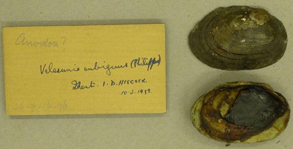
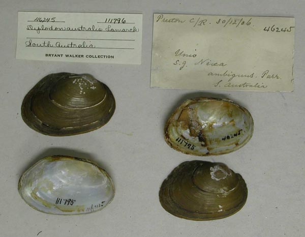
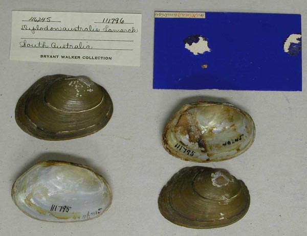
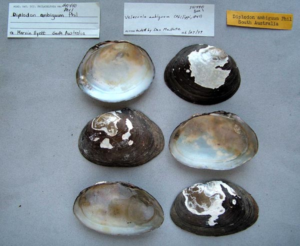
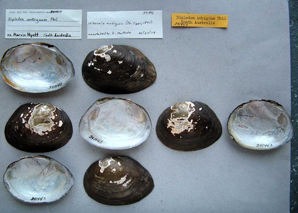
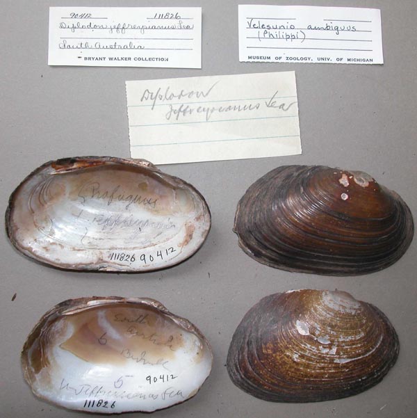
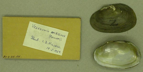
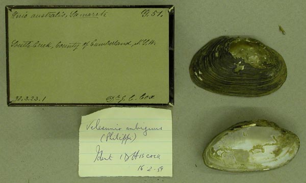
Bivalvia | Unionida | Hyrioidea | Hyriidae | Velesunioninae | Velesunio species Velesunio ambiguus (Philippi, 1847): specimens
13 available nominal species synonyms (19 total synonyms) Recent Taxonomic OpinionsVelesunio ambiguus — Graf & Cummings (2007), Hoeh et al. (2009), Bogan (2010), Whelan et al. (2011), Pfeiffer & Graf (2013), ... Graf & Cummings (2021), Sonowal et al. (2021), Klunzinger et al. (2022), Ponder et al. (2025), Campbell & Lydeard (2026)
Velesunio ambiguous [sic] — Pfeiffer & Graf (2015)
Velesunio cf. ambiguus — Ponder et al. (2025)
Velesunio protovittatus — Ponder et al. (2025) RangeQueensland to Southern Australia, eastern Australia. Map of Georeferenced Specimens
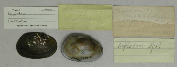
Australia
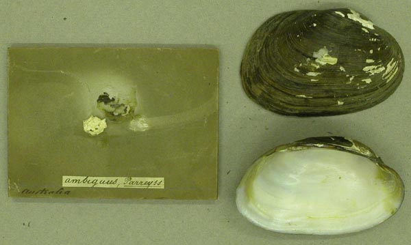
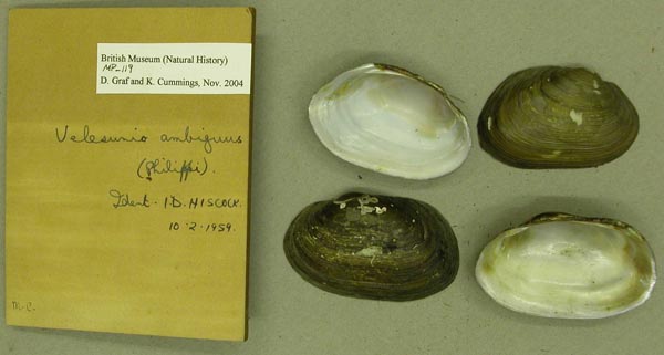
BMNH_54-11-9-3
[Australia]
| 
INHS_11430
[Murrumbidgee River], Gundagai, New South Wales, Australia
| 
BMNH_MP_101
[no locality available - Australia]
| 
MCZ_MP.64
[no locality available - Australia]
| 
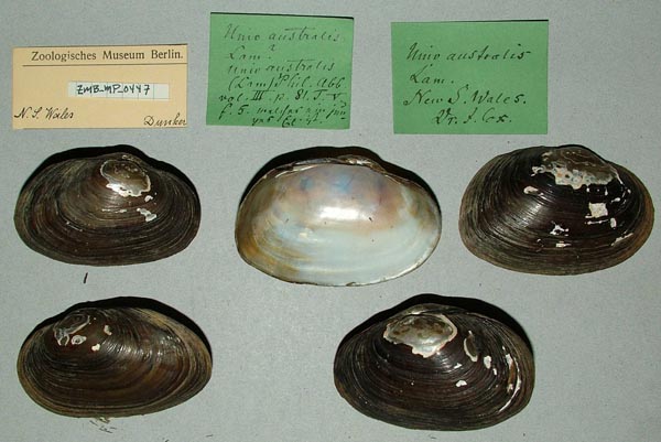
ZMB_MP_0457
[no locality available - Australia]
| 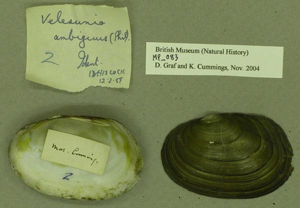
BMNH_MP_083
[no locality available - Australia]
| 
BMNH_MP_411
[no locality available - Australia]
| 
USNM_853907
[no locality available - Australia]
| 
USNM_853907
[no locality available - Australia]
| 
USNM_120822
[no locality available - Australia]
| 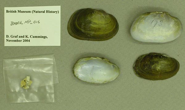
BMNH_MP_016
[no locality available - Australia]
| 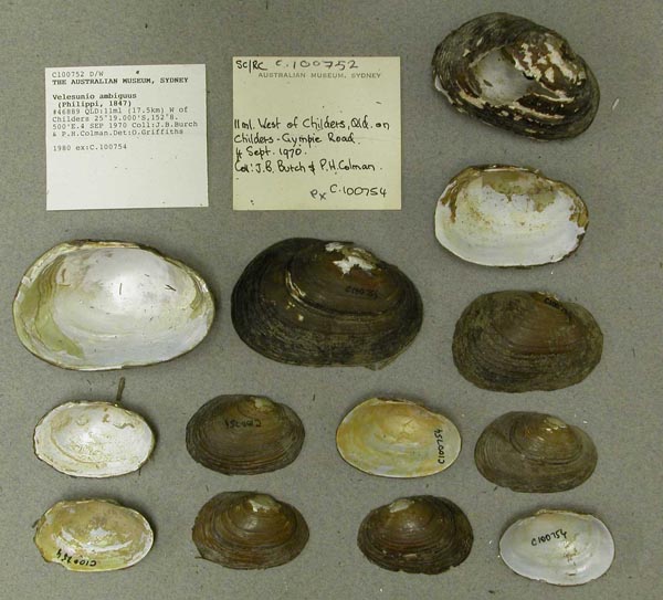
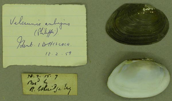
AMS_100752
11 ml (17.5km) W of Childers, Queensland, Australia [-25.317, 152.142 ± 1 km]
| 
AMS_126236
12 mi N of Miriam Vale, 12 Mile Ck, Queensland, Australia [-24.1, 151.467 ± 1 km]
| 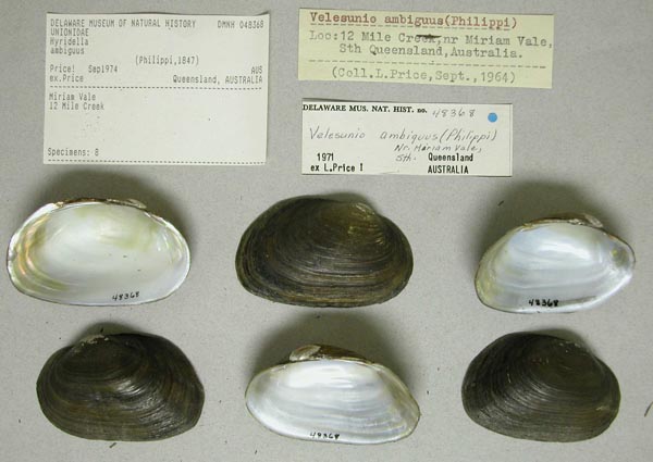
DMNH_48368
12 Mile Creek, near Miriam Vale, South Queensland, Australia
| 
AMS_168583
150 mi E of Tarago, S of Goulburn in Mulwaree Creek (Sandy mud), New South Wales, Australia [-35.07, 149.659 ± 1 km]
| 
AMS_61666
60 km N (=40 mi NW) of Collenebri, W side of Mooni (Moonie R), Cambo Cambo Stn (=Cambo Stn), New South Wales, Australia [-29.08, 148.603 ± 10 km]
| 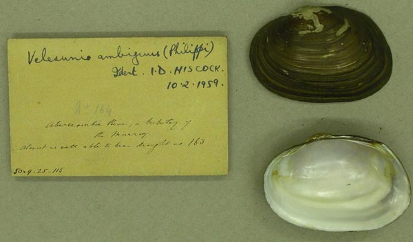
BMNH_50-9-25-115
Abercrombie River, trib. of the Murray River
| 
BMNH_50-9-25-115
Abercrombie River, trib. of the Murray River
| 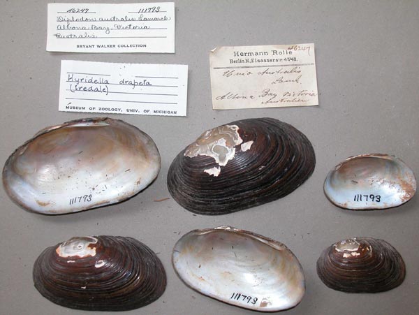
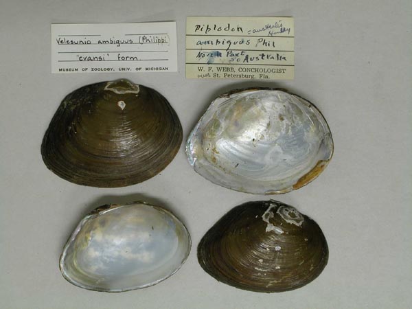
UMMZ_111793
Allbona Bay, Victoria, Australia
| 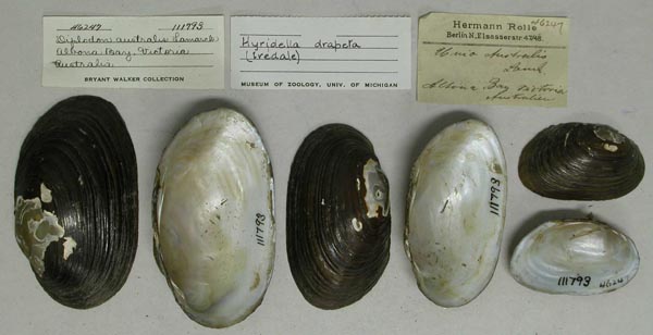
UMMZ_111793
Allbona Bay, Victoria, Australia
| 
AMS_61693
Alligator Creek and Fitzroy River, Queensland
| 
AMS_126238
Alligator Creek, 20 miles N of Rockhampton, Queensland, Australia [-23.142, 150.407 ± 1 km]
| 
MNHN_MP_1470
Altona Bay, Victoria, Australia
| 
AMS_125880
Approx 1.5ml SE of Adavale, Blackwater Ck, Queensland, Australia [-25.9, 144.617 ± 10 km]
| 
AMS_139359
Approx 10 mi from Balranald, Yanga Lake water storage, New South Wales, Australia [-34.733, 143.6 ± 10 km]
| 
AMS_125876
approx 13km from Brisbane, at Brookfield, Gold Ck, Queensland, Australia [-27.5, 152.917 ± 1 km]
| 
BMNH_1952-10-30-72
Australia
| 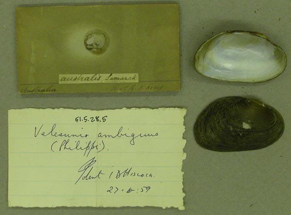
BMNH_51-5-28-5
Australia
| 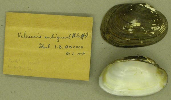
BMNH_40-10-21
Australia
| 
BMNH_40-10-21
Australia
| 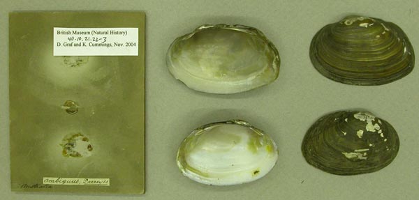
BMNH_40-10-21-22-23
Australia
| 
UMMZ_121207
Australia
| 
UMMZ_121207
Australia
| 
ZMB_MP_0441
Australia
| 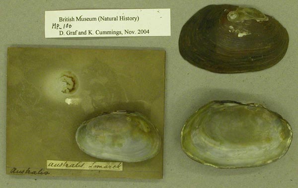
BMNH_MP_100
Australia
| 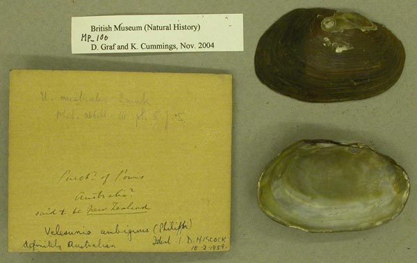
BMNH_MP_100
Australia
| 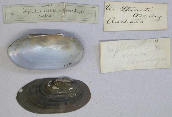
AMNH_61929
Australia
| 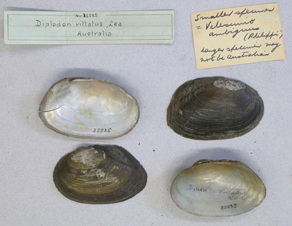
AMNH_35535
Australia
| 
AMNH_30906
Australia
| 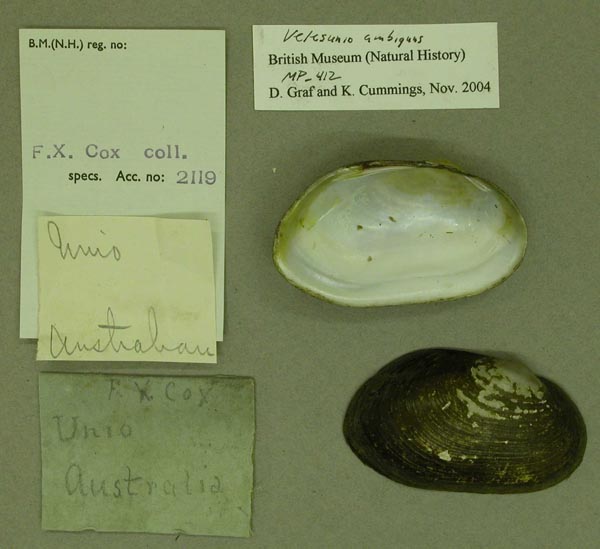
BMNH_MP_412
Australia
| 
BMNH_MP_413
Australia
| 
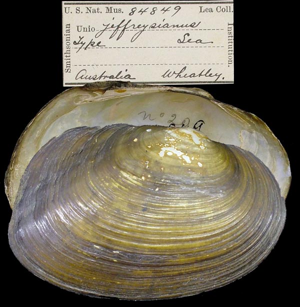
USNM_84849
Australia
| 
USNM_84849
Australia
| 
AMNH_35622
Australia
| 
ANSP_363602
Australia
| 
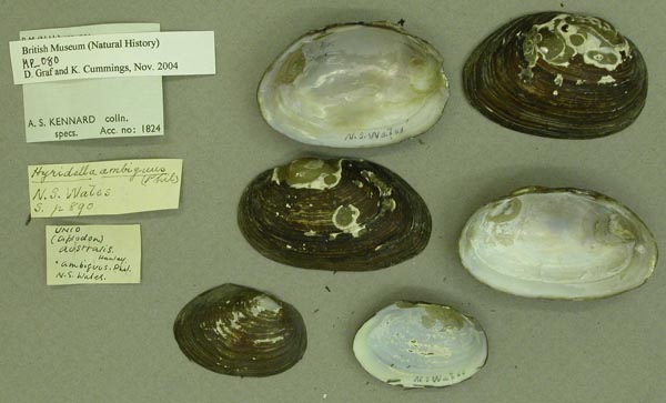
UMMZ_111824
Australia
| 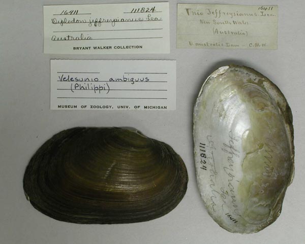
UMMZ_111824
Australia
| 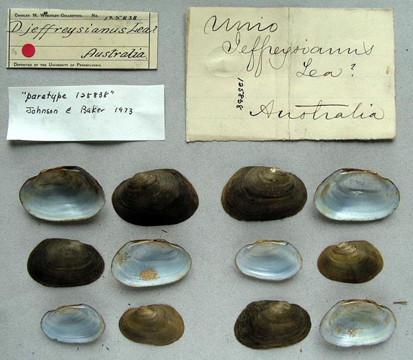
ANSP_125838
Australia
| 
ANSP_125840
Australia
| 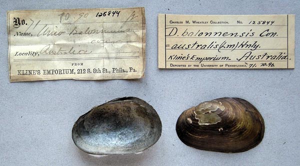
ANSP_125844
Australia
| 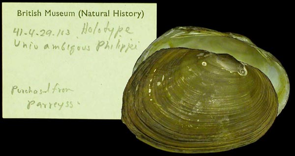
BMNH_41-4-29-103
Australia
| 
BMNH_41-4-29-103
Australia
| 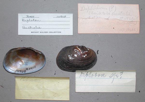
UMMZ_111908
Australia
| 
UMMZ_111908
Australia
| 
BMNH_1958-4-3-1
Australia
| 
BMNH_1958-4-3-1
Australia
| 
BMNH_1958-4-3-1
Australia
| 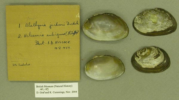
BMNH_MP_189
Australia
| 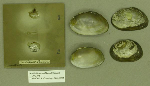
BMNH_MP_189
Australia
| 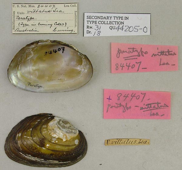
USNM_84407
Australia
| 
MCZ_221847
Australia
| 
MNHN_MP_0038
Australia meridionale
| 
MNHN_MP_0038
Australia meridionale
| 
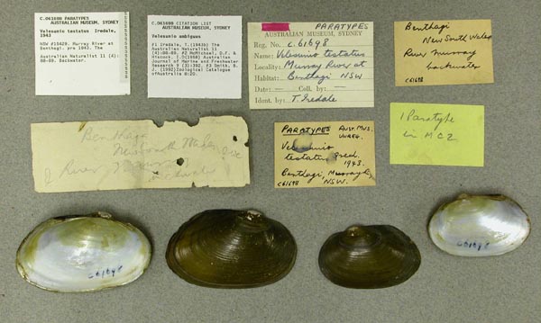
MCZ_190274
backwater of Murray River at Benthagi, New South Wales, Australia
| 
BMNH_88-3-23-11-13
Baffle Creek, Calliope River, Queensland
| 
UMMZ_111297
Bairnsdale, Victoria, Australia
| 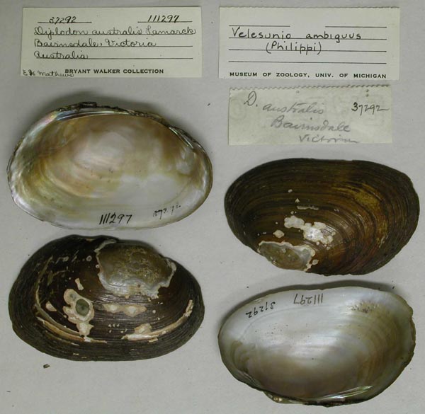
UMMZ_111297
Bairnsdale, Victoria, Australia
| 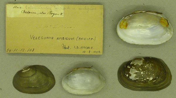
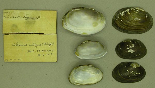
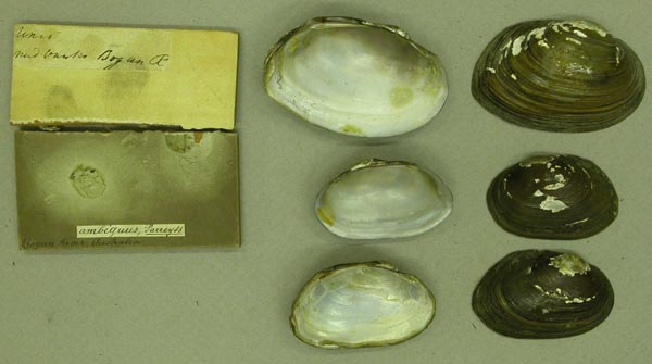
BMNH_59-10-12-103
Balonne and Bogan rivers
| 
BMNH_59-10-12-103
Balonne and Bogan rivers
| 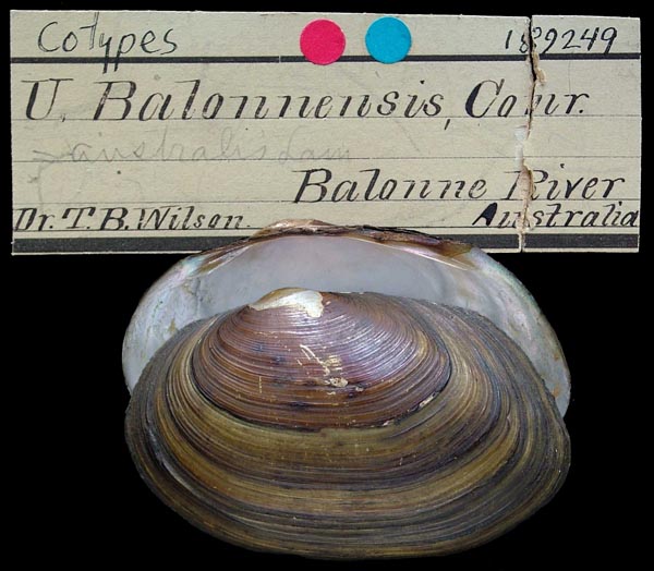
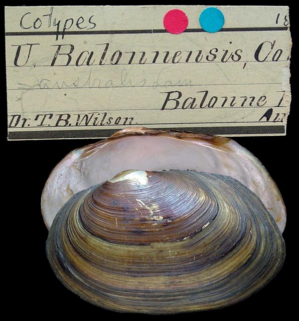
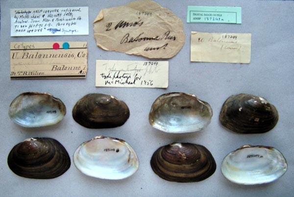
ANSP_189249
Balonne River, Australia
| 
ANSP_189249
Balonne River, Australia
| 
ANSP_189249
Balonne River, Australia
| 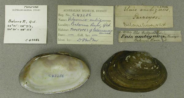
AMS_47286
Balonne River, Queensland
| 
AMS_12032
Balonne River, Queensland
| 
MCZ_72078
Balonne River, Queensland, Australia
| 
AMS_125877
Barambah Ck, trib of Burnett R, Queensland, Australia [-25.617, 151.683 ± 1 km]
| 
AMS_125889
Barwon R, Brewarrina, New South Wales, Australia [-29.95, 146.867 ± 10 km]
| 
AMS_61668
Barwon River near Collarenebri (Billabongs), New South Wales, Australia [-29.55, 148.583 ± 10 km]
| 
AMS_61718
Barwon River, New South Wales; 30°05’S, 147°11’E
| 
AMS_61673
Barwon Rr, 25 km above Brewarrina, New South Wales, Australia [-30.05, 147.083 ± 100 km]
| 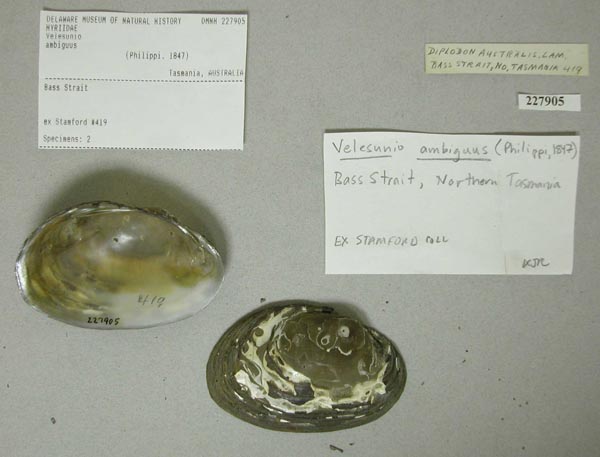
DMNH_227905
Bass Strait, Northern Tasmania, Australia
| 
AMS_125882
Beaudesert, Logan River (Lagoon), Queensland, Australia [-27.983, 153 ± 10 km]
| 
AMS_61684
Benalla, (Broken Creek), Victoria, Australia [-36.55, 145.983 ± 100 km]
| 
AMS_126314
Benalla, Victoria, Australia [-36.55, 145.983 ± 10 km]
| 
CM_61.6876
Billibong Creek (Murray River Dr.), New South Wales, Australia
| 
AMS_125921
Blanchetown, Murray River, Southern Australia, Australia [-34.35, 139.617 ± 1 km]
| 
AMS_126329
Bland Creek near Marsden, New South Wales, Australia [-34.3, 147.8 ± 10 km]
| 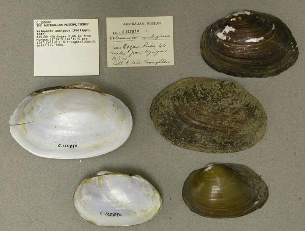
AMS_125890
Bogan R, 65 km from Nyngan, New South Wales, Australia [-31.567, 147.167 ± 100 km]
| 
BMNH_59-10-12-102
Bogan River
| 
BMNH_59-10-12-102
Bogan River
| 
AMS_61897
Bogan River, at Peak Hill, New South Wales, Australia [-32.714, 148.136 ± 10 km]
| 
BMNH_59-10-12-104
Bogan River, NSW
| 
BMNH_59-10-12-104
Bogan River, NSW
| 
MCZ_191955
Bogan River, Peak Hill, New South Wales, Australia
| 
AMS_61669
Bogan River, S of Nyngan, at "Cullubri", New South Wales, Australia [-31.964, 147.246 ± 1 km]
| 
AMS_61900
Box Creek, Cohuna, Victoria, Australia [-35.917, 144.217 ± 10 km]
| 
MCZ_191951
Box Creek, tributary Murray River, Cohuna, Victoria, Australia
| 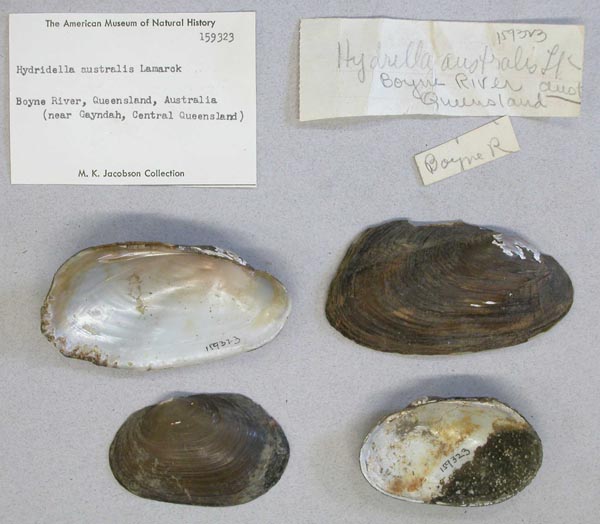
AMNH_159323
Boyne River, near Gayndah, Queensland, Australia
| 
AMS_126234
Brisbane R near Fernvale, Queensland, Australia [-27.45, 152.64 ± 1 km]
| 
AMS_126128
Brisbane, The Blunder, Blunder Ck, Queensland, Australia [-27.617, 152.983 ± 10 km]
| 
MNHN_MP_1509
Bugle Ranges, Sud Australia
| 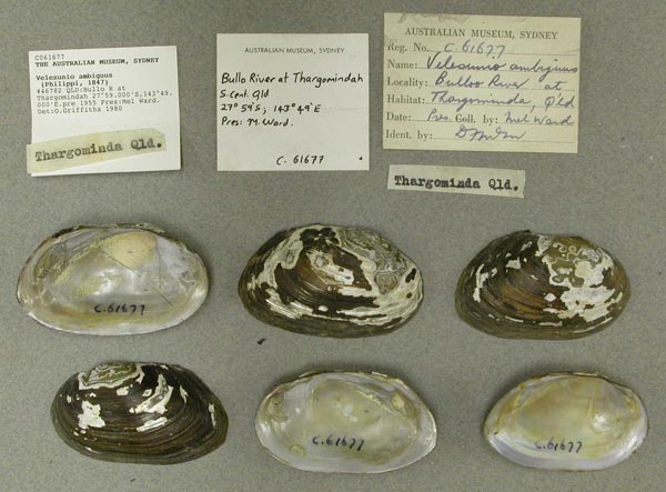
AMS_61677
Bulloo R at Thargomindah, Queensland, Australia [-27.983, 143.817 ± 10 km]
| 
MCZ_191130
Bundaberg, Queensland, Australia
| 
AMS_12031
Burnett River, Bundaberg District, Queensland
| 
AMS_125887
Burraburra Creek, Tributary of Abercrombie River, New South Wales, Australia [-34.233, 149.667 ± 100 km]
| 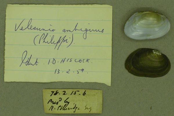
BMNH_78-2-15-6
Cacupaspe River, Spring Plains, Victoria
| 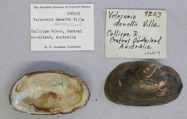
AMNH_146529
Calliope River, Central Queensland, Australia
| 
USNM_568971
Canal Creek, Darling Downs, Australia
| 
AMS_420518
Carpet Springs Stn, S of Bulloo Developmental Rd, waterholes in Yowah Ck (On wood & crawling along edges of waterhole in mud.), Queensland, Australia [-28.139, 144.864 ± 100 m]
| 
AMS_100742
Castlereagh River at Binnaway Rd, 14km S of Coonabarabran (Pool under bridge), New South Wales, Australia [-31.317, 149.333 ± 1 km]
| 
AMS_61671
Castlereagh River at Gilgandra, New South Wales, Australia [-31.717, 148.65 ± 10 km]
| 
AMS_125892
Cawndilla Crk, between Menindee Lake and Cawndilla Lake, NW from Kinchega Stn homestead, New South Wales, Australia [-32.42, 142.274 ± 10 km]
| 
AMS_61887
Clarence River upper reaches at Woodenbong, New South Wales, Australia [-28.383, 152.617 ± 10 km]
| 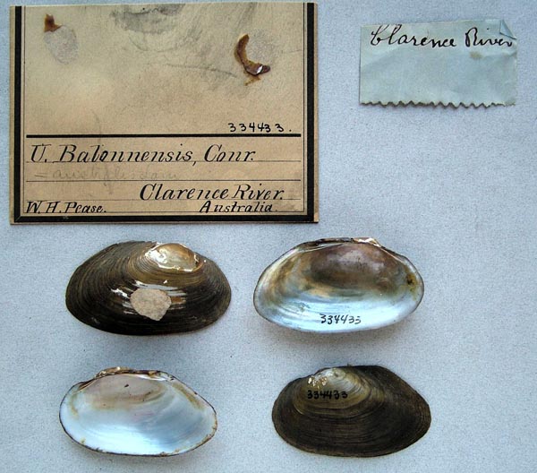
ANSP_334433
Clarence River, Australia
| 
UMMZ_22870
Clarence River, Australia
| 
UMMZ_22870
Clarence River, Australia
| 
MCZ_191952
Clarence River, Woodenbong, New South Wales, Australia
| 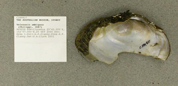
AMS_389837
Clarenza, New South Wales, Australia [-29.707, 153.018 ± 10 km]
| 
AMS_61709
Clearfield Hill Railway Tank, between Grafton and Casino, New South Wales, Australia [-29.15, 152.933 ± 1 km]
| 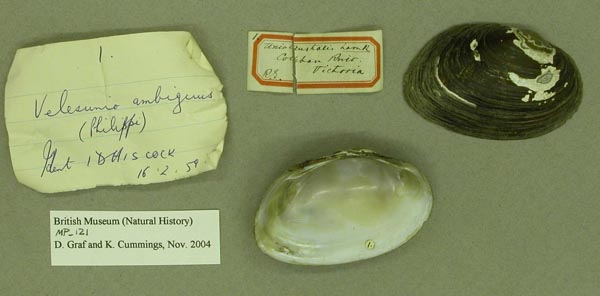
BMNH_MP_121
Cobbin River, Victoria
| 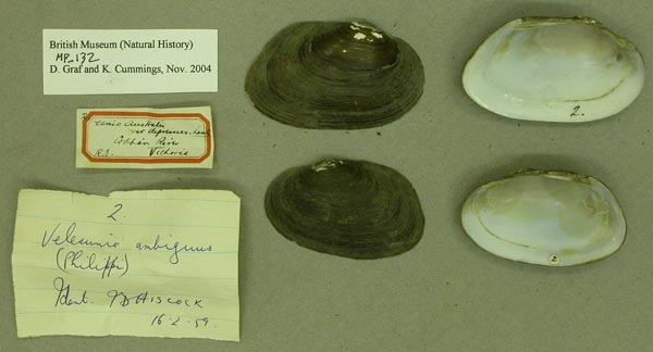
BMNH_MP_132
Cobbin River, Victoria
| 
BMNH_78-2-15-7
Colibau River, Crawford Crossing, Victoria
| 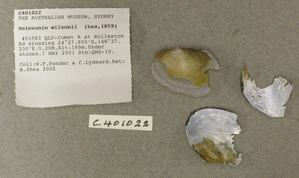
AMS_401022
Comet R at Rolleston Rd crossing (Under stones), Queensland, Australia [-24.465, 148.62 ± 100 m]
| 
USNM_623343
Condamine R. Warwick, S. Qld., Australia
| 
USNM_623343
Condamine R. Warwick, S. Qld., Australia
| 
USNM_568974
Condamine River, Australia
| 
USNM_623341
Condamine River, Dalby, Queensland, Australia
| 
USNM_623341
Condamine River, Dalby, Queensland, Australia
| 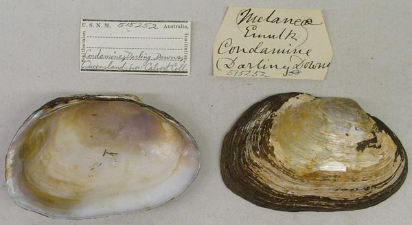
USNM_515252
Condamine River, Darling Downs, Queensland, Australia
| 
MCZ_186726
Condamine River, near Dalby, Darling Downs, Queensland, Australia
| 
AMS_125849
Condamine River, Queensland, Australia [-27.117, 149.8 ± 100 km]
| 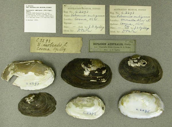
AMS_2293
Cooma, Numeralla (Umerella) River, New South Wales, Australia [-36.143, 149.979 ± 100 km]
| 
AMS_125809
Coraki Aboriginal Station, New South Wales, Australia [-29, 153.267 ± 1 km]
| 
AMS_133341
Cowra, Wyangala Dam, NE bank, 1km NE from spillway, New South Wales, Australia [-33.971, 148.95 ± 10 km]
| 
AMS_61700
Creek near Port Curtis, near Gladstone, Queensland, Australia [-23.917, 151.383 ± 10 km]
| 
AMS_61667
creek, near Brisbane, Queensland
| 
AMS_125811
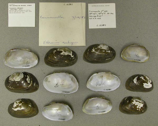
Cunnamulla, Queensland, Australia [-28.067, 145.683 ± 10 km]
| 
AMS_125811
Cunnamulla, Queensland, Australia [-28.067, 145.683 ± 10 km]
| 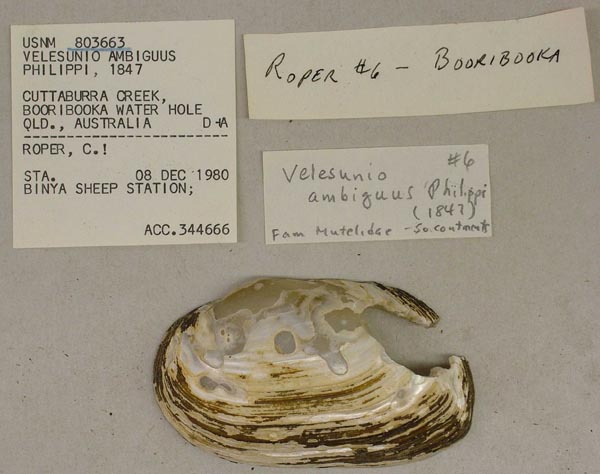
USNM_803663
Cuttaburra Creek, Boorobooka Water Hole, Queensland, Australia
| 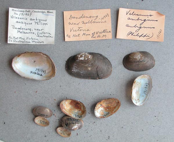
MCZ_191969
Dandendong, near Melbourne, Australia
| 
AMS_57943
Dandenong, Victoria, Australia [-37.983, 145.217 ± 10 km]
| 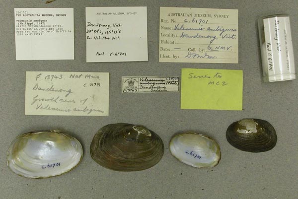
AMS_61701
Dandenong, Victoria, Australia [-37.983, 145.217 ± 10 km]
| 
BMNH_46-10-7-6-9
Darling Downs, NSW
| 
BMNH_46-10-7-6-9
Darling Downs, NSW
| 
AMS_383627
Darling R, "Brian Murrays Pdk", Curranyalpa Block, New South Wales, Australia [-30.882, 144.696 ± 1 km]
| 
BMNH_88-11-28-4
Darling River
| 
BMNH_88-11-28-4
Darling River
| 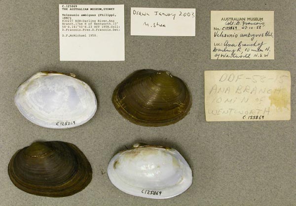
AMS_125869
Darling River, Ana Branch,17km N of Wentworth, New South Wales, Australia [-33.967, 141.833 ± 10 km]
| 
AMS_61676
Darling River, Bourke, New South Wales, Australia [-30.1, 145.933 ± 10 km]
| 
AMS_47296
Darling River, Bourke, New South Wales, Australia [-30.1, 145.933 ± 10 km]
| 
CM_61.7679
Darling River, New South Wales, Australia
| 
MCZ_243496
Dawson River, Moura, 140 mi SW Rockhampton, Queensland, Australia
| 
AMS_125814
Dubbo, Macquarie R, New South Wales, Australia [-32.25, 148.617 ± 10 km]
| 
AMS_61679
Dumaresq River at Boggabilla, New South Wales, Australia [-28.617, 150.367 ± 1 km]
| 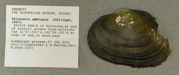
AMS_404577
E of Rylstone, Rylstone Dam, Cudgegong R, at end of council access road (At water's edge, in sand, near submerged grasses), New South Wales, Australia [-32.792, 149.985 ± 1 km]
| 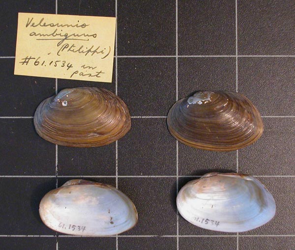
CM_61.1534
East coast of Australia
| 
CM_61.1534
East coast of Australia
| 
MCZ_191959
Eastern Creek, Quakers Hill, near Sydney, New South Wales, Australia
| 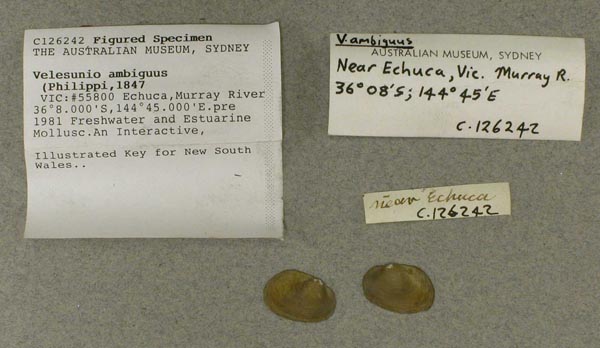
AMS_126242
Echuca, Murray River, Victoria, Australia [-36.133, 144.75 ± 10 km]
| 
AMS_83835
Esk, Brisbane River, Queensland, Australia [-27.233, 152.417 ± 10 km]
| 
AMS_125893
Euabalong, Booberoi Crk, W NSW, New South Wales, Australia [-33.072, 146.409 ± 100 km]
| 
AMS_125895
Fish River at Oberon, New South Wales, Australia [-33.717, 149.867 ± 10 km]
| 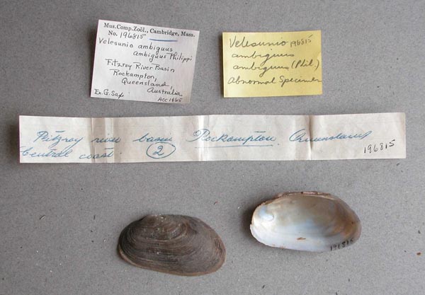
MCZ_196815
Fitzroy River Basin, Rockhampton, Queensland, Australia
| 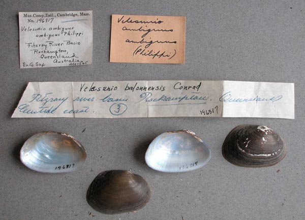
MCZ_196817
Fitzroy River Basin, Rockhampton, Queensland, Australia
| 
AMS_376217
Frankston Creek (FrankstonI?), Port Phillip, Victoria, Australia [-38.176, 145.127 ± 1 km]
| 
AMS_61732
Frogmore Lagoon, Rockhampton, Queensland, Australia [-23.446, 150.539 ± 1 km]
| 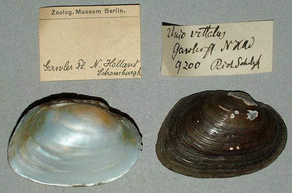
ZMB_9200A
Gawler fl., New South Wales, New Holland
| 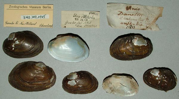
ZMB_MP_0465
Gawler Fluss, New Holland
| 
MCZ_175536
Gawler River, South Australia
| 
BMNH_MP_079
Geelong, Queensland
| 
AMS_61687
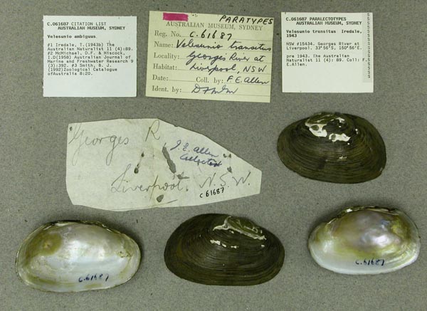
Georges River at Liverpool, New South Wales, Australia [-33.929, 150.867 ± 1 km]
| 
AMS_30329
Georges River, above Liverpool Railway Bridge, New South Wales, Australia [-33.595, 150.927 ± 1 km]
| 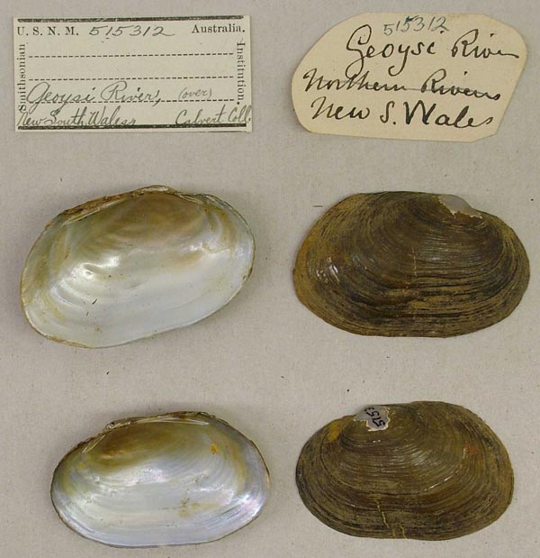
USNM_515312
Geoysi River, New South Wales, Australia
| 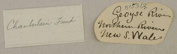
USNM_515312
Geoysi River, New South Wales, Australia
| 
AMS_42562
Gin Gin Creek, near Bundaberg, Queensland, Australia [-24.933, 152.017 ± 10 km]
| 
AMS_61696
Ginninderra Creek near Canberra, New South Wales, Australia [-35.217, 149.05 ± 10 km]
| 
CM_61.5617
Gippsland, Victoria, Australia
| 
AMS_125919
Glenelg River at Dergholm near Casterton, Victoria, Australia [-37.367, 141.217 ± 1 km]
| 
AMS_61882
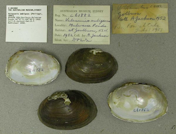
Goulburn, Mulwaree Ponds, New South Wales, Australia [-34.95, 149.667 ± 100 km]
| 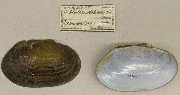
USNM_363025
Gracemere Lagoon, near Rockhampton, Queensland
| 
USNM_363025
Gracemere Lagoon, near Rockhampton, Queensland
| 
DMNH_172994
Gracemere Lagoon, near Rockhampton, Queensland, Australia
| 
AMS_125952B
Gregory R, Proserpine District, Australia
| 
AMS_126373
Gundagai, Murrumbidgee River, New South Wales, Australia [-35.067, 148.117 ± 10 km]
| 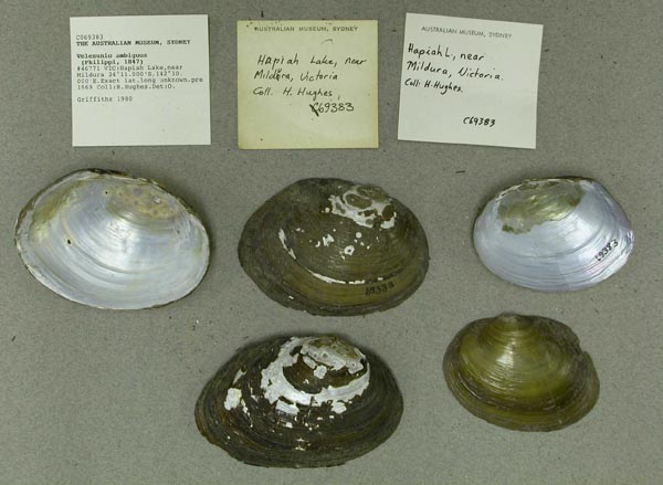
AMS_69383
Hapiah Lake, near Mildura, Victoria, Australia [-34.183, 142.167 ± 100 km]
| 
ANSP_71737
Hope Valley Reservoir, nr. Adelaide, Aust.
| 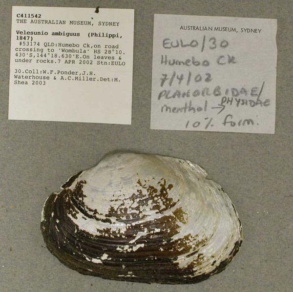
AMS_411542
Humebo Ck, on road crossing to "Wombula" HS (On leaves & under rocks), Queensland, Australia [-28.174, 144.31 ± 100 m]
| 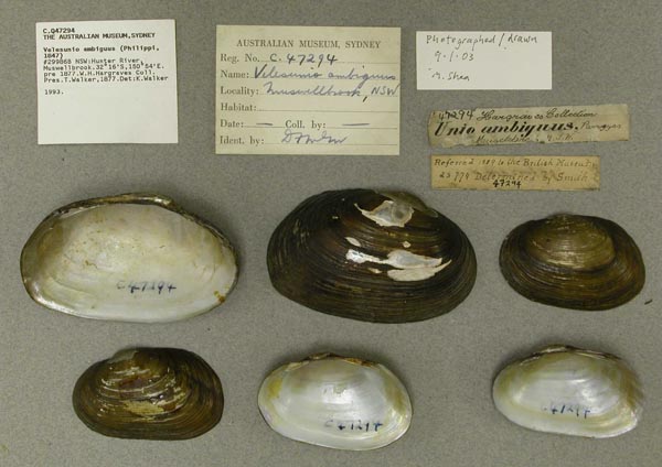
AMS_47294
Hunter River, Muswellbrook, New South Wales, Australia [-32.267, 150.9 ± 10 km]
| 
ANSP_334435
Hunter River, N.S. Wales
| 
AMS_125886
Hunter River, New South Wales
| 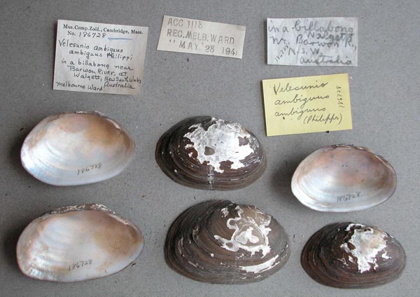
MCZ_186728
in a billabong, near Barioon River, at Walgett, New South Wales, Australia
| 
MCZ_191953
Irrigation channel, creek near Lake Talbot Narrandera (Murrumbidgee River), New South Wales, Australia
| 
BMNH_85-6-12-80-82
Isaac and Burnett rivers, Queensland
| 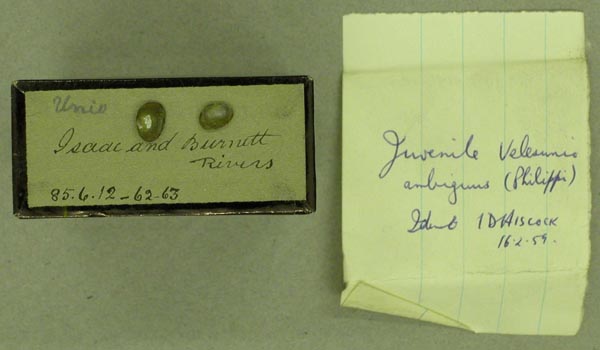
BMNH_85-6-12-62-63`
Isaac and Burnett rivers, Queensland
| 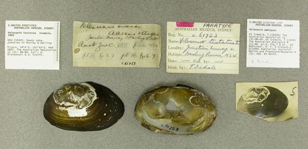
AMS_61723
Junction of Murray & Darling Rivers, reedy lake, New South Wales, Australia [-34.058, 141.867 ± 10 km]
| 
AMS_57945
Junction of Murray & Darling Rivers, reedy lake, New South Wales, Australia [-34.058, 141.867 ± 10 km]
| 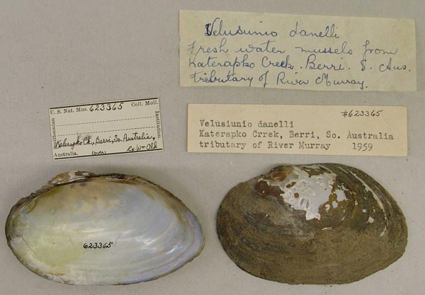
USNM_623365
Katerapko Creek, Berri, So. Australia; trib Murray River
| 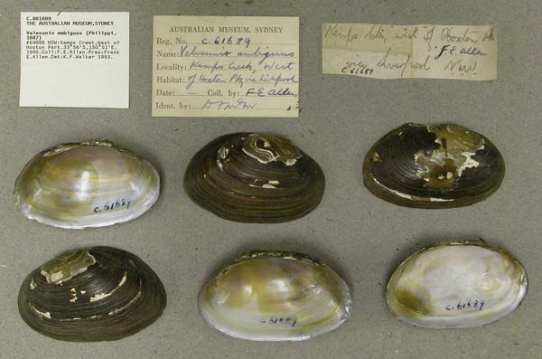
AMS_61689
Kemps Creek, West of Hoxton Park, New South Wales, Australia [-33.933, 150.667 ± 10 km]
| 
AMS_154120
Kinchega National Park, Lake Cawndilla, SW of Menindee, New South Wales, Australia [-32.5, 142.233 ± 10 km]
| 
AMS_125868
Kings Creek, Darling River System, 1 mi N Clifton, New South Wales; 30°48’S, 144°08’E
| 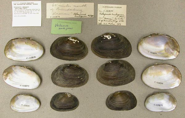
AMS_125879
Korenan, 60 miles N. of Bundaberg, Queensland, Australia [-24.467, 151.667 ± 1 km]
| 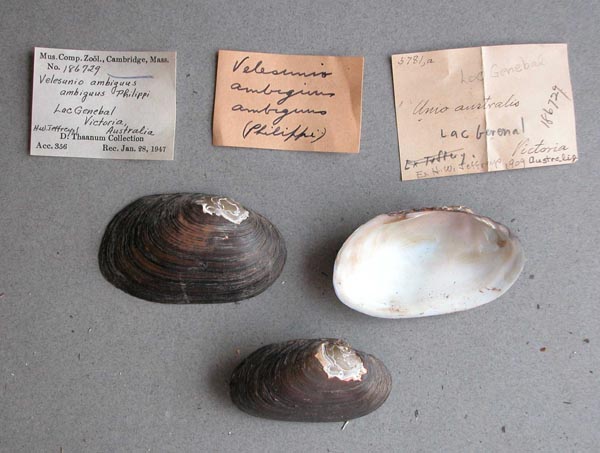
MCZ_186729
Lac Genebal, Victoria, Australia
| 
MCZ_103935
Lachlan River, Hillston, New South Wales, Australia
| 
ZMB_9083A
laggon bei Murray River, So Australia
| 
AMS_49127
Lagoon at Baan Baa near Namoi River, New South Wales, Australia [-30.6, 149.95 ± 10 km]
| 
BMNH_89-10-25-30-35
lagoon near Casio, Richmond River, NSW
| 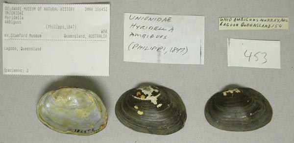
DMNH_186453
lagoon, Queensland, Australia
| 
BMNH_40-10-26-42
Lagoons of Lower Murray River, South Australia.
| 
BMNH_40-10-26-42
Lagoons of Lower Murray River, South Australia.
| 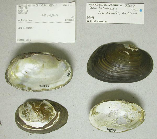
DMNH_78613
Lake Alexander, Australia
| 
AMS_47285
Lake Alexander, Victoria, Australia [-37.783, 142.833 ± 10 km]
| 
UMMZ_111840
Lake Alexandria, Murray Mouth, South Australia
| 
UMMZ_111840
Lake Alexandria, Murray Mouth, South Australia
| 
UMMZ_111823
Lake Alexandria, South Australia
| 
UMMZ_111823
Lake Alexandria, South Australia
| 
UMMZ_111823
Lake Alexandria, South Australia
| 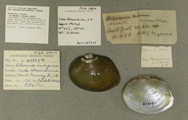
AMS_47309-F
Lake Alexandrina, Lower Murray, Southern Australia, Australia [-35.467, 138.983 ± 10 km]
| 
AMS_47309
Lake Alexandrina, Lower Murray, Southern Australia, Australia [-35.467, 138.983 ± 10 km]
| 
ANSP_71735
Lake Alexandrina, mouth of Murray R., Aust.
| 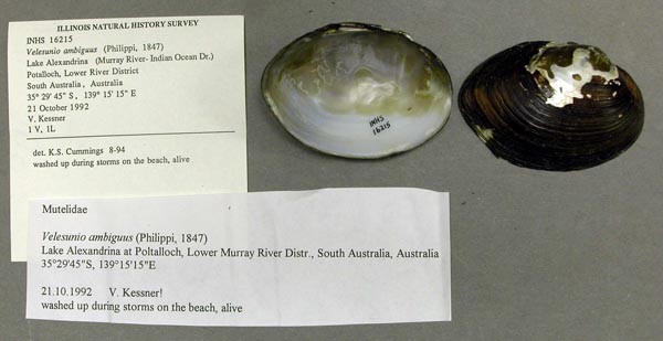
INHS_16215
Lake Alexandrina, Potalloch, Lower River District, South Australia, Australia
| 
AMS_125920
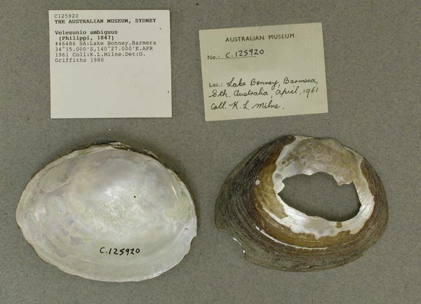
Lake Bonney, Barmera, Southern Australia, Australia [-34.25, 140.45 ± 1 km]
| 
AMS_88007
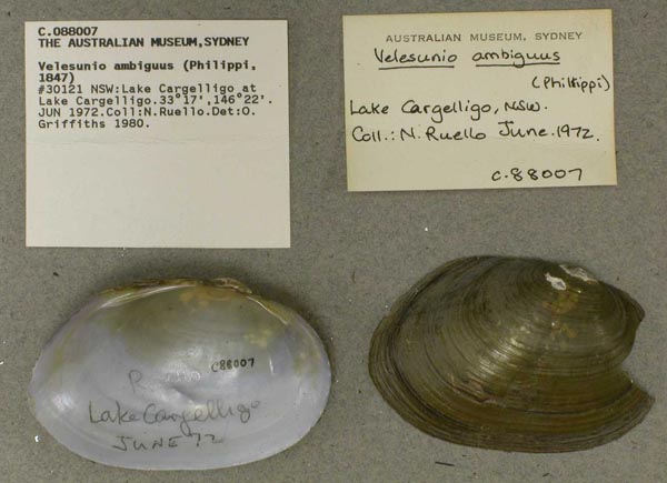
Lake Cargelligo at Lake Cargelligo, New South Wales, Australia [-33.283, 146.367 ± 10 km]
| 
AMS_12264
Lake Cargelligo, Lake Crk, New South Wales, Australia [-33.25, 146.417 ± 10 km]
| 
AMS_125884
Lake Dartmouth, near Ambathalla, Queensland, Australia [-26.067, 145.3 ± 10 km]
| 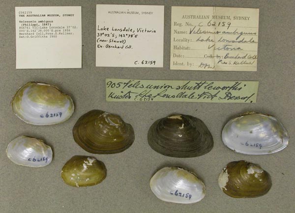
AMS_62159
Lake Lonsdale, Victoria, Australia [-37.033, 142.633 ± 10 km]
| 
AMS_125775
Lake Manchester, Queensland, Australia [-27.483, 152.783 ± 10 km]
| 
AMS_153271
Lake Menindee, SE shore near caravan park, New South Wales, Australia [-32.355, 142.408 ± 1 km]
| 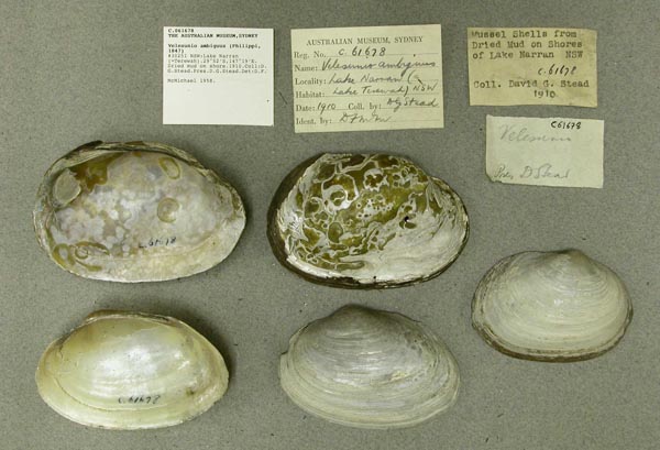
AMS_61678
Lake Narran (=Terewah) (Dried mud on shore), New South Wales, Australia [-29.867, 147.317 ± 10 km]
| 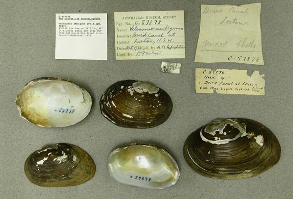
AMS_57878
Leeton (Dried canal), New South Wales, Australia [-34.55, 146.4 ± 10 km]
| 
AMS_47297
Lilydale, Victoria, Australia [-37.767, 145.35 ± 10 km]
| 
USNM_623354
Logan River, 4 miles N of Beaudesert, Queensland, Australia
| 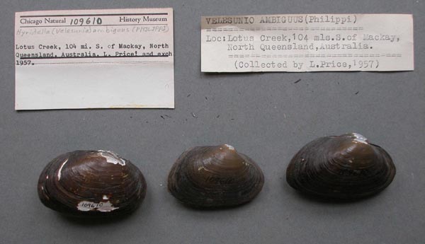
FMNH_109610
Lotus Creek, 104 mi S Mackay, North Queensland, Australia
| 
MCZ_231989
lower Murray River, South Australia
| 
BMNH_MP_180
Macintyre River, NSW
| 
AMS_118188
Mackenzie River, Queensland, Australia [-23.583, 149.733 ± 100 km]
| 
AMS_61665
Macquarie River at Warren, New South Wales, Australia [-31.7, 147.833 ± 10 km]
| 
AMS_125813
Macquarie River, Dundallamel, New South Wales
| 
AMS_125878
Maryborough (In ponds), Queensland, Australia [-25.517, 152.7 ± 10 km]
| 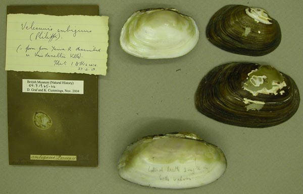
BMNH_54-7-19-65-66
Melbourne
| 
BMNH_1952-10-28-1
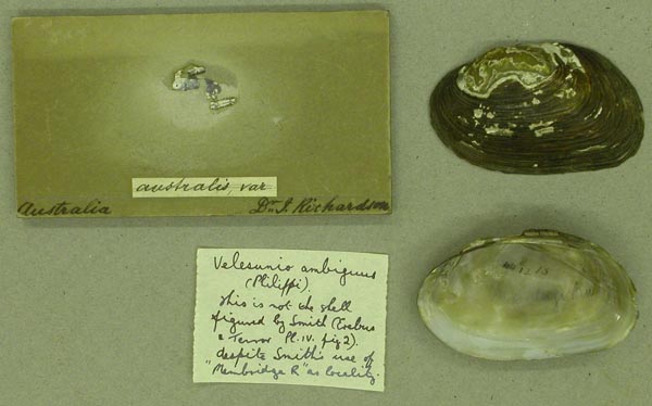
Membridge River
| 
BMNH_1952-10-28-1
Membridge River
| 
AMS_62031
Menindee (=Menindie), New South Wales, Australia [-32.394, 142.414 ± 10 km]
| 
AMS_140526
Menindee Lake, Kinchega National Park, Menindee, New South Wales, Australia [-32.392, 142.417 ± 10 km]
| 
AMS_47291
Miriam Vale, Baffle Ck, Queensland, Australia [-24.333, 151.567 ± 10 km]
| 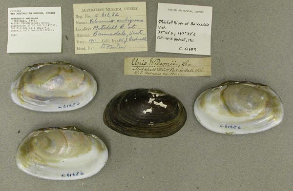
AMS_61682
Mitchell River, Bairnsdale, Victoria, Australia [-37.833, 147.617 ± 10 km]
| 
AMS_61692
Mitchell River, Bairnsdale, Victoria, Australia [-37.833, 147.617 ± 10 km]
| 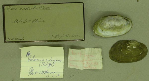
BMNH_99-10-25-36
Mitchell River, Victoria
| 
MCZ_191958
Mondellin, 10 mi S of junction of Murray and Darling rivers, Victoria, Australia
| 
AMS_33007
Mooni (Moonie) River N of Collarenebri, New South Wales, Australia [-29.05, 148.667 ± 10 km]
| 
AMS_47282
Mooni (Moonie) River, near Collarenebri, New South Wales, Australia [-29.233, 148.65 ± 100 km]
| 
MCZ_191956
Moonie River, near Mogil Mogil, New South Wales, Australia
| 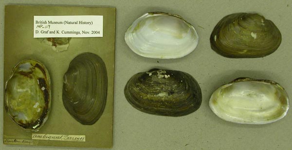
BMNH_MP_119
Moreton Bay
| 
BMNH_MP_119
Moreton Bay
| 
AMS_138824
Morgan, Murray River, Southern Australia, Australia [-34.033, 139.667 ± 1 km]
| 
AMS_126277
Murray & Yeppen Lagoons, Rockhampton, Queensland
| 
FMNH_190536
Murray Bridge, South Australia
| 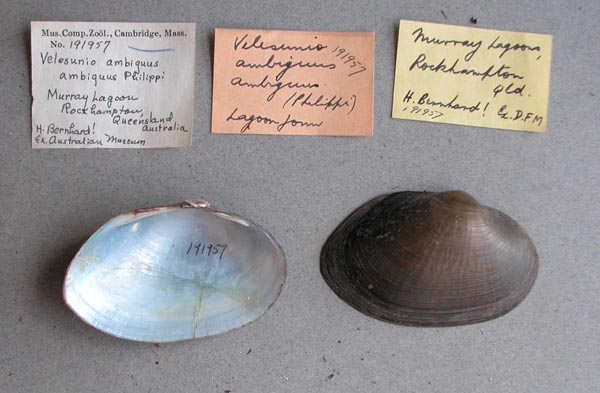
MCZ_191957
Murray Lagoon, Rockhampton, Queensland, Australia
| 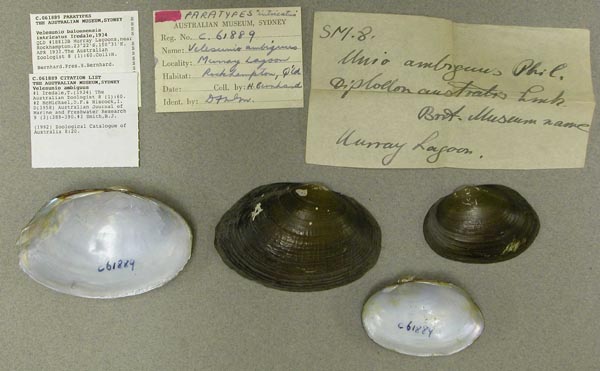
AMS_61889
Murray Lagoons, near Rockhampton, Queensland, Australia [-23.367, 150.517 ± 1 km]
| 
USNM_623342
Murray R., Mannum, South Australia, Australia
| 
USNM_623342
Murray R., Mannum, South Australia, Australia
| 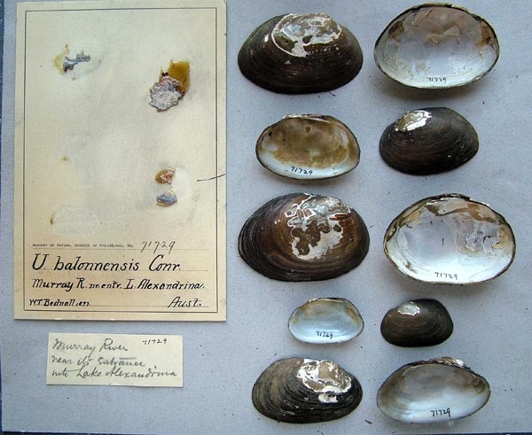
ANSP_71729
Murray R., nr. entr. L. Alexandrina, Aust.
| 
ZMB_9083
Murray River
| 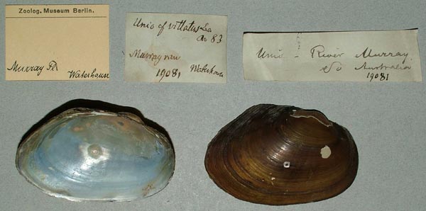
ZMB_19081
Murray River
| 
AMS_61698
Murray River at Benthagi (Backwater), New South Wales, Australia
| 
AMS_125867
Murray River at Benthagi (Backwater), New South Wales, Australia
| 
AMS_61699
Murray River at Benthagi (Backwater), New South Wales, Australia
| 
AMS_125922
Murray River at Mannum, Southern Australia, Australia [-34.917, 139.3 ± 1 km]
| 
AMS_62012
Murray River at Mannum, Southern Australia, Australia [-34.917, 139.3 ± 1 km]
| 
AMS_61706
Murray River at Mannum, Southern Australia, Australia [-34.917, 139.3 ± 1 km]
| 
AMS_375559
Murray River at Morgan, Southern Australia, Australia [-34.033, 139.65 ± 1 km]
| 
AMNH_93635
Murray River, Australia
| 
ANSP_125830
Murray River, Australia
| 
ANSP_125830
Murray River, Australia
| 
ANSP_125843
Murray River, Australia
| 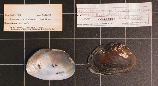
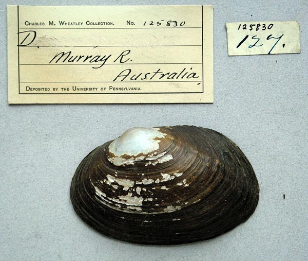
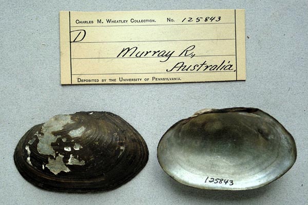
CM_61.13317
Murray River, Australia
| 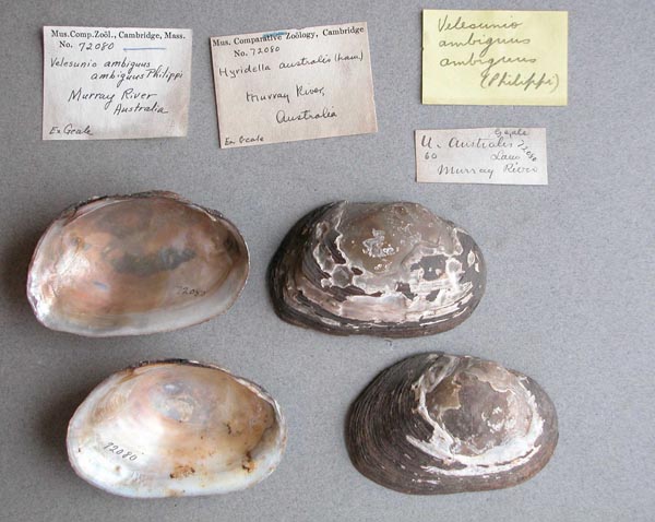
MCZ_72080
Murray River, Australia
| 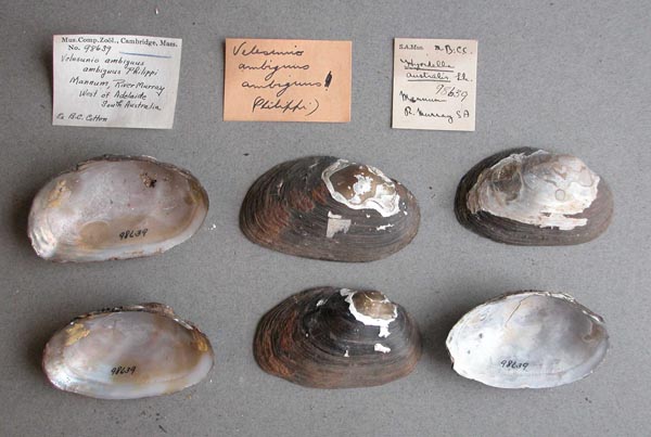
MCZ_98639
Murray River, Mannum, West of Adelaide, South Australia
| 
DMNH_150028
Murray River, Mildura, Victoria, Australia
| 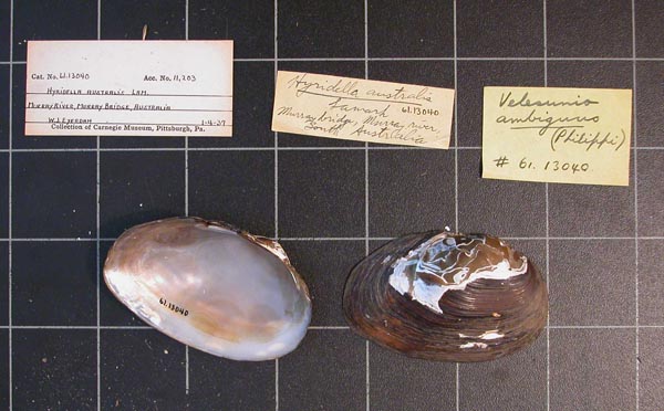
CM_61.13040
Murray River, Murray Bridge, South Australia
| 
MCZ_110402
Murray River, Murray Bridge, South Australia
| 
MCZ_110401
Murray River, Murray Bridge, South Australia
| 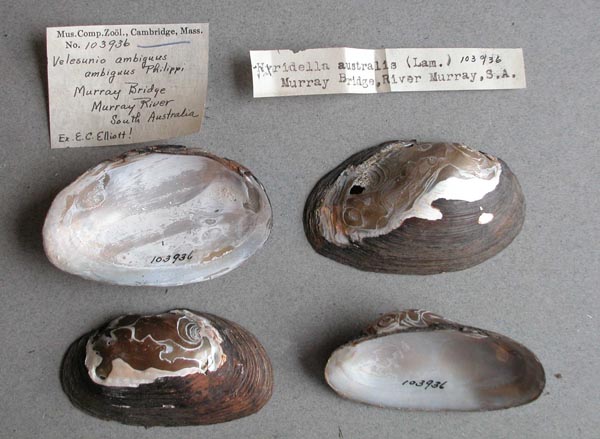
MCZ_103936
Murray River, Murray Bridge, South Australia
| 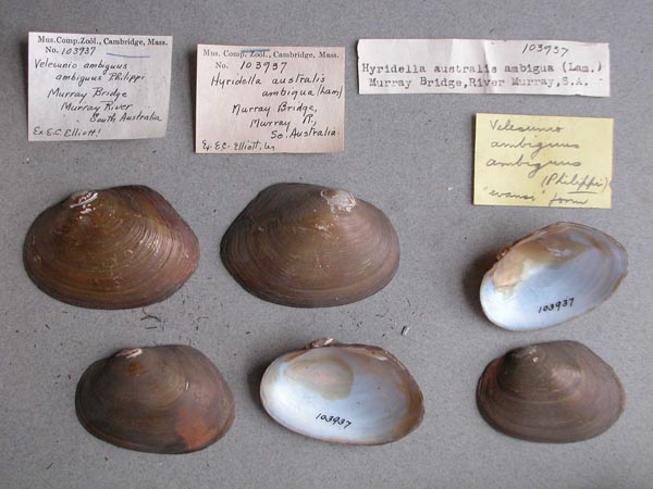
MCZ_103937
Murray River, Murray Bridge, South Australia
| 
SBMHN_367450
Murray River, Murray bridge, South Australia
| 
AMS_61903
Murray River, Murray Bridge, Southern Australia, Australia [-35.117, 139.267 ± 1 km]
| 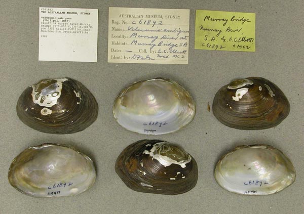
AMS_61892
Murray River, Murray Bridge, Southern Australia, Australia [-35.117, 139.267 ± 1 km]
| 
SBMHN_27130
Murray River, North Lake, South Australia
| 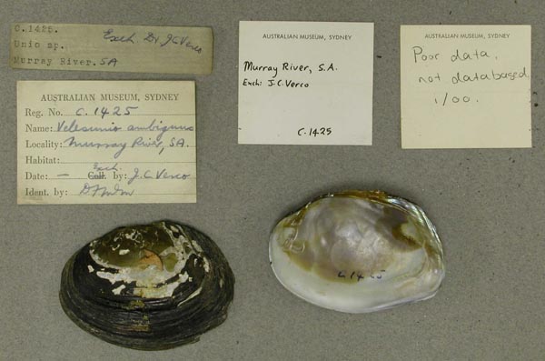
AMS_1425
Murray River, SA
| 
AMS_1426
Murray River, SA
| 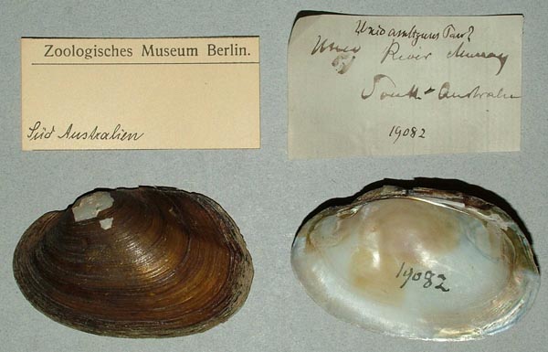
ZMB_19082
Murray River, South Australia
| 
AMNH_164767
Murray River, South Australia
| 
AMNH_146524
Murray River, South Australia
| 
AMNH_159309
Murray River, South Australia
| 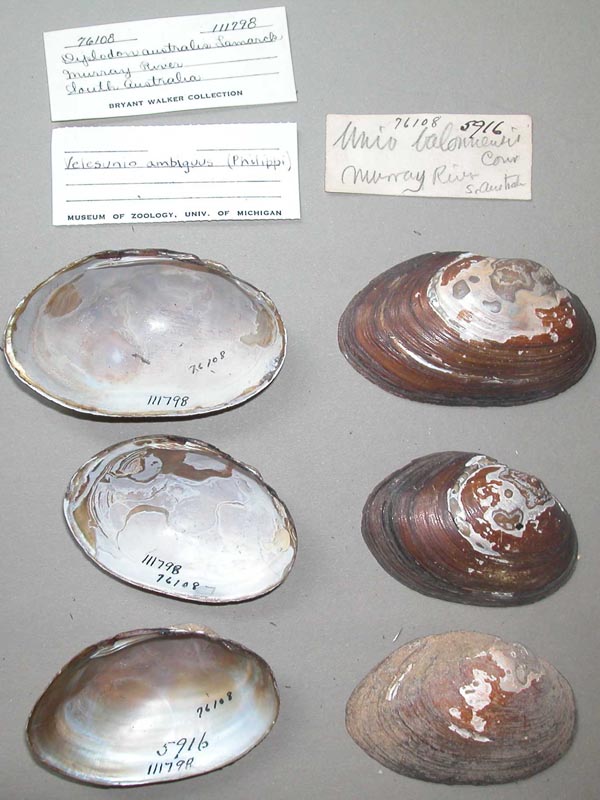
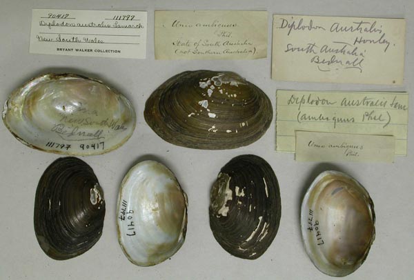
UMMZ_111798
Murray River, South Australia
| 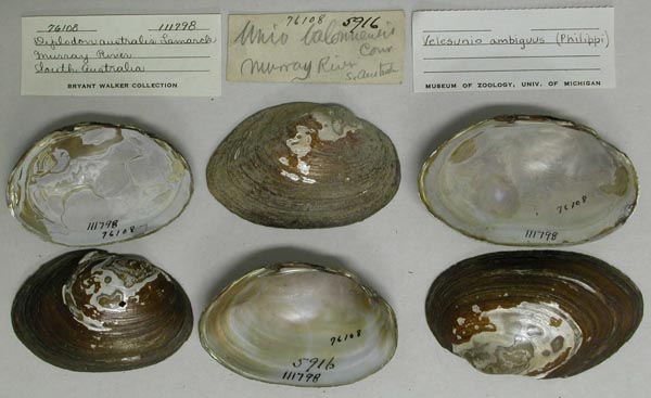
UMMZ_111798
Murray River, South Australia
| 
MCZ_50893
Murray River, South Australia
| 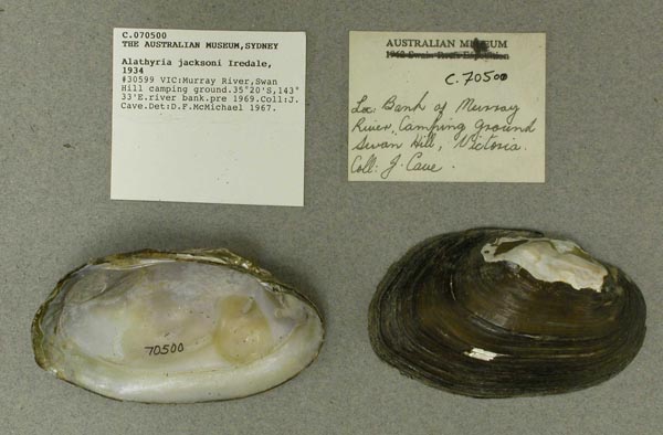
AMS_70500
Murray River, Swan Hill camping ground (river bank), Victoria, Australia [-35.333, 143.55 ± 10 km]
| 
MCZ_67977
Murray River, Tailem Bend, Russel, South Australia
| 
MCZ_104244
Murray River, Tailem Bend, Russel, South Australia
| 
MCZ_66333
Murray River, Tailem Bend, South Australia
| 
MCZ_186727
Murray River, Tartanga Lagoon, near Nildottie, South Australia
| 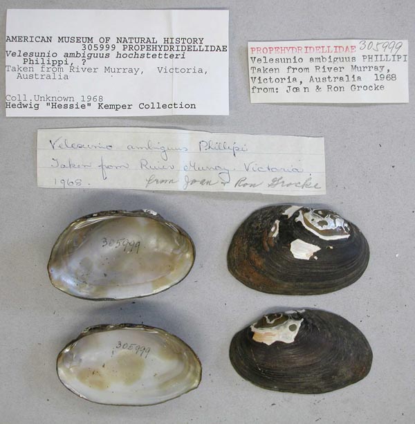
AMNH_305999
Murray River, Victoria, Australia
| 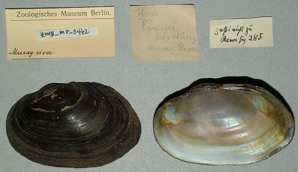
ZMB_MP_0462
Murrray River, Australia
| 
AMS_61902
Murrumbidgee R, at Griffith, irrigation area, New South Wales, Australia [-34.283, 146.033 ± 100 km]
| 
AMS_61680
Murrumbidgee River at Leeton, New South Wales, Australia [-34.617, 146.383 ± 10 km]
| 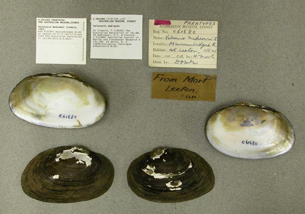
AMS_61680
Murrumbidgee River at Leeton, New South Wales, Australia [-34.617, 146.383 ± 10 km]
| 
AMS_170637
Murrumbidgee River at Leeton, New South Wales, Australia [-34.617, 146.383 ± 10 km]
| 
AMS_61721
Murrumbidgee River at Leeton, New South Wales, Australia [-34.617, 146.383 ± 10 km]
| 
AMS_61727
Murrumbidgee River at Wagga Wagga, New South Wales, Australia [-35.117, 147.383 ± 10 km]
| 
AMS_62014
Myrtle Creek between Richmond & Clarence Rivers, New South Wales, Australia [-29.083, 152.917 ± 10 km]
| 
MNHN_MP_1460
N.S. Wales
| 
ZMB_19418
N.S. Wales
| 
ZMB_MP_0447
N.S. Wales
| 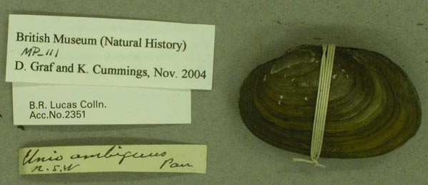
BMNH_MP_111
N.S.W.
| 
AMS_127152
Nana Creek, tributary of Nymboida and Clarence Rivers, New South Wales, Australia [-30.167, 152.967 ± 10 km]
| 
UMMZ_22866
Narrabri, Australia
| 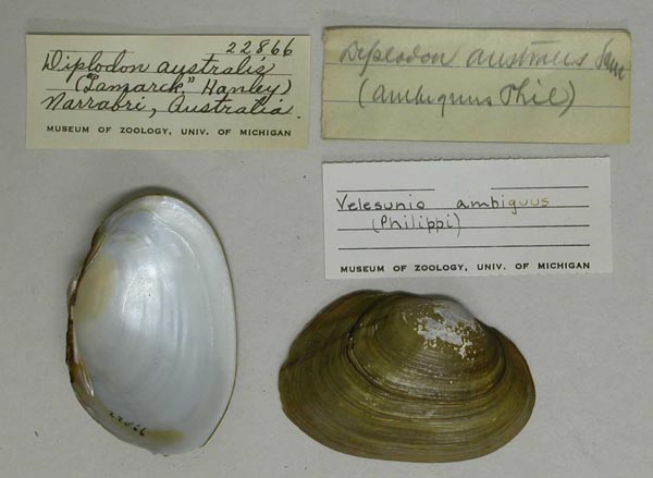
UMMZ_22866
Narrabri, Australia
| 
USNM_127250
Narribri, New South Wales
| 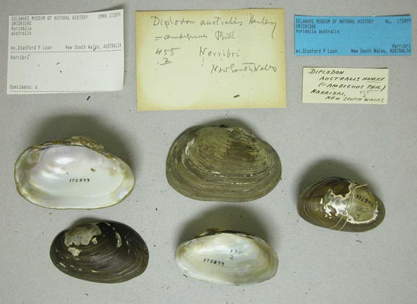
DMNH_172899
Narribri, New South Wales, Australia
| 
BMNH_MP_135
Narribri, NSW
| 
AMS_61694
near Dalby, Condamine R, Queensland, Australia [-27.225, 151.167 ± 1 km]
| 
AMS_61672
Near Roma, Yuleba Ck, trib of Balonne R, Queensland, Australia [-26.65, 149.408 ± 1 km]
| 
AMS_61690
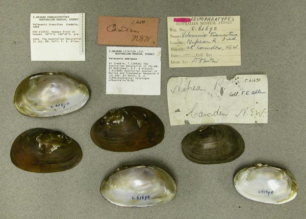
Nepean River nr Camden, New South Wales, Australia [-34.067, 150.7 ± 10 km]
| 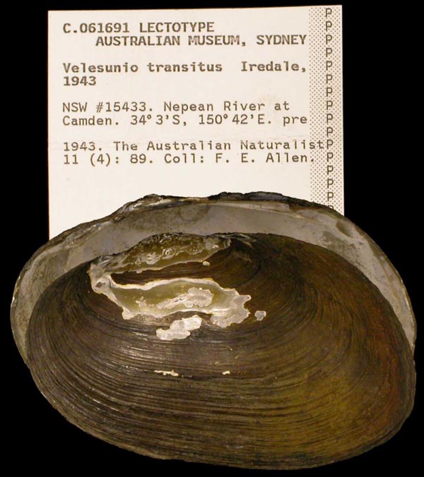
AMS_61691
Nepean River nr Camden, New South Wales, Australia [-34.067, 150.7 ± 10 km]
| 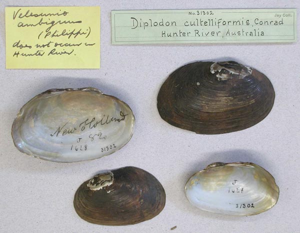
AMNH_31302
New Holland
| 
USNM_126526
New Holland
| 
USNM_126526
New Holland
| 
ZMB_MP_0444
New South Wales
| 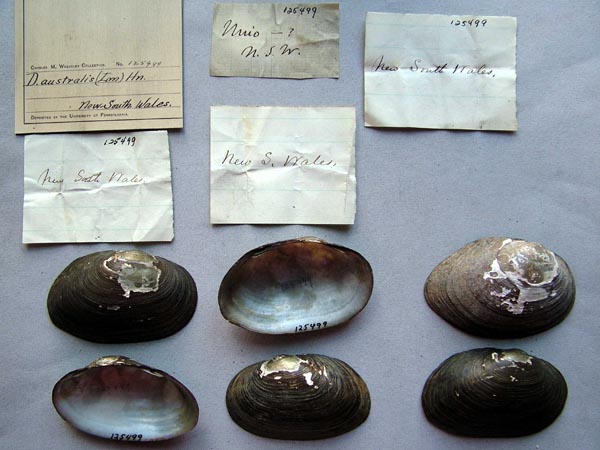
ANSP_125499
New South Wales
| 
BMNH_MP_080
New South Wales
| 
UMMZ_111797
New South Wales, Australia
| 
UMMZ_111797
New South Wales, Australia
| 
UMMZ_111851
New South Wales, Australia
| 
UMMZ_111851
New South Wales, Australia
| 
USNM_170111
New South Wales, Australia
| 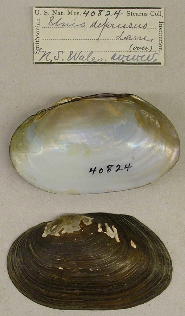
USNM_40824
New South Wales, Australia
| 
USNM_40824
New South Wales, Australia
| 
USNM_40809
New South Wales, Australia
| 
USNM_85720
New South Wales, Australia
| 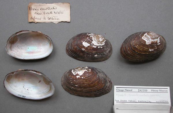
FMNH_142709
New South Wales, Australia
| 
UMMZ_111909
New South Wales, Australia
| 
UMMZ_111909
New South Wales, Australia
| 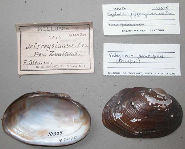
UMMZ_111825
New Zealand [crossed out — must be Australia]
| 
UMMZ_111825
New Zealand [crossed out — must be Australia]
| 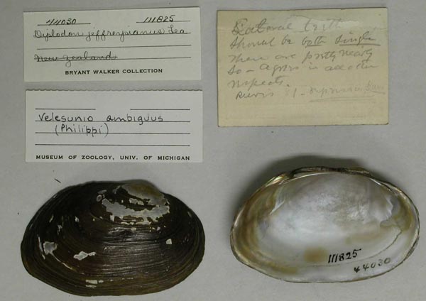
UMMZ_111825
New Zealand [crossed out — must be Australia]
| 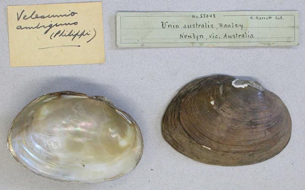
AMNH_55048
Newlyn, Victoria, Australia
| 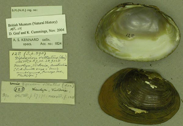
BMNH_MP_114
Newlyn, Victoria, Australia
| 
AMNH_115753
North Lake, Barmera, South Australia
| 
FMNH_21732
North Lake, Barmera, South Australia
| 
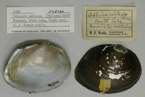
UMMZ_248766
North Lake, Barmera, South Australia
| 
UMMZ_248766
North Lake, Barmera, South Australia
| 
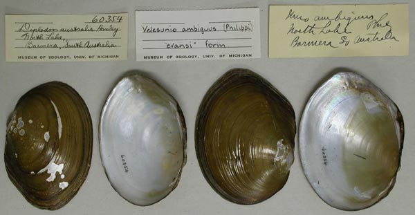
UMMZ_60354
North Lake, Barmera, South Australia
| 
UMMZ_60354
North Lake, Barmera, South Australia
| 
FMNH_120675
North Lake, South Australia
| 
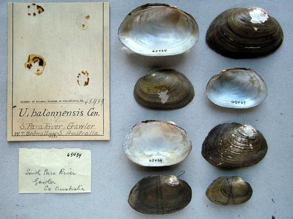
ANSP_65436
North Para River, S. Australia
| 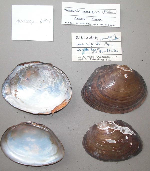
UMMZ_MP.603.1
North part of Australia
| 
UMMZ_MP.603.1
North part of Australia
| 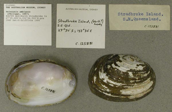
AMS_125881
North Stradbroke Is, Queensland, Australia [-27.583, 153.408 ± 1 km]
| 
MNHN_MP_1537
Nuelle Holland
| 
MNHN_MP_1516
Nuelle Holland
| 
USNM_623286
Nullah Gully, 60 miles N Chinchilla, Queensland, Australia; Burnett Watershed
| 
USNM_623286
Nullah Gully, 60 miles N Chinchilla, Queensland, Australia; Burnett Watershed
| 
BMNH_88-3-23-34
Numoi [?] River, NSW
| 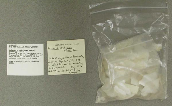
AMS_109977
NW of Balranald, Lake Arumpo, Top Hut Site, New South Wales, Australia [-33.8, 142.9 ± 10 km]
| 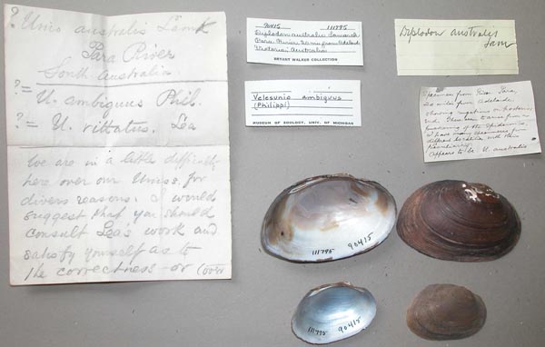
UMMZ_111795
Para River, 20 mi from Adelaide, Victoria, Australia
| 
UMMZ_111795
Para River, 20 mi from Adelaide, Victoria, Australia
| 
ANSP_71736
Para River, Australia
| 
AMS_400911
Paroo R, billabong 3km W of Wanaaring (Billabong), New South Wales, Australia [-29.707, 144.129 ± 100 m]
| 
AMS_61683
Peel River at Tamworth, New South Wales, Australia [-31.092, 150.933 ± 10 km]
| 
AMS_126261
Perrys Creek, 16 mi NW Mackay, northern Queensland
| 
USNM_623355
pond (billabong) approx. 5 miles W of Narranderra, Hay Road, New South Wales, Australia
| 
USNM_623355
pond (billabong) approx. 5 miles W of Narranderra, Hay Road, New South Wales, Australia
| 
BMNH_91-11-6-103-5
Port Curtis, Queensland
| 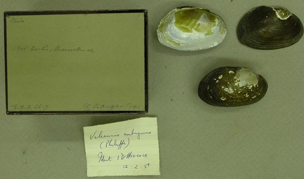
BMNH_86-12-3-66-67
Port Curtis, Queensland
| 
AMS_47293
Port Curtis, Queensland, Australia [-23.917, 151.383 ± 10 km]
| 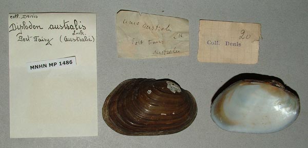
MNHN_MP_1486
Port Fairy, Australia
| 
ZMB_46009
Queensland
| 
USNM_879575
Queensland, Australia
| 
AMS_126233
Raglan Creek, 44 mi S Rockhampton, Queensland
| 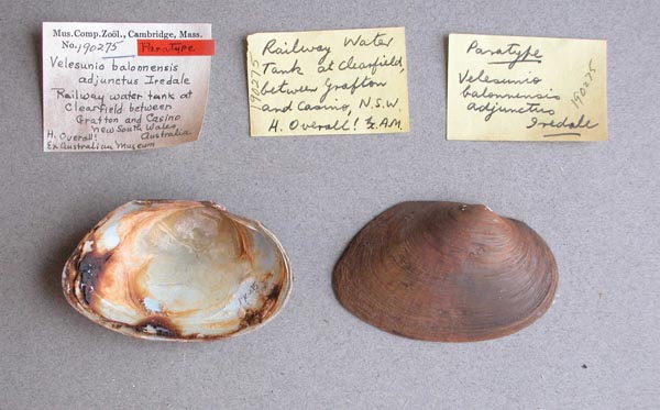
MCZ_190275
Railway water tank at Clearfield, between Grafton and Casino, New South Wales, Australia
| 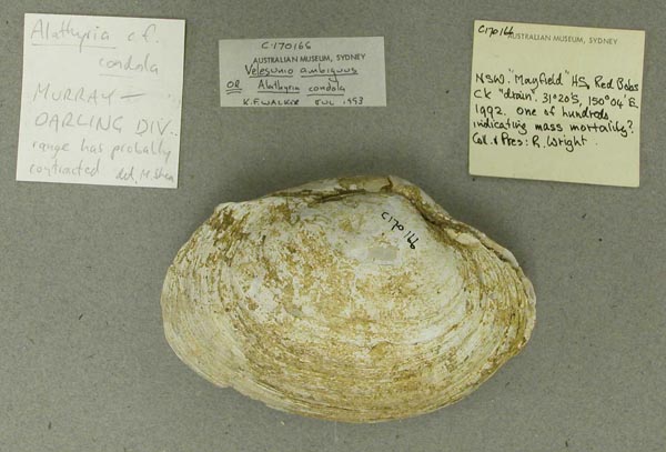
AMS_170166
Red Babs Creek, “Mayfield” HS, New South Wales, 31°20’S, 150°04’E
| 
DMNH_172900
reservoir, Newlyn, Victoria, Australia
| 
DMNH_172990
reservoir, Newlyn, Victoria, Australia
| 
BMNH_89-10-25-45-47
Richmond River
| 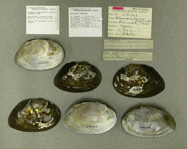
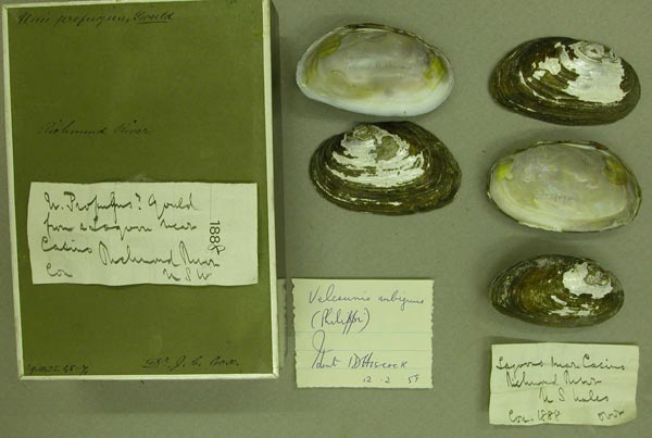
AMS_61708
Richmond River (Lagoon), New South Wales, Australia [-28.867, 153.05 ± 100 km]
| 
AMS_167440
Richmond River at Casino, upstream from Irving Bridge (Gravel & small rock pools), New South Wales, Australia [-28.869, 153.042 ± 1 km]
| 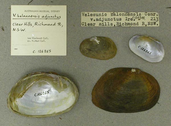
AMS_126265
Richmond River, Clear Hills, New South Wales
| 
ANSP_334434
Richmond River, N.S. Wales
| 
ZMB_MP_0459
Richmond River, New South Wales
| 
ZMB_19079
Richmond River, New South Wales, Australia
| 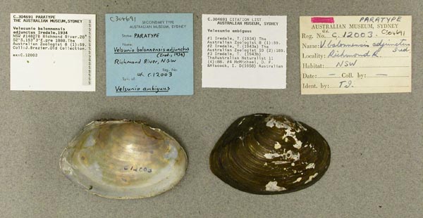
AMS_304691
Richmond River, New South Wales, Australia [-28.867, 153.05 ± 100 km]
| 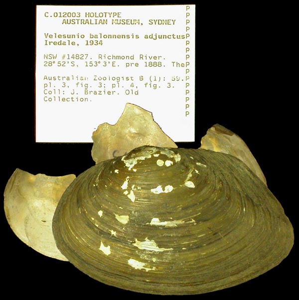
AMS_12003
Richmond River, New South Wales, Australia [-28.867, 153.05 ± 100 km]
| 
MNHN_MP_1506
River Avoca, Victoria
| 
FMNH_21733
River Lachlan, Hillston, New South Wales, Australia
| 
MNHN_MP_1464
River Murray
| 
USNM_16489
River Murray and [locality illegible] S Austr.
| 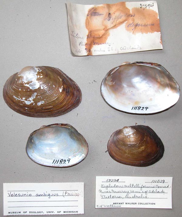
UMMZ_111829
River Murray, 80 mi E Adelaide, Victoria, Australia
| 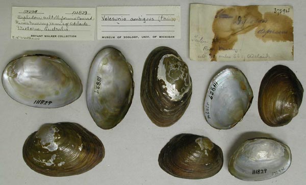
UMMZ_111829
River Murray, 80 mi E Adelaide, Victoria, Australia
| 
MCZ_37527
River Onkaparinga, South Australia, Australia
| 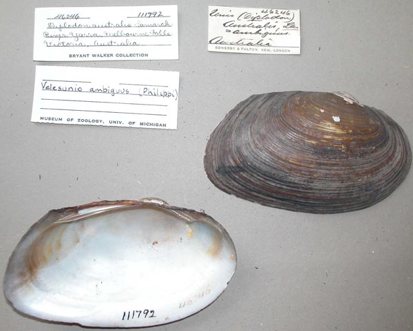
UMMZ_111792
River Yarra, Melbourne Falls, Victoria, Australia
| 
UMMZ_111792
River Yarra, Melbourne Falls, Victoria, Australia
| 
ZMB_MP_0428
River Yarra, Victoria
| 
ANSP_41802
River Yarra, Victoria, Australia
| 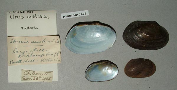
MNHN_MP_1476
Rockhampton
| 
AMS_125875
Rockhampton, Fitzroy R Basin, Queensland, Australia [-23.333, 150.5 ± 1 km]
| 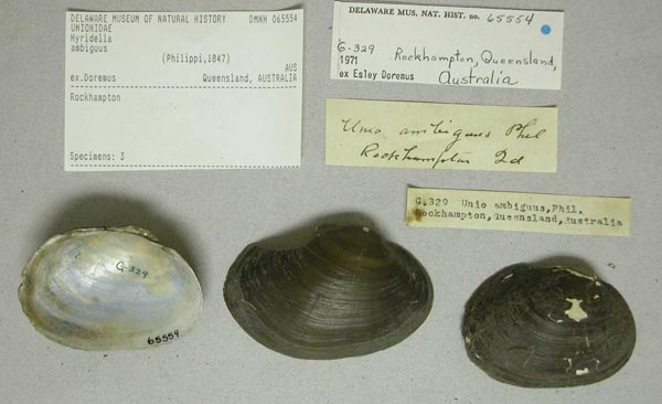
DMNH_65554
Rockhampton, Queensland, Australia
| 
AMS_61725
Rockhampton, Queensland, Australia [-23.367, 150.533 ± 10 km]
| 
BMNH_86-7-26-321-324
Ropes Creek, near Rooty Hill, NSW
| 
AMS_57879
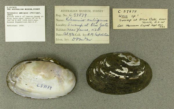
S of Leeton, Swamp at Blue Gate, near Yanco, New South Wales, Australia [-34.6, 146.4 ± 10 km]
| 
AMS_126239
S of Rockhampton, Gavial Ck, Queensland, Australia [-23.075, 150.858 ± 10 km]
| 
AMS_126235
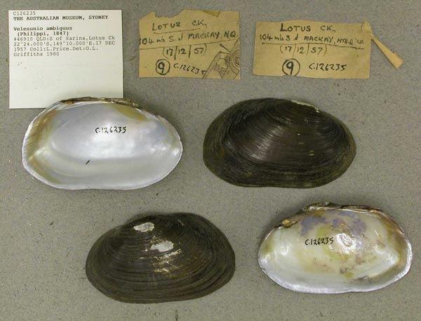
S of Sarina, Lotus Ck, Queensland, Australia [-22.4, 149.167 ± 10 km]
| 
ANSP_71734
S. Australia
| 
ANSP_71734
S. Australia
| 
ANSP_65434
S. Para River, Gawler, S. Australia
| 
USNM_623344
Samford, Queensland, Australia
| 
USNM_623344
Samford, Queensland, Australia
| 
AMS_125810
SE of Cowra, Wyangala Dam, New South Wales
| 
AMS_61704
Serpentine River, Loddon District, Victoria, Australia [-36.217, 143.933 ± 100 km]
| 
BMNH_46-9-16-76
South Australia
| 
BMNH_46-9-16-76
South Australia
| 
AMNH_35337
South Australia
| 
UMMZ_111796
South Australia
| 
UMMZ_111796
South Australia
| 
UMMZ_111796
South Australia
| 
ANSP_341440
South Australia
| 
ANSP_341442
South Australia
| 
ANSP_341442
South Australia
| 
ANSP_341443
South Australia
| 
UMMZ_111826
South Australia
| 
UMMZ_111826
South Australia
| 
FMNH_24521
South Australia
| 
FMNH_90074
South Australia
| 
BMNH_50-9-25-116
South Creek, Australia
| 
BMNH_50-9-25-116
South Creek, Australia
| 
BMNH_88-3-23-2-5
South Creek, County of Cumberland, NSW
| 
BMNH_88-3-23-6-10
South Creek, County of Cumberland, NSW
| 
BMNH_88-3-23-1
South Creek, County of Cumberland, NSW
| 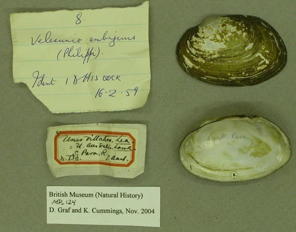
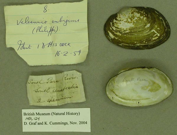
BMNH_MP_124
South Para River, South Australia
| 
BMNH_MP_124
South Para River, South Australia
| 
BMNH_MP_125
South Para River, South Australia
| 
AMS_125888
St George, Balonne R, Queensland, Australia [-28.05, 148.583 ± 10 km]
| 
BMNH_88-3-23-14-16
Stanley River, Queensland
| 
AMS_463
Stawell, Victoria, Australia [-37.06, 142.777 ± 1 km]
| 
AMS_2698
Summer Hill Creek at Lucknow near Orange, New South Wales, Australia [-33.35, 149.167 ± 1 km]
| 
AMS_125812
Sydney W, Eastern Creek, New South Wales, Australia [-33.822, 150.861 ± 10 km]
| 
AMS_126267
Sydney W, Nepean River near bridge, New South Wales, Australia [-33.75, 150.675 ± 100 km]
| 
AMS_125870
Sydney W, South Ck, trib. of Hawkesbury R, New South Wales, Australia [-33.717, 150.767 ± 100 km]
| 
ZMB_18668
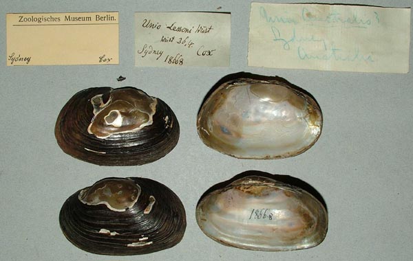
Sydney, Australia
| 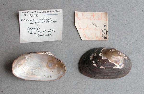
MCZ_72081
Sydney, New South Wales, Australia
| 
AMS_126281
Talbragar River, Cobbora, New South Wales, Australia [-32.05, 149.25 ± 1 km]
| 
AMS_137217
Talgarno, Hume Weir, Victoria, Australia [-36.063, 147.158 ± 1 km]
| 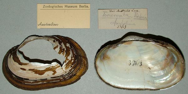
ZMB_37613
Toowoomba, Victoria, Australia
| 
SBMHN_367472
Torrens River, South Australia
| 
MCZ_191954
tributary of Murrumbidgee River, at Griffith, New South Wales, Australia
| 
AMS_84254
Trickiten Creek, Narran River, Angledool, N of Lightning Ridge (On creek bank), New South Wales, Australia [-29.1, 147.9 ± 1 km]
| 
AMS_84254
Trickiten Creek, Narran River, Angledool, N of Lightning Ridge (On creek bank), New South Wales, Australia [-29.1, 147.9 ± 1 km]
| 
BMNH_MP_103
Upper Falls of the River Yarra, Melbourne, Victoria
| 
BMNH_57-11-18-29
Upper Victoria
| 
BMNH_57-11-18-29
Upper Victoria
| 
BMNH_MP_074
Victoria
| 
BMNH_MP_105
Victoria and Yeppoon Lagoon, Queensland
| 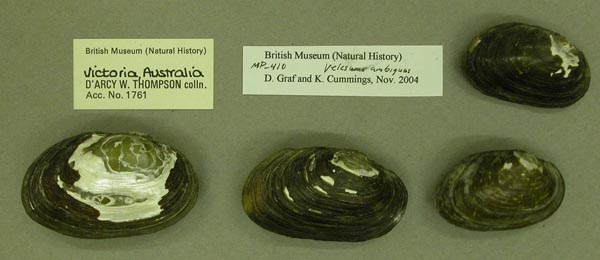
BMNH_MP_410
Victoria, Australia
| 
UMMZ_111791
Victoria, Australia
| 
UMMZ_111791
Victoria, Australia
| 
FMNH_11202
Victoria, Australia
| 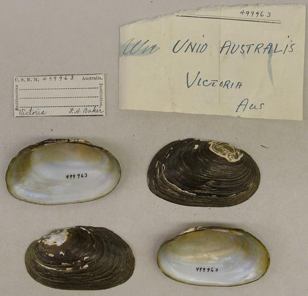
USNM_499963
Victoria, Australia
| 
AMS_125894
W of Walgett, Lake Narran (Lake edge), New South Wales, Australia [-29.867, 147.317 ± 10 km]
| 
AMS_68931
W of Yeppoon, Lake Mary, Queensland, Australia [-23.117, 150.592 ± 1 km]
| 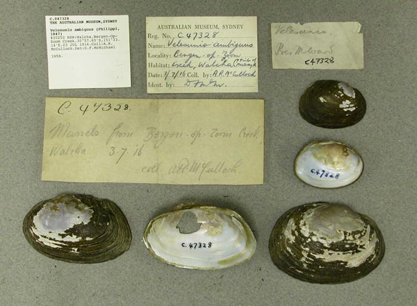
AMS_47328
Walcha, Bergen-Op-Zoom Creek, New South Wales, Australia [-30.961, 151.552 ± 10 km]
| 
BMNH_91-11-6-283-294
Wallondilly River, Goulburn, NSW
| 
BMNH_20000228
Waranga Dam, Goulburn Valley, Australia
| 
AMS_61664
Warrego River at Charleville, Queensland, Australia [-26.4, 146.238 ± 10 km]
| 
AMS_6503
Warren, Macquarie Rr, Gunningbar Ck, New South Wales, Australia [-31.717, 147.849 ± 10 km]
| 
AMS_61697
Watalgan, near Bundaberg, Queensland, Australia [-24.65, 152.017 ± 10 km]
| 
AMS_62158
waterhole, Monet Estate, Rockhampton, Queensland
| 
FMNH_142710
Watson’s Creek, Greensborough, Victoria, Australia
| 
MCZ_191129
Watson’s Creek, Victoria, Australia
| 
DMNH_78610
Watsons Creek, Greensburough, Victoria, Australia
| 
UMMZ_111899
Watsons Creek, Victoria, Australia
| 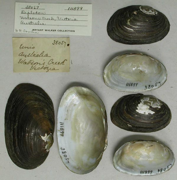
UMMZ_111899
Watsons Creek, Victoria, Australia
| 
AMS_62030
Weetaliba near Binnaway, New South Wales, Australia [-31.578, 149.596 ± 1 km]
| 
BMNH_MP_109
Werribee River, Ballan, Victoria, Australia
| 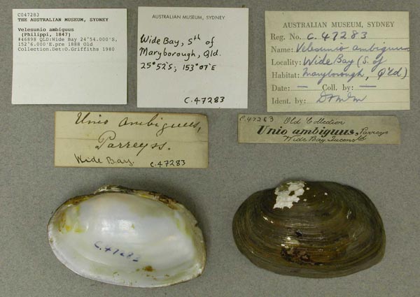
AMS_47283
Wide Bay, Queensland, Australia [-24.9, 152.1 ± 10 km]
| 
AMS_141795
Willandra Nat. Park, near Willandra Homestead (On banks of billabong), New South Wales, Australia [-33.19, 145.118 ± 10 km]
| 
AMS_126325
Willandra, New South Wales, Australia [-33.195, 145.155 ± 1 km]
| 
AMS_61707
Wimmera River at Horsham, Victoria, Australia [-36.717, 142.2 ± 10 km]
| 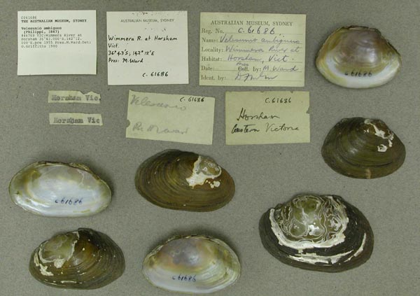
AMS_61686
Wimmera River at Horsham, Victoria, Australia [-36.717, 142.2 ± 10 km]
| 
AMS_87452
WNW of Inverell, SSE of Warialda, "Yuruga" Stn (In eroded creek bank, 2.5-3m below present level of land), New South Wales, Australia [-29.593, 150.593 ± 1 km]
| 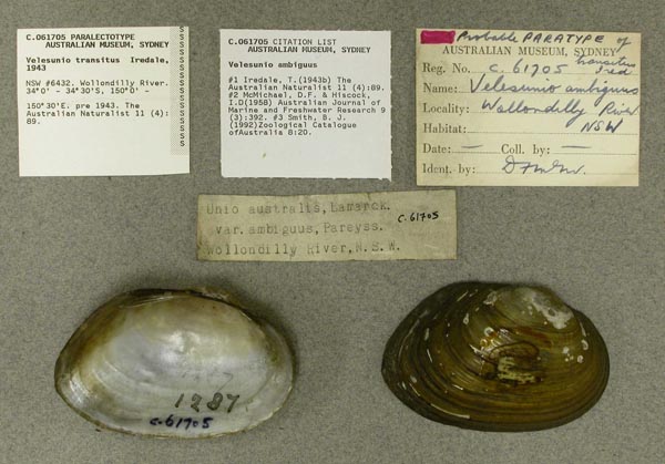
AMS_61705
Wollondilly River, New South Wales, Australia [-34, 150 ± 100 km]
| 
AMS_47289
Wollondilly River, New South Wales, Australia [-34.283, 149.567 ± 100 km]
| 
AMS_47300
Yarra River at Princes Bridge, Melbourne, Victoria, Australia [-37.807, 144.957 ± 1 km]
| 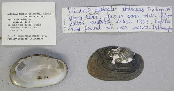
AMNH_261810
Yarra River, Australia
| 
ANSP_125841
Yarra River, Australia
| 
BMNH_MP_406
Yarra River, Melbourne, Australia
| 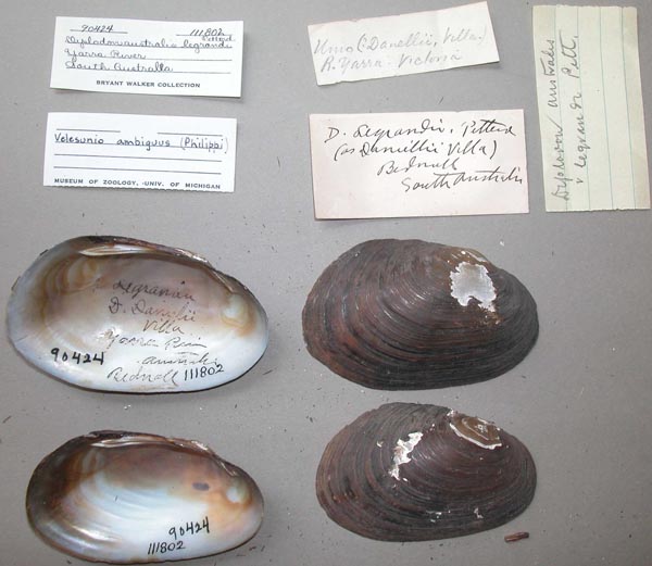
UMMZ_111802
Yarra River, South Australia
| 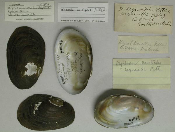
UMMZ_111802
Yarra River, South Australia
| 
AMS_47292
Yarra River, Victoria, Australia [-37.833, 145 ± 100 km]
| 
AMS_47288
Yarra River, Victoria, Australia [-37.833, 145 ± 100 km]
| 
AMS_47288B
Yarra River, Victoria, Australia [-37.833, 145 ± 100 km]
| 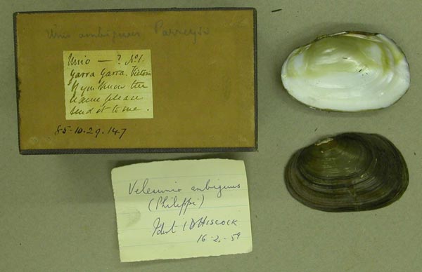
BMNH_85-10-29-147
Yarra Yarra River, Victoria
| 
AMS_61886
Yeppen, near Rockhampton, Murray Lagoon, Queensland, Australia [-23.417, 150.5 ± 10 km]
| 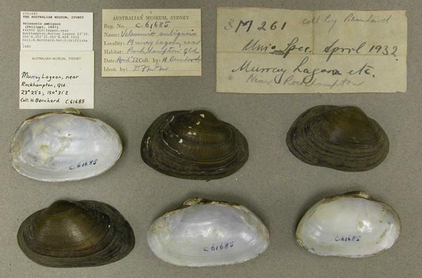
AMS_61685
Yeppen, near Rockhampton, Murray Lagoon, Queensland, Australia [-23.417, 150.5 ± 10 km]
| 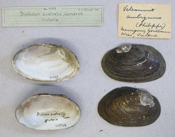
AMNH_35528
Youlbourne Weir, Merrigum, Victoria, Australia
|
BMNH_MP_095. [no locality available - Australia] AMS_125969. [presumably Australia] AMS_75140. 16 km SW of Gladstone (Open gum forest), Queensland, Australia [-24, 151.217 ± 10 km] AMS_100842. 16 km SW of Wee Waa,on Pilliga Rd, Brigalow Creek, W side of bridge (On sandy mud around pool), New South Wales, Australia [-30.316, 149.294 ± 10 km] AMS_100841. 17 km S of Narrabri, Bohena Creek on Newell Highway E of road bridge (Round pool on sand/mud), New South Wales, Australia [-30.447, 149.671 ± 1 km] AMS_396515. 17 km S of Narrabri, Bohena Creek on Newell Highway, 100m E of road bridge (In sandy mud, in isolated pools), New South Wales, Australia [-30.447, 149.671 ± 1 km] AMS_404110. 2 small billabongs on E side of Macquarie R near Willancorah Stn (4km from `main rd') Macquarie Marshes (on leaves on bottom of pool), New South Wales, Australia [-30.9, 147.5 ± 1 km] AMS_110102. 20 km S of Forbes, on Newell Hwy (River or billabong), New South Wales, Australia [-33.49, 147.827 ± 10 km] AMS_74851. 23 km from Griffith (In swamp, 45m from edge), New South Wales, Australia [-34.283, 146.033 ± 100 km] AMS_404948. 25 km NW of Griffith, Willow Dam - Barren Box Swamp, drainage channel (Channel with soft mud, plants, flowing), New South Wales, Australia [-34.183, 145.828 ± 1 km] AMS_173356. 30km N of Maryborough, SW of Howard, Upper Burrum R, Harwood Ck (In creek bed & on banks), Queensland, Australia [-25.433, 152.483 ± 10 km] AMS_422519. 6 miles W of Stawell, Victoria, Australia [-37.05, 142.725 ± 10 km] AMS_421788. Alice R, "North Delta" HS (Dry creek bed), Queensland, Australia [-23.669, 145.589 ± 100 m] AMS_433214. approx 20km S of Walcha, Apsley R, opposite "Pine Glen" HS, New South Wales, Australia [-31.187, 151.652 ± 1 km] AMS_173490. Approx 91km NE of Miles, 4km W of Wandoan, Queensland, Australia [-26.133, 149.917 ± 10 km] AMS_149368. Apsley River, above Apsley Falls, Apsley Gorge National Park (rocky bottom, on bank), New South Wales, Australia [-31.052, 151.768 ± 1 km] AMS_126125. Archers, Gracemere, near Rockhampton, Queensland, Australia [-23.433, 150.45 ± 10 km] AMS_381213. Balonne R, at Bindle, Queensland, Australia [-27.667, 148.75 ± 10 km] AMS_404102. Baranbah Ck, on side rd from Ban Ban Springs, at ford (near Research Stn) & Ban Ban HS (Under rocks & in creek), Queensland, Australia [-25.685, 151.778 ± 100 m] AMS_327362. Barton Creek, just S of Roma-Taroom Rd (Billabing at side of creek, in flood debris and mud along edges), Queensland, Australia [-26.057, 149.256 ± 100 m] AMS_396519. Bathurst, Sir Joseph Banks Nature Park (In dam), New South Wales, Australia [-33.433, 149.575 ± 10 km] AMS_125848. Beaudesert, Logan River, Walkers Lagoon, Queensland, Australia [-27.983, 153 ± 10 km] AMS_125891. Bective, Peel River, near Tamworth (Lagoon), New South Wales, Australia [-30.97, 150.735 ± 10 km] AMS_334243. Billabong on road between Munginda and St George (on wood), Queensland, Australia [-28.513, 148.846 ± 100 m] AMS_314469. Billabong, Paroo River, New South Wales, Australia [-29.707, 144.129 ± 100 m] AMS_61681. Bogan River near Nyngan, New South Wales, Australia [-31.567, 147.2 ± 10 km] AMS_126375. Boggabilla, Queensland, Australia [-28.617, 150.367 ± 10 km] AMS_396520. Bohena Ck, 11km from Narrabri, on Culgoora Rd, 300m S of rail bridge. (In residual pools), New South Wales, Australia [-30.325, 149.69 ± 1 km] AMS_396521. Bohena Ck, 11km from Narrabri, on Culgoora Rd, 300m S of rail bridge., New South Wales, Australia [-30.325, 149.69 ± 1 km] AMS_404958. Booberoi Ck, between Lake Cargelligo & Mt. Hope, New South Wales, Australia [-33.138, 146.29 ± 10 km] AMS_396517. Box Creek, Cohuna, Victoria, Australia [-35.917, 144.217 ± 10 km] AMS_126344. Brewarrina, Barwon River, New South Wales, Australia [-29.95, 146.867 ± 10 km] AMS_126395. Brewarrina, Barwon River, New South Wales, Australia [-29.95, 146.867 ± 10 km] AMS_396513. Brigalow Creek, 50m W of road bridge on Wee Waa - Pillaga Rd (Isolated residual pool), New South Wales, Australia [-30.312, 149.293 ± 1 km] AMS_125847. Brisbane, Belmont, Queensland, Australia [-27.517, 153.117 ± 10 km] AMS_430726. Brisbane, Norman Creek near Holland Park, Queensland, Australia [-27.5, 153.067 ± 10 km] AMS_430724. Brisbane, Rocklea, Queensland, Australia [-27.548, 153.005 ± 1 km] AMS_430690. Broken River at Swanpool, Victoria, Australia [-36.746, 146.008 ± 1 km] AMS_125873. Bulloo R at Thargomindah, Queensland, Australia [-27.983, 143.817 ± 10 km] AMS_430723. Bulloo R at Thargomindah, Queensland, Australia [-27.983, 143.817 ± 10 km] AMS_422338. ca 6.5km (4mls) E of Wodonga, on Wodonga-Tallangatta rd, swampy ck flowing into Murray R (In mud), Victoria, Australia [-36.14, 146.955 ± 1 km] AMS_404951. ca. 30.5km (19mls) NW of Lake Cargelligo (Muddy bank of drying creek), New South Wales, Australia [-33.208, 146.367 ± 10 km] AMS_110101. Cargelligo Weir, near "Sheet of Water" Lake, New South Wales, Australia [-33.202, 146.451 ± 1 km] AMS_126311. Casino, Richmond River, New South Wales, Australia [-28.867, 153.033 ± 10 km] AMS_435774. Clarence R, at Baryulgil crossing, New South Wales, Australia [-29.217, 152.562 ± 1 km] AMS_404949. Clarence River upper reaches at Woodenbong, New South Wales, Australia [-28.383, 152.617 ± 10 km] AMS_380836. Condamine R, at Condamine (Found washed up on gravel sides in shoal area), Queensland, Australia [-26.928, 150.129 ± 100 m] AMS_421786. Condamine R, Condamine, below weir at bridge (Isolated pools in rocky sandy/gravel ck; under rocks at edge of pools.), Queensland, Australia [-26.926, 150.13 ± 100 m] AMS_61675. Condamine R, nr Cecil Plains, Queensland, Australia [-27.533, 151.2 ± 10 km] AMS_84892. Condobolin area, Booberoi (Booberi) Creek, around Round Hill Rd bridge, New South Wales, Australia [-33.139, 146.29 ± 100 km] AMS_404983. Condobolin area, Booberoi Ck, N side of Round Hill road bridge (Mostly buried in muddy substrate with numerous weed patches.), New South Wales, Australia [-33.139, 146.29 ± 100 km] AMS_73424. Creek near Mt. Harris, ca. 48km (30mls) N of Warren, New South Wales, Australia [-31.3, 147.667 ± 10 km] AMS_360011. Creswick, ca. 15km NW Ballarat (In dam), Victoria, Australia [-37.433, 143.9 ± 10 km] AMS_100839. Cudgegong River, N of Rylstone, 100m E of rail bridge (Gravel bottom with silt & reeds), New South Wales, Australia [-32.792, 149.971 ± 1 km] AMS_173156. Darling River at Kinchega National Park, Menindee (River bank), New South Wales, Australia [-32.399, 142.414 ± 10 km] AMS_125885. Darling River, just S of Menindee (In billabong), New South Wales, Australia [-32.4, 142.417 ± 1 km] AMS_404163. Dawson R at Taroom, Queensland, Australia [-25.645, 149.795 ± 100 m] AMS_421785. Dawson R, W of Springsure, off Dawson Hwy, nr Moura Weir, Queensland, Australia [-24.6, 149.91 ± 100 m] AMS_421793. Dawson R, W of Springsure, off Dawson Hwy, nr Moura Weir, Queensland, Australia [-24.6, 149.91 ± 100 m] AMS_173130. Deniliquin, Edward River, New South Wales, Australia [-35.533, 144.967 ± 10 km] AMS_61674. Deniliquin, Edward River, New South Wales, Australia [-35.533, 144.967 ± 10 km] AMS_126350. Deniliquin, Edward River, New South Wales, Australia [-35.533, 144.967 ± 10 km] AMS_426331. E of Rylstone, Cudgegong R, Rylstone Dam, at end of council access road (On mud at water's edge), New South Wales, Australia [-32.792, 149.985 ± 1 km] AMS_435772. Eastern Creek, opp Raceway, New South Wales, Australia [-33.822, 150.861 ± 10 km] AMS_341631. Elliot River on Isis Hwy (In sandy mud in small pools), Queensland, Australia [-25.014, 152.195 ± 100 m] AMS_91359. Esk, Brisbane River, Queensland, Australia [-27.233, 152.417 ± 10 km] AMS_404162. Fairy Bower, ca 6 mis SW of Rockhampton, Queensland, Australia [-23.403, 150.466 ± 1 km] AMS_126364. Fitzroy R at Duaringa, Queensland, Australia [-23.627, 150.108 ± 100 km] AMS_173137. Four Mile Creek, New England Highway, S of Tenterfield, New South Wales, Australia [-29.265, 149.986 ± 1 km] AMS_327791. Frogmore Lagoon, Rockhampton (under rocks and wood along edges[viviparids]; on wood [glyptophysa, segmentina and Lymnaea]), Queensland, Australia [-23.446, 150.539 ± 100 m] AMS_126367. Georges River near Sydney, New South Wales, Australia [-33.95, 150.8 ± 100 km] AMS_126406. Georges River near Sydney, New South Wales, Australia [-33.95, 150.8 ± 100 km] AMS_126335. Gilgandra, Castlereagh River, New South Wales, Australia [-31.717, 148.667 ± 10 km] AMS_173143. Gilgandra, Castlereagh River, New South Wales, Australia [-31.717, 148.667 ± 10 km] AMS_430727. Gladstone, Queensland, Australia [-23.863, 151.234 ± 10 km] AMS_430695. Goulburn River at Longwood, Victoria, Australia [-36.8, 145.417 ± 10 km] AMS_61688. Goulburn, New South Wales, Australia [-34.761, 149.72 ± 10 km] AMS_396518. Griffith, New South Wales, Australia [-34.283, 146.033 ± 10 km] AMS_126392. Gundagai, Murrumbidgee River, New South Wales, Australia [-35.067, 148.117 ± 10 km] AMS_173155. Gundagai, Murrumbidgee River, New South Wales, Australia [-35.067, 148.117 ± 10 km] AMS_430730. Ipswich, Booval (Bundamba Creek), Queensland, Australia [-27.611, 152.805 ± 10 km] AMS_404103. Jordan R, at Jericho, on Capricorn Hwy (Alice R Drainage), Queensland, Australia [-23.599, 146.133 ± 100 m] AMS_404232. Jordan R, at Jericho, on Capricorn Hwy (Alice R Drainage), Queensland, Australia [-23.599, 146.133 ± 100 m] AMS_126402. Kalka Ck, near Rockhampton, Queensland, Australia [-23.383, 150.483 ± 100 km] AMS_173153. Kemps Creek, West of Hoxton Park, New South Wales, Australia [-33.933, 150.667 ± 10 km] AMS_409082. Kinchega Nat. Park, Lake Menindee (At edge of lake), New South Wales, Australia [-32.401, 142.369 ± 1 km] AMS_173141. Kinchega National Park, Menindee, New South Wales, Australia [-32.393, 142.418 ± 10 km] AMS_411607. Kinchega NP, at Ranger stn / Woolshed, New South Wales, Australia [-32.471, 142.346 ± 100 m] AMS_404160. Korenan, 60miles N. of Bundaberg, Queensland, Australia [-24.467, 151.667 ± 1 km] AMS_330863. Lagoon at Narrabri, New South Wales, Australia [-30.333, 149.783 ± 10 km] AMS_411612. Lake Boga, E of Swan Hill, Victoria, Australia [-35.453, 143.628 ± 100 m] AMS_126287. Leeton, New South Wales, Australia [-34.55, 146.4 ± 10 km] AMS_158379. Lion Creek, near Rockhampton, Queensland, Australia [-23.362, 150.478 ± 10 km] AMS_99285. Macquarie River, 5km N of Warren, New South Wales, Australia [-31.667, 147.805 ± 10 km] AMS_409083. Mallee Cliffs State Forest, Tributary of Murray River (At edge), New South Wales, Australia [-34.51, 142.413 ± 1 km] AMS_89051. Marra (=Murra) Ck, trib. of Macquarie R., NW of Warren, New South Wales, Australia [-31.217, 143.502 ± 10 km] AMS_100835. Marthaguy Ck., trib of Macquarie R, W of Carinda (On muddy banks), New South Wales, Australia [-30.457, 147.681 ± 10 km] AMS_396516. Menindee Lake, Kinchega National Park, Menindee (Along edge of water, in mud.), New South Wales, Australia [-32.392, 142.417 ± 10 km] AMS_421787. Miles, Chinamans Lagoon (billabong) (Under & on rocks & in weed at billabong edge.), Queensland, Australia [-26.669, 150.187 ± 100 m] AMS_61905. Mooni (Moonie) River at Mogil Mogil Homestead, New South Wales, Australia [-29.35, 148.683 ± 1 km] AMS_327358. Mooni River, Queensland, Australia [-28.343, 148.832 ± 100 m] AMS_308489. Moora Moora Reservoir, Grampians, Victoria, Australia [-37.233, 142.417 ± 1 km] AMS_404975. Mororo, on Don McLaren's property (Dam), New South Wales, Australia [-29.333, 153.233 ± 10 km] AMS_330381. Mount George, New South Wales, Australia [-31.883, 152.183 ± 10 km] AMS_173162. Mulwaree Ponds, Goulburn, New South Wales, Australia [-34.783, 149.667 ± 10 km] AMS_62161. Murray Lagoons, Rockhampton, Queensland, Australia [-23.367, 150.517 ± 1 km] AMS_125916. Murray River at Mannum, Southern Australia, Australia [-34.917, 139.3 ± 1 km] AMS_358674. Murrumbidgee River at Wagga Wagga, New South Wales, Australia [-35.117, 147.383 ± 10 km] AMS_419925. N of Bourke, E side of Mitchell Hwy, Warrego R overflow (Waterholes), New South Wales, Australia [-29.349, 145.863 ± 100 m] AMS_99503. Namoi River, Narrabri, Old Gunedah Rd, Tarriaro (=Terriara) Bridge (On mud bank in river), New South Wales, Australia [-30.396, 149.894 ± 1 km] AMS_327365. Narran Lake (shallow, muddy pools), New South Wales, Australia [-29.698, 147.438 ± 100 m] AMS_126448. Narrandera, Murrumbidgee River, New South Wales, Australia [-34.751, 146.546 ± 10 km] AMS_61899. Narrandera, near Lake Talbot (irrigation channel), New South Wales, Australia [-34.751, 146.567 ± 10 km] AMS_430729. Near Roma, Yuleba Creek at Yuleba, off Balonne R, Queensland, Australia [-26.613, 149.383 ± 1 km] AMS_404962. Nenegara waterhole, Paroo Rd. at Wanaaring, New South Wales, Australia [-29.7, 144.15 ± 10 km] BMNH_59-10-12-104-106. Nepean and Bogan rivers, Australia AMS_432617. Nepean R, Menangle Bridge, New South Wales, Australia [-34.119, 150.739 ± 100 m] AMS_432611. Nepean River at Douglas Park, New South Wales, Australia [-34.194, 150.712 ± 10 km] AMS_174671. Nepean River, Camden, New South Wales, Australia [-34.05, 150.7 ± 10 km] AMS_358670. Nepean River, Camden, New South Wales, Australia [-34.073, 150.699 ± 10 km] AMS_173349. Nepean River, Menangle (buried in gravel in pond, low river level), New South Wales, Australia [-34.133, 150.748 ± 1 km] AMS_358667. Nepean River, Menangle, New South Wales, Australia [-34.119, 150.737 ± 10 km] AMS_127154. NW of Miriam Vale, approx 7mls NNW of Bororen (In waterhole), Queensland, Australia [-24.317, 151.542 ± 10 km] AMS_434727. Paddys R at Hume Hwy (Pool with soft mud bottom), New South Wales, Australia [-34.647, 150.125 ± 1 km] AMS_414984. Paddys R, under freeway bridge (=Hume Hwy bridge?) (Silt on pool bottom), New South Wales, Australia [-34.643, 150.125 ± 1 km] AMS_404101. Paroo R, 1km N of Hungerford, on Hwy between Hungerford & Eulo (Series of pools & mud in otherwise dry riverbed.), Queensland, Australia [-28.983, 144.407 ± 100 m] AMS_404107. Paroo R, 1km N of Hungerford, on Hwy between Hungerford & Eulo (Series of pools & mud in otherwise dry riverbed.), Queensland, Australia [-28.983, 144.407 ± 100 m] AMS_47287. Port Curtis, Queensland, Australia [-23.917, 151.383 ± 10 km] AMS_303838. Rickabys Creek, near Londonderry, Sydney (On dry bank near pool & 5-25cm below surface in dry bed), New South Wales, Australia [-33.648, 150.752 ± 10 km] AMS_379936. Rockhampton, Queensland, Australia [-23.367, 150.533 ± 10 km] AMS_125874. Roma, Queensland, Australia [-26.583, 148.783 ± 10 km] AMS_379935. Sandy Creek Bridge on Juandah Creek on Roma - Taroom Rd (in drying pool), Queensland, Australia [-25.68, 149.804 ± 100 m] AMS_420520. Sandy Creek Bridge on Juandah Creek on Roma - Taroom Rd (in drying pool), Queensland, Australia [-25.68, 149.804 ± 100 m] AMS_404968. SE of Cowra, Wyangala Dam, New South Wales, Australia [-33.971, 148.95 ± 1 km] AMS_100750. SE of Narrabri, junction of Namoi River and Bibbla Creek, New South Wales, Australia [-30.448, 149.946 ± 1 km] AMS_100840. SE of Narrabri, Tulla Mullen (=Mallin) Creek, New South Wales, Australia [-30.589, 149.886 ± 10 km] AMS_425848. Severn R at rd to Macintyre Falls, New South Wales, Australia [-29.152, 150.967 ± 10 km] AMS_125815. South Creek near Sydney, New South Wales, Australia [-33.817, 150.767 ± 100 km] AMS_61670. South Grafton, Bardens(?) Creek, New South Wales, Australia [-29.7, 152.933 ± 1 km] AMS_140519. SW of Gympie, Eel Ck, on Eel Ck Rd (Small weedy creek with sandy bottom), Queensland, Australia [-26.231, 152.633 ± 1 km] AMS_404947. Sydney NW, Beecroft reservoir, New South Wales, Australia [-33.75, 151.067 ± 10 km] AMS_61898. Sydney W, Eastern Creek, at Quakers Hill, New South Wales, Australia [-33.73, 150.87 ± 10 km] AMS_71392. Sydney W, Prospect, Eastern Creek (Small sluggish heavily polluted creek), New South Wales, Australia [-33.792, 150.863 ± 1 km] AMS_125917. Tailem Bend, River Murray, Southern Australia, Australia [-35.25, 139.467 ± 10 km] AMS_435769. Talbragar R at Boomey Rd, New South Wales, Australia [-32.108, 149.092 ± 1 km] AMS_100753. Talbragar River, 1km N of Dunedoo (Mud & gravel), New South Wales, Australia [-32, 149.4 ± 10 km] AMS_61702. Tamworth, New South Wales, Australia [-31.102, 150.925 ± 10 km] AMS_125872. Thallon, Queensland, Australia [-28.633, 148.867 ± 10 km] AMS_126257. Thargomindah, Queensland, Australia [-27.983, 143.817 ± 10 km] AMS_314488. Trangie, WNW of Dubbo (billabongs), New South Wales, Australia [-32.034, 147.988 ± 100 m] AMS_419924. Tuen Ck, next to Mitchell Hwy, creek crossing (Under rocks at edge of pools in creek bed.), Queensland, Australia [-28.565, 145.713 ± 100 m] MNHN_MP_1476_2. Victoria AMS_126106. W of Coonamble, "Mutamaa" ="Muttama" Stn, near Garrawilla Watercourse, bore dam, New South Wales, Australia [-30.908, 148.045 ± 10 km] AMS_409084. W of Wentworth, Rufus River, adjacent to outflow from Lake Victoria (In water weed), New South Wales, Australia [-34.05, 141.276 ± 100 m] AMS_311534. Walcha, S. side of town, Apsley Rd (Small river, sand, rock, gravel & some mud in side pools.), New South Wales, Australia [-30.988, 151.593 ± 100 m] AMS_126353. Walgett, Barwon River, New South Wales, Australia [-30.183, 148.118 ± 10 km] AMS_173147. Walgett, billabong near Barwon River, New South Wales, Australia [-30.016, 148.118 ± 10 km] AMS_126390. Walgett, near Barwon River (Billabong), New South Wales, Australia [-33.016, 148.118 ± 10 km] AMS_126291. Walgett, New South Wales, Australia [-30.183, 148.118 ± 10 km] AMS_173131. Walla Walla, near Albury, New South Wales, Australia [-35.767, 146.9 ± 10 km] AMS_126333. Ward R, 12mls W of Charleville, Queensland, Australia [-26.333, 145.583 ± 10 km] AMS_314481. Warrego R at Charleville, Queensland, Australia [-28.019, 145.749 ± 100 m] AMS_430722. Warrego River at Charleville, Queensland, Australia [-26.4, 146.238 ± 10 km] AMS_125864. Warwick, Queensland, Australia [-28.217, 152.033 ± 10 km] AMS_125865. Warwick, Queensland, Australia [-28.217, 152.033 ± 10 km] AMS_126299. Watalgan, near Bundaberg, Queensland, Australia [-24.65, 152.017 ± 10 km] AMS_126304. Watalgan, near Bundaberg, Queensland, Australia [-24.65, 152.017 ± 10 km] AMS_354133. Wee Waa, on SW side of town next to cotton crop at beginning of Pillaga Rd (On mud & weed in small pool along side small creek), New South Wales, Australia [-30.247, 149.433 ± 1 km] AMS_430689. Wimmera River at Dimboola, Victoria, Australia [-36.454, 142.021 ± 1 km] AMS_430693. Wimmera River at Horsham, Victoria, Australia [-36.721, 142.208 ± 10 km] AMS_120372. Wyangala Dam, 36km E of Cowra, 1km upstream from dam wall (6m above water level- drought conditions), New South Wales, Australia [-33.973, 149.939 ± 1 km] AMS_56575. Yeppen Lagoon, near Rockhampton, Queensland, Australia [-23.417, 150.5 ± 10 km] AMS_125883. Yeppen Lagoon, Rockhampton, Queensland, Australia [-23.417, 150.5 ± 10 km] AMS_404161. Yeppen, near Rockhampton, Murray Lagoon, Queensland, Australia [-23.417, 150.5 ± 10 km] AMS_423043. Zamia Ck, Queensland, Australia [-24.611, 149.37 ± 100 m]
New Zealand
unknownGeoreferenced Genbank Vouchers
AustraliaBivAToL-379. (16S: KF011257, 16S: KC429263, 18S: KC429346, 28S: KC429444, COI: KC429106, H3: KC429183, go to Genbank) Nepean R., New South Wales. |