| Page last updated
Thu 3 September 2025 |
The Freshwater Mussels (Unionoida) of the World (and other less consequential bivalves)
FM(U)otW(aolcb) is the web version of the MUSSEL Project Database. Follow the links to browse the data or use the custom Google search field. Either way, you win!
Search the database pages:
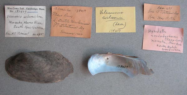
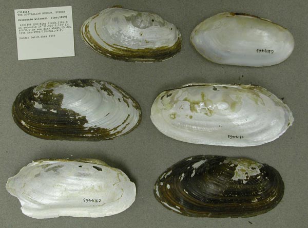
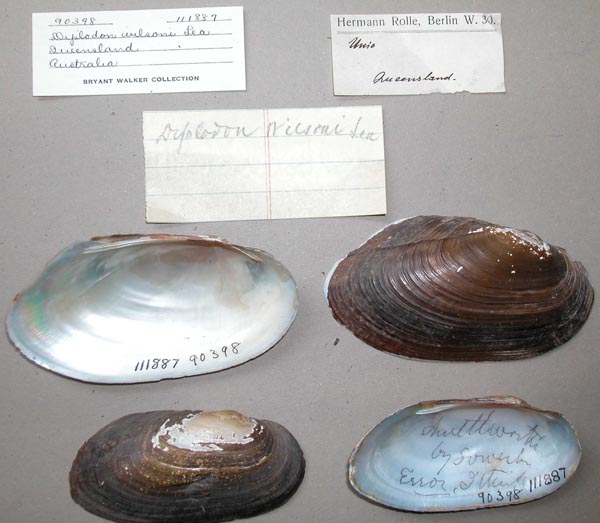
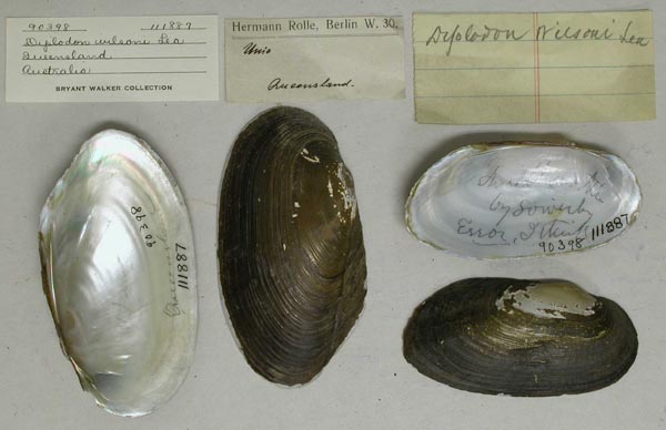
Bivalvia | Unionida | Hyrioidea | Hyriidae | Velesunioninae | Velesunio species Velesunio wilsonii (Lea, 1859): specimens
3 available nominal species synonyms (5 total synonyms) Recent Taxonomic OpinionsVelesunio wilsonii — Graf & Cummings (2007), Bogan (2010), Zieritz et al. (2013), Walker et al. (2014), Graf & Cummings (2021), Sahidin et al. (2021), Ponder et al. (2025) RangeNorthern Australia from New South Wales and Queensland west to Western Australia, and New Guinea. Map of Georeferenced Specimens
Australia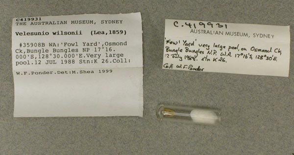
AMS_419931
'Fowl Yard', Osmond Ck, Bungle Bungles NP (Very large pool), Western Australia, Australia [-17.267, 128.5 ± 1 km]
| 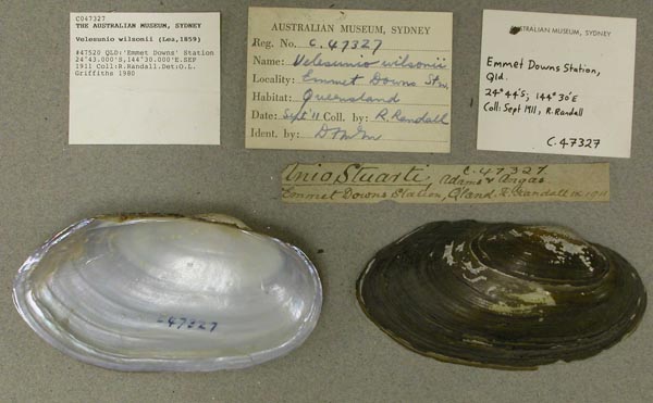
AMS_47327
"Emmet Downs" Station, Queensland, Australia [-24.717, 144.5 ± 10 km]
| 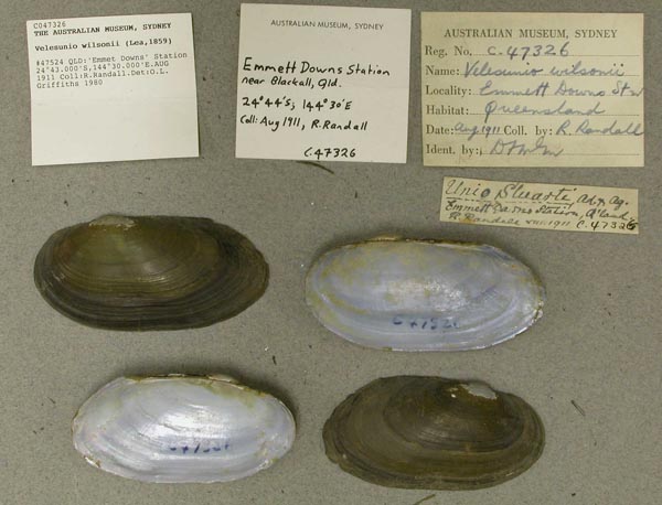
AMS_47326
"Emmet Downs" Station, Queensland, Australia [-24.721, 144.496 ± 10 km]
| 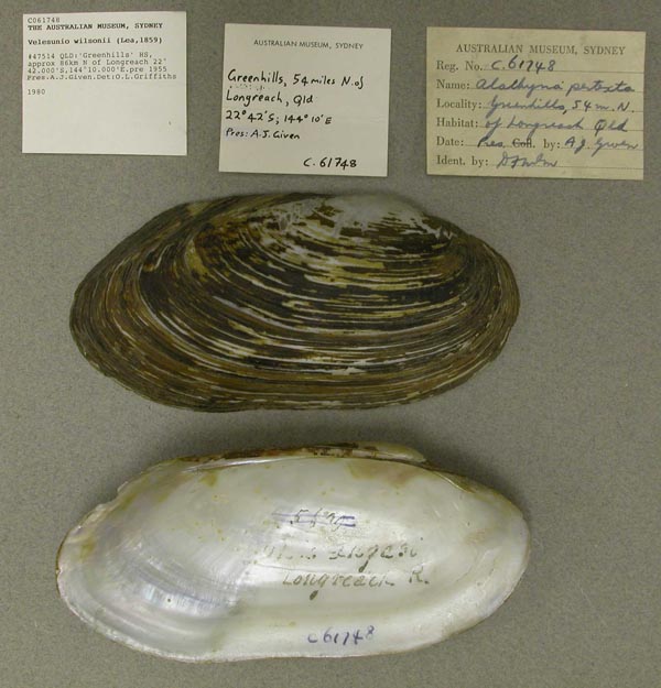
AMS_61748
"Greenhills" HS, approx 86km N of Longreach, Queensland, Australia [-22.7, 144.167 ± 10 km]
| 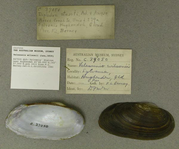
AMS_37050
"Sylvania" Station near Hughenden, Queensland, Australia [-20.8, 143.95 ± 10 km]
| 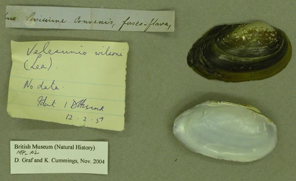
BMNH_MP_102
[no locality available - Australia]
| 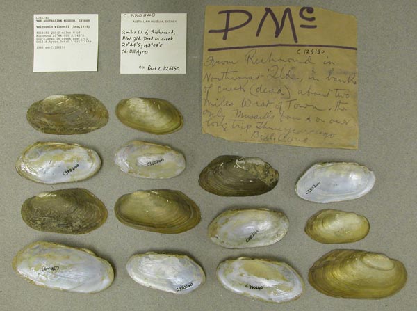
AMS_380240
2 mi W of Richmond (dead in creek), Queensland, Australia [-20.733, 143.133 > ± 100 km]
| 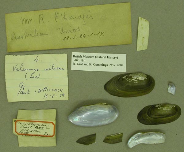
BMNH_MP_120
Abbott Bay, J.E.T.W., Qy
| 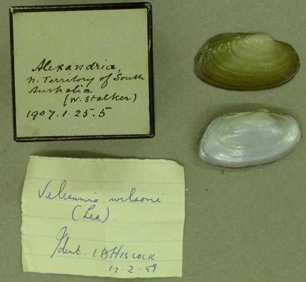
BMNH_1907-1-25-5
Alexandria, N. Territory of South Australia
| 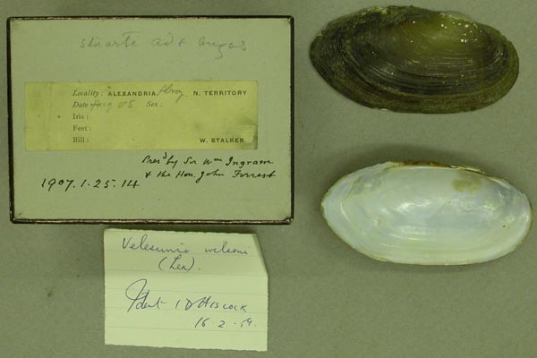
BMNH_1907-1-25-14
Alexandria, N. Territory of South Australia
| 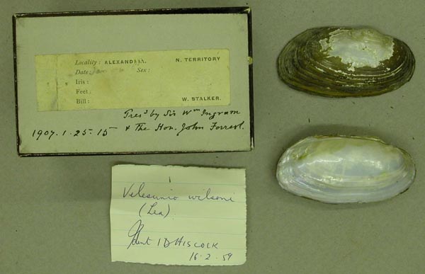
BMNH_1907-1-25-15
Alexandria, N. Territory, N Central Australia
| 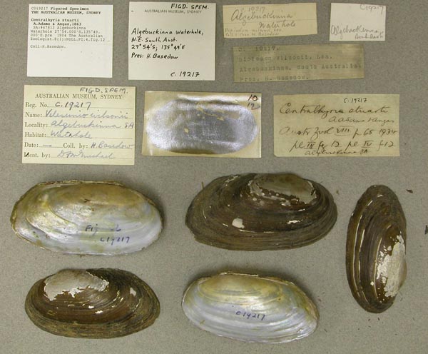
AMS_19217
Algebuckinna Waterhole, Southern Australia, Australia [-27.9, 135.817 ± 10 km]
| 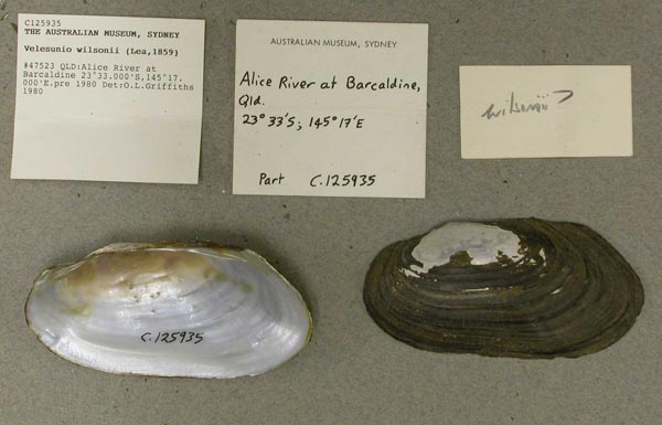
AMS_125935
Alice River at Barcaldine, Queensland, Australia [-23.55, 145.283 ± 10 km]
| 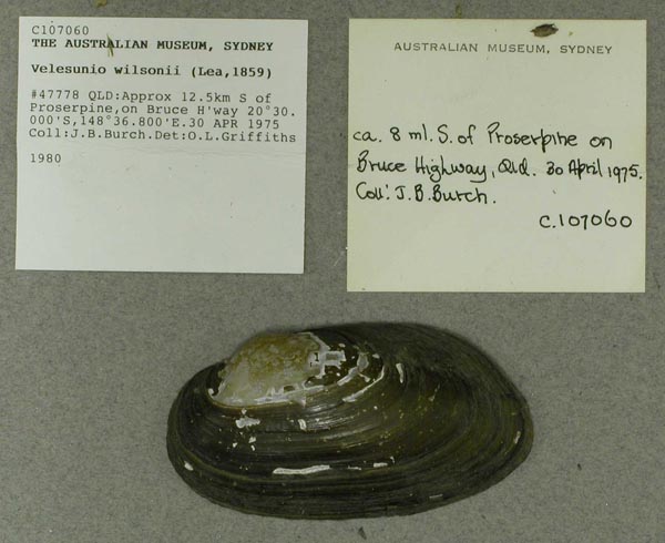
AMS_107060
Approx 12.5 km S of Proserpine, on Bruce H'way, Queensland, Australia [-20.5, 148.613 ± 10 km]
| 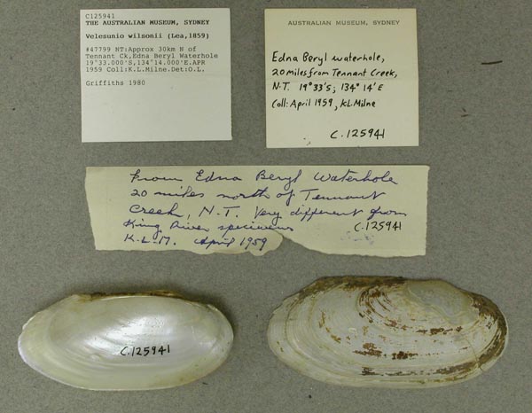
AMS_125941
Approx 30 km N of Tennant Ck, Edna Beryl Waterhole, Northern Territory, Australia [-19.55, 134.233 > ± 100 km]
| 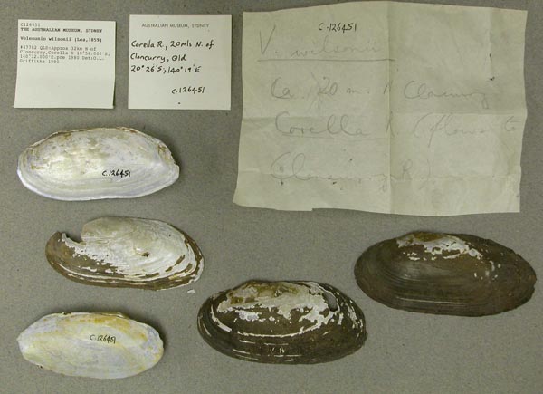
AMS_126451
Approx 32 km N of Cloncurry, Corella R, Queensland, Australia [-18.933, 140.533 ± 10 km]
| 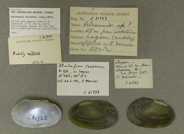
AMS_61733
Approx 40km S of Cooktown (Muddy lagoon), Queensland, Australia [-15.698, 145.14 ± 100 km]
| 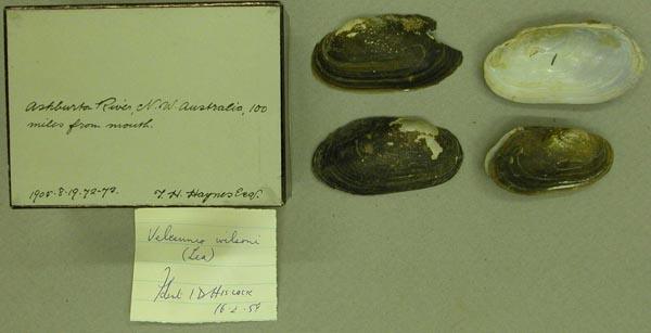
BMNH_1905-8-19-72-73
Ashburton River, NW Australia, 100 mi from mouth
| 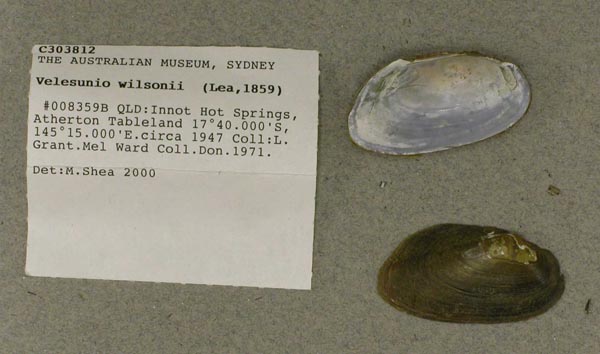
AMS_303812
Atherton Tableland, Innot Hot Springs, Queensland, Australia [-17.667, 145.25 ± 10 km]
| 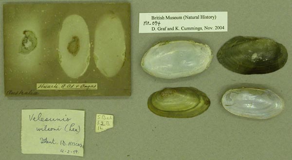
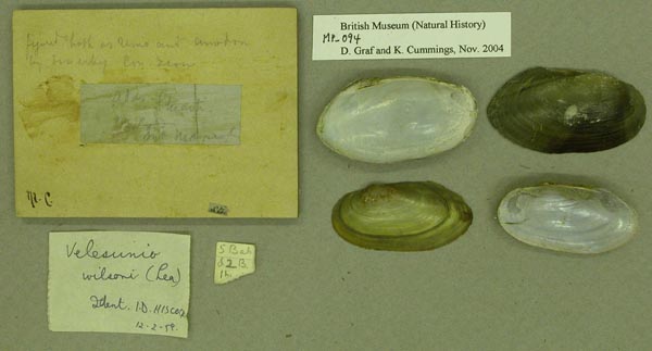
BMNH_MP_094
Australia
| 
BMNH_MP_094
Australia
| 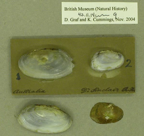
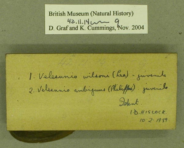
BMNH_42-11-14-9
Australia
| 
BMNH_42-11-14-9
Australia
| 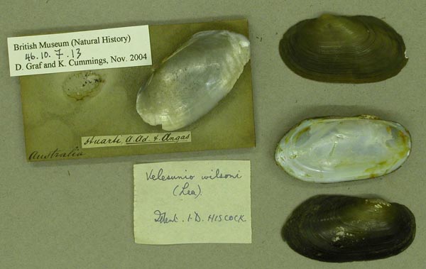
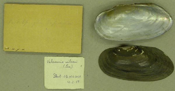
BMNH_46-10-7-13
Australia
| 
BMNH_46-10-7-11
Australia
| 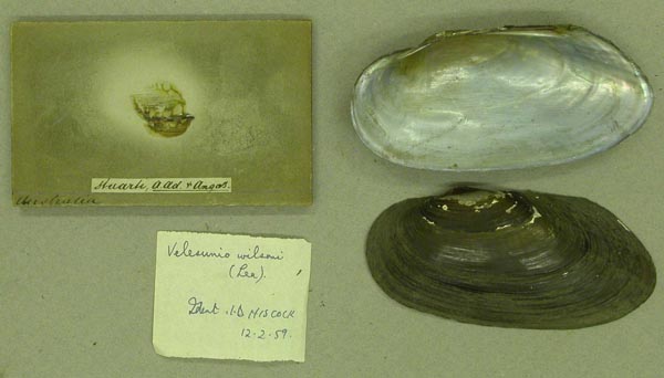
BMNH_46-10-7-11
Australia
| 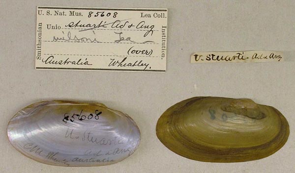
USNM_85608
Australia
| 
USNM_85608
Australia
| 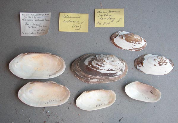
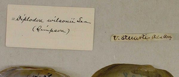
MCZ_190271
Avon Downs, Northern Territory, Australia
| 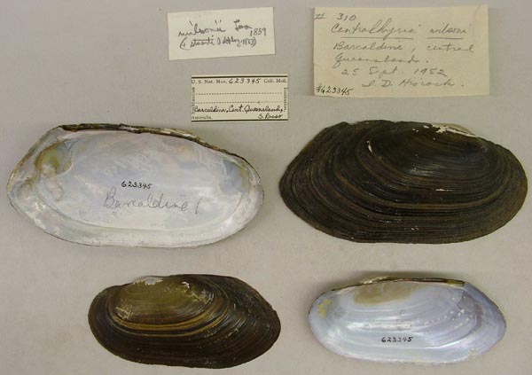
USNM_623345
Barcaldine, central Queensland, Australia
| 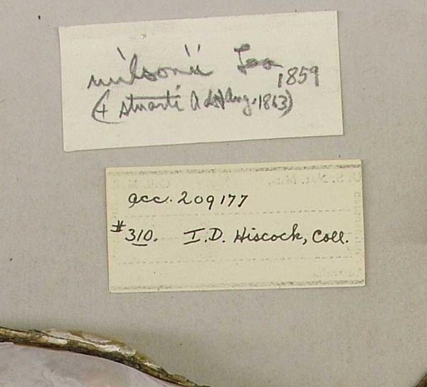
USNM_623345
Barcaldine, central Queensland, Australia
| 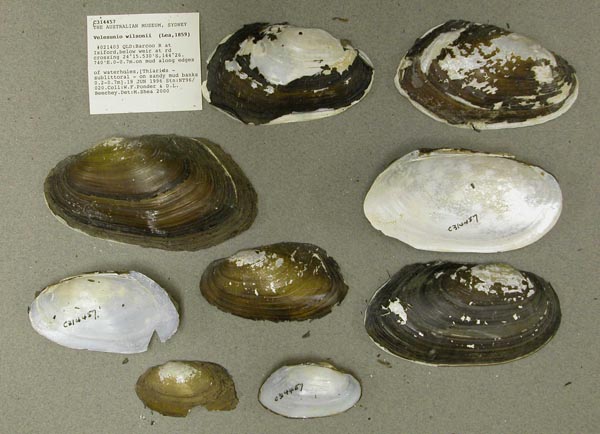
AMS_314457
Barcoo R at Isiford, below weir at rd crossing (on mud along edges of waterholes, [Thiarids - sublittoral - on sandy mud banks 0.2-0.7m]), Queensland, Australia [-24.259, 144.446 ± 100 m]
| 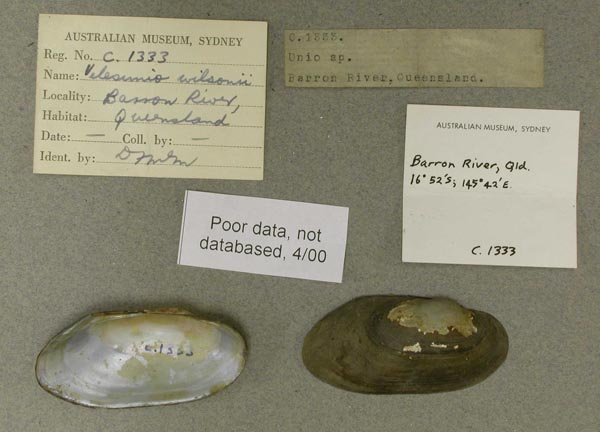
AMS_1333
Barron River, Queensland
| 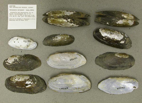
AMS_327768
Bayswater Ck on Burke Development Rd, Queensland, Australia [-17.318, 141.515 ± 1 km]
| 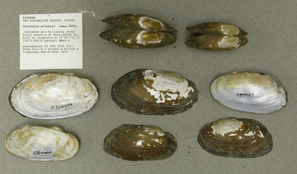
AMS_314466
Billabong above Tully Inlet, W. of Mornington Is., Gulf of Carpentaria (amongst weed & macrophytes), Queensland, Australia [-16.762, 138.149 ± 100 m]
| 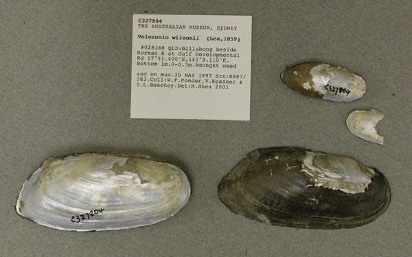
AMS_327804
Billabong beside Norman R at Gulf Developmental Rd (Amongst weed and on mud), Queensland, Australia [-17.857, 141.135 ± 100 m]
| 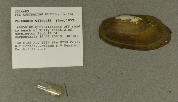
AMS_314483
Billabong off road to beach nr Tully Inlet, W. of Mornington Is, Gulf of Carpentaria, Queensland, Australia [-16.782, 138.169 ± 100 m]
| 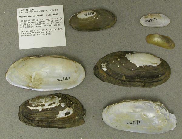
AMS_327776
Billabong on E side of Leichhardt River (on mud amongst weeds and on weeds), Queensland, Australia [-18.227, 139.898 ± 100 m]
| 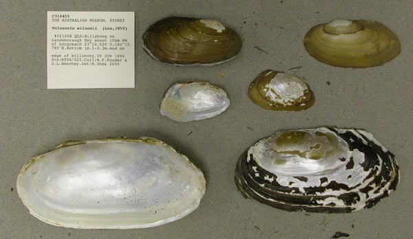
AMS_314455
Billabong on Landsborough Hwy about 10km NW of Longreach (mud on edge of billabong), Queensland, Australia [-23.4, 144.213 ± 100 m]
| 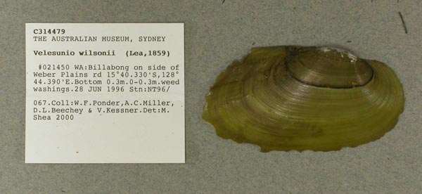
AMS_314479
Billabong on side of Weber Plains rd (weed washings), Western Australia, Australia [-15.672, 128.74 ± 100 m]
| 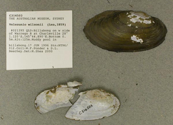
AMS_314503
Billabong on w side of Warrego R at Charleville (Muddy pool in billabong), Queensland, Australia [-28.019, 145.748 ± 100 m]
| 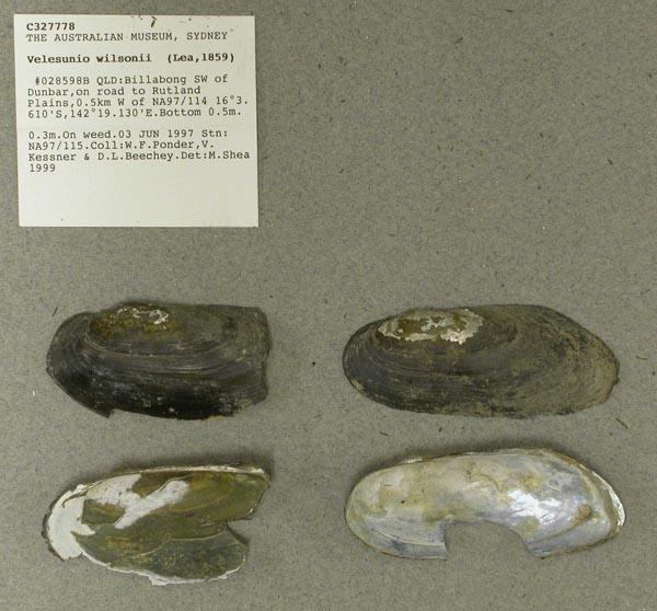
AMS_327778
Billabong SW of Dunbar, on road to Rutland Plains, 0.5km W of NA97/114 (On weed), Queensland, Australia [-16.06, 142.319 ± 100 m]
| 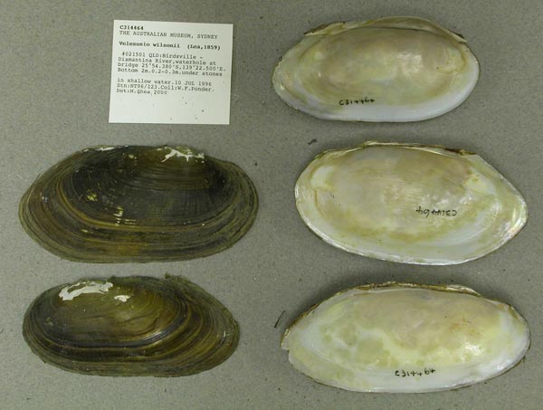
AMS_314464
Birdsville - Diamantina River, waterhole at bridge (under stones in shallow water), Queensland, Australia [-25.906, 139.375 ± 100 m]
| 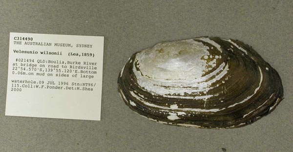
AMS_314490
Boulia, Burke River at bridge on road to Birdsville (on mud on sides of large waterhole), Queensland, Australia [-22.909, 139.919 ± 100 m]
| 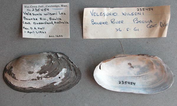
MCZ_235454
Bourke River, Boulia, central Queensland, Australia
| 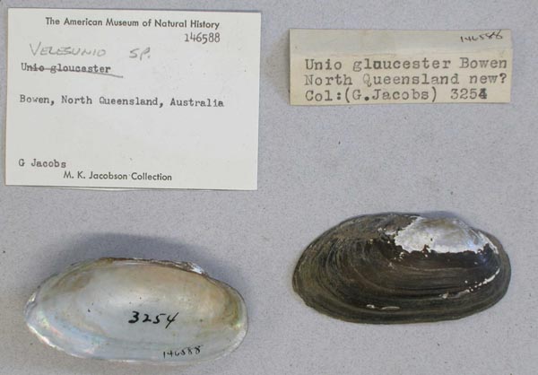
AMNH_146588
Bowen, North Queensland, Australia
| 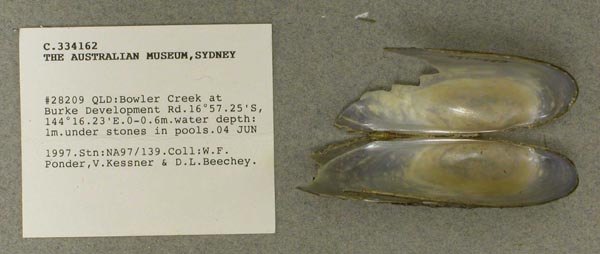
AMS_334162
Bowler Creek at Burke Development Rd (under stones in pools), Queensland, Australia [-16.954, 144.27 ± 100 m]
| 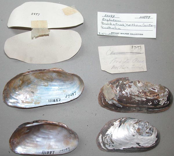
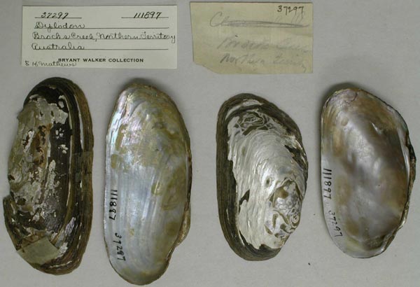
UMMZ_111897
Brocks Creek, Northern Territory, Australia
| 
UMMZ_111897
Brocks Creek, Northern Territory, Australia
| 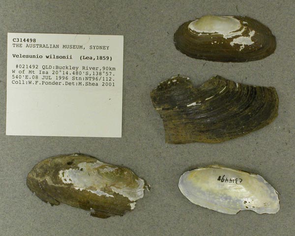
AMS_314498
Buckley River, 90km W of Mt Isa, Queensland, Australia [-20.241, 138.959 ± 100 m]
| 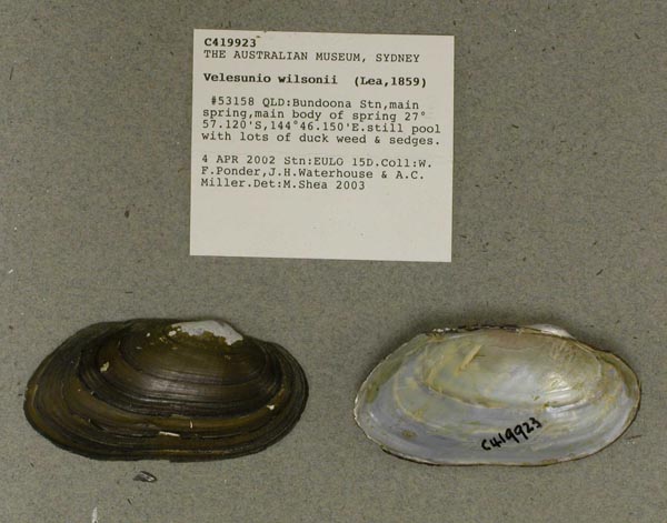
AMS_419923
Bundoona Stn, main spring, main body of spring (still pool with lots of duck weed & sedges), Queensland, Australia [-27.952, 144.769 ± 100 m]
| 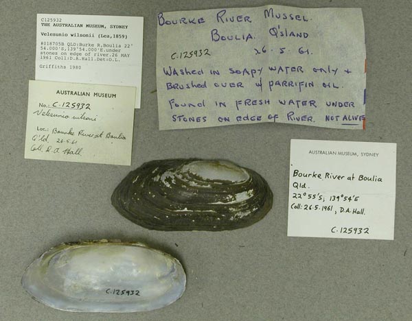
AMS_125932
Burke R, Boulia (under stones on edge of river), Queensland, Australia [-22.9, 139.9 ± 10 km]
| 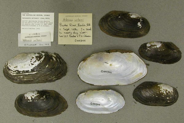
AMS_144344
Burke River at Boulia (In sand in nearly dry river), Queensland, Australia [-22.9, 139.9 ± 1 km]
| 
AMS_419927
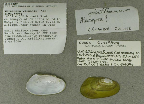
Burnett R, at causeway, W of Childers on rd to Booyal (Under stones in wide, sandy shallow river), Queensland, Australia [-25.229, 152.012 ± 1 km]
| 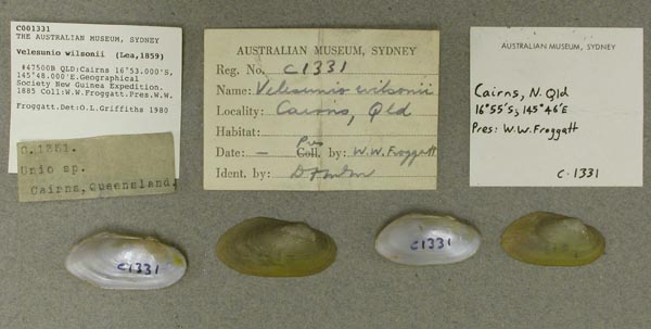
AMS_1331
Cairns, Queensland, Australia [-16.883, 145.8 ± 10 km]
| 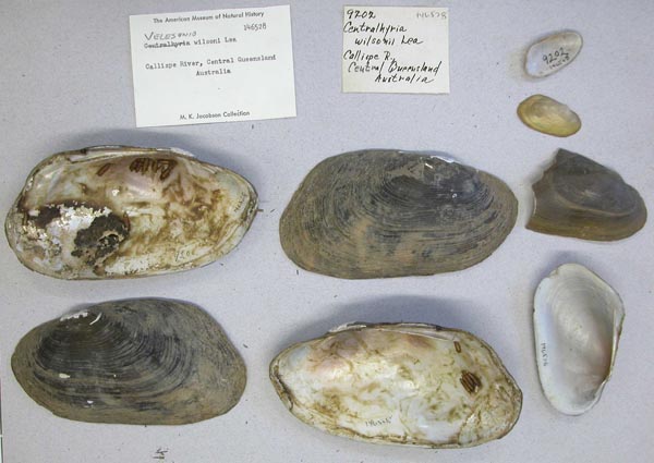
AMNH_146528
Calliope River, Queensland, Australia
| 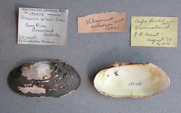
MCZ_190270
Cape River, Queensland, Australia
| 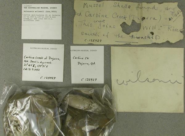
AMS_125927
Carbine Ck at Dajarra (Dry creek), Queensland, Australia [-21.7, 139.517 ± 10 km]
| 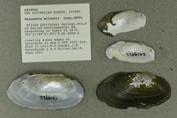
AMS_419922
Carpet Springs Stn, S of Bulloo Developmental Rd, waterholes in Yowah Ck (On wood & crawling along edges of waterhole in mud.), Queensland, Australia [-28.139, 144.864 ± 100 m]
| 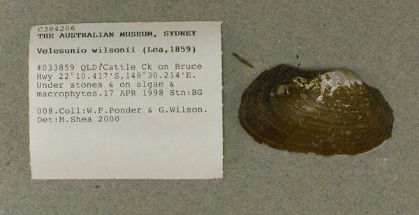
AMS_384206
Cattle Ck on Bruce Hwy (Under stones & on algae & macrophytes), Queensland, Australia [-22.174, 149.504 ± 100 m]
| 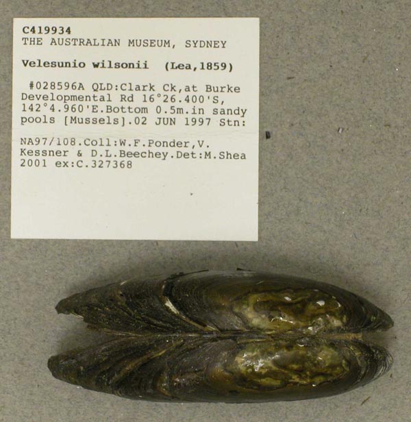
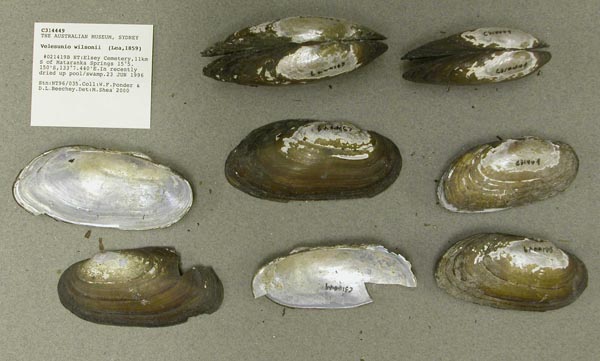
AMS_419934
Clark Ck, at Burke Developmental Rd (in sandy pools [Mussels]), Queensland, Australia [-16.44, 142.083 ± 100 m]
| 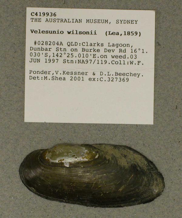
AMS_419936
Clarks Lagoon, Dunbar Stn on Burke Dev Rd (on weed), Queensland, Australia [-16.017, 142.417 ± 100 m]
| 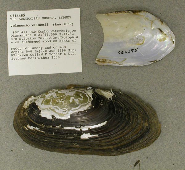
AMS_314485
Combo Waterhole on Diamantina R ([Notopala - on submerged wood on banks of muddy billabong and on mud depths 0-0.3m]), Queensland, Australia [-21.6, 142.064 ± 100 m]
| 
BMNH_1907-1-25-4
Corella Lake, Alexandria, N. Territory of South Australia
| 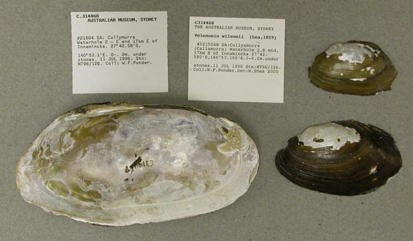
AMS_314468
Cullyamurra (Callamurra) Waterhole 2, E end, 17km E of Innamincka (under stones), Southern Australia, Australia [-27.71, 140.885 ± 100 m]
| 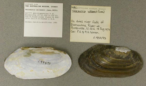
AMS_95493
Diamantina R at Birdsville (Dried river flats), Queensland, Australia [-25.417, 139.392 ± 10 km]
| 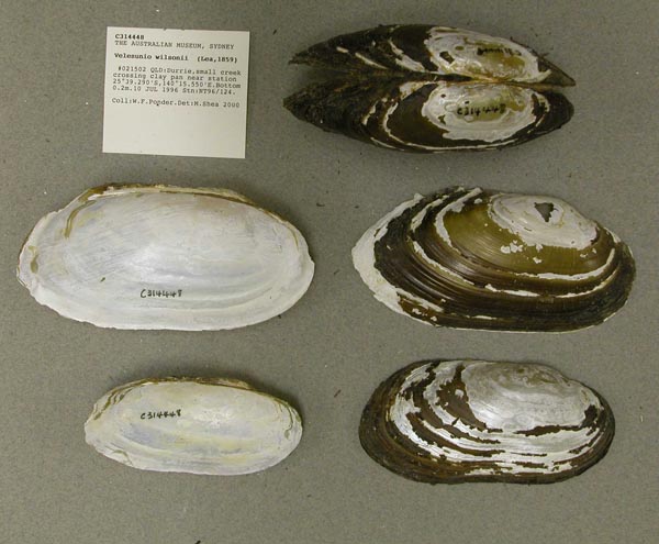
AMS_314448
Durrie, small creek crossing clay pan near station, Queensland, Australia [-25.655, 140.259 ± 100 m]
| 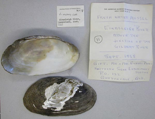
AMNH_96039
Einasleigh River, above the junction of the Gilbert River, Queensland, Australia
| 
AMS_314449
Elsey Cemetery, 11km S of Mataranka Springs (In recently dried up pool/swamp), Northern Territory, Australia [-15.086, 133.124 ± 100 m]
| 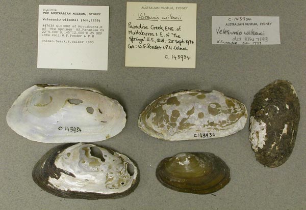
AMS_143934
ENE of Muttaburra, E of "The Springs" HS, Paradise Ck, Queensland, Australia [-22.15, 145.2 ± 10 km]
| 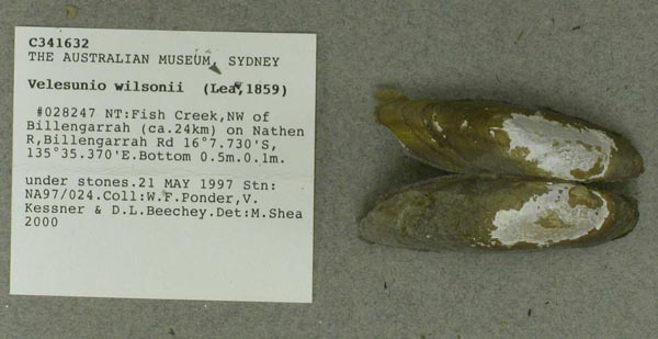
AMS_341632
Fish Creek, NW of Billengarrah (ca. 24km) on Nathen R, Billengarrah Rd (under stones), Northern Territory, Australia [-16.129, 135.589 ± 100 m]
| 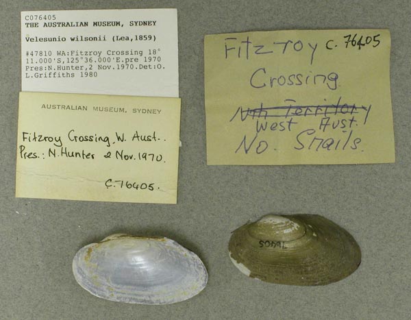
AMS_76405
Fitzroy Crossing, Western Australia, Australia [-18.183, 125.6 ± 10 km]
| 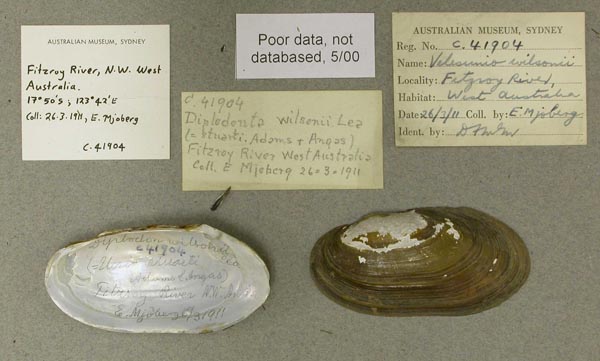
AMS_41904
Fitzroy River, N.W. West Australia; 17°50’S, 123°42’E
| 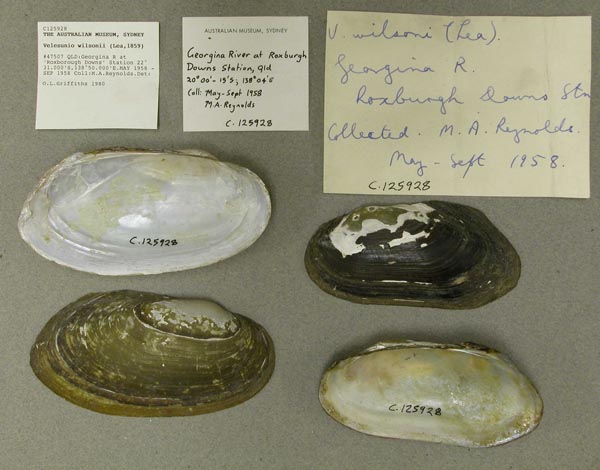
AMS_125928
Georgina R at "Roxborough Downs" Station, Queensland, Australia [-22.517, 138.833 ± 10 km]
| 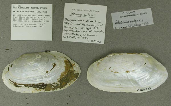
AMS_145013
Georgina River, 45km E of Glenormiston HS, W of Boulia (dry creekbed, one of channels), Queensland, Australia [-23, 139.167 ± 1 km]
| 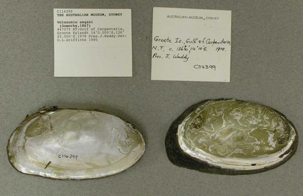
AMS_114399
Gulf of Carpentaria, Groote Eylandt, Northern Territory, Australia [-14, 136.417 ± 100 km]
| 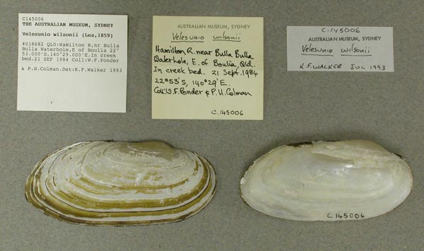
AMS_145006
Hamilton R, nr Bulla Bulla Waterhole, E of Boulia (In creek bed), Queensland, Australia [-22.883, 140.483 ± 1 km]
| 
BMNH_85-6-12-85-86
Isaac and Burnett rivers, Queensland
| 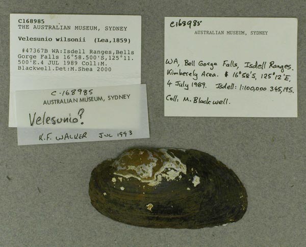
AMS_168985
Isdell Ranges, Bells Gorge Falls, Western Australia, Australia [-16.975, 125.192 ± 1 km]
| 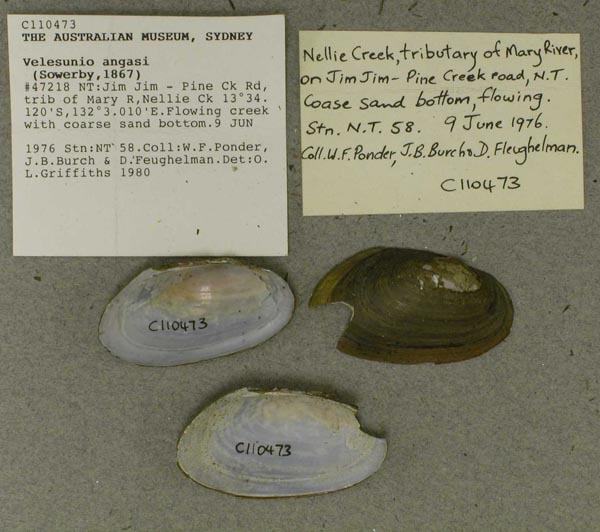
AMS_110473
Jim Jim - Pine Ck Rd, trib of Mary R, Nellie Ck (Flowing creek with coarse sand bottom), Northern Territory, Australia [-13.569, 132.05 ± 1 km]
| 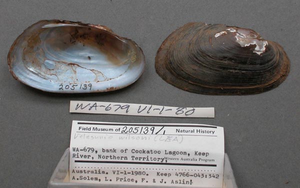
FMNH_205139
Keep River, bank of Cockatoo Lagoon, Northern Territory, Western Australia
| 
AMS_314463
King Creek, 21km S of Bedourie (see data sheet), Queensland, Australia [-24.532, 139.565 ± 100 m]
| 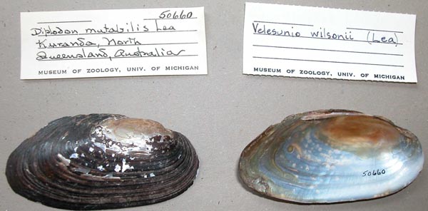
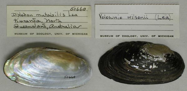
UMMZ_50660
Kuranda, North Queensland, Australia
| 
UMMZ_50660
Kuranda, North Queensland, Australia
| 
BMNH_1870-10-26-40
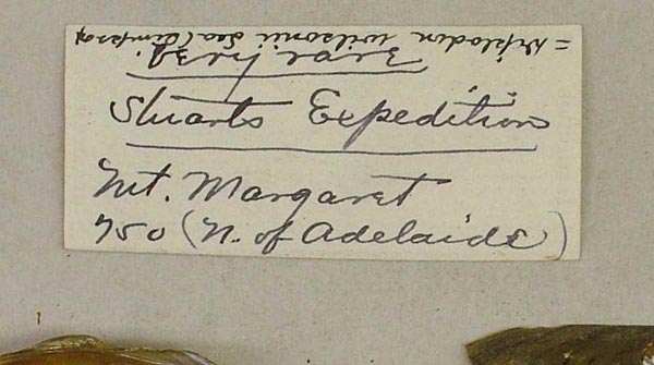
Lagoon near Mt. Margaret, Central Australia
| 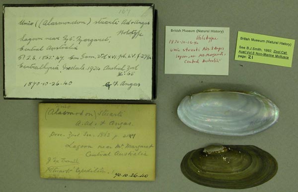
BMNH_1870-10-26-40
Lagoon near Mt. Margaret, Central Australia
| 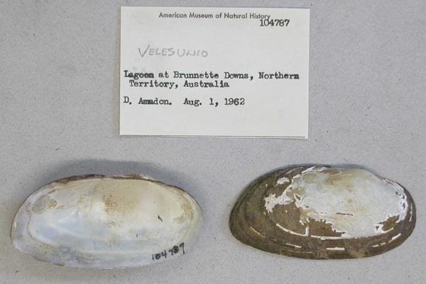
AMNH_104787
lagoon, Brunette Downs, Northern Territory, Australia
| 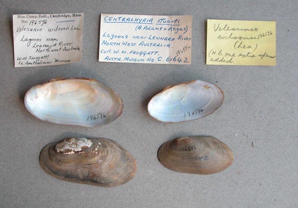
MCZ_196596
lagoons near Lennard River, Northwest Australia
| 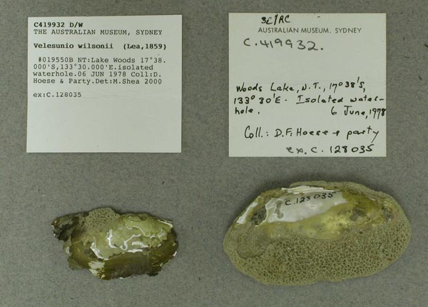
AMS_419932
Lake Woods (isolated waterhole), Northern Territory, Australia [-17.633, 133.5 ± 1 km]
| 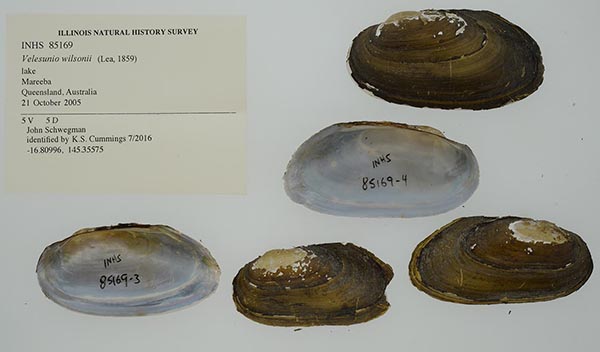
INHS_85169
lake, Mareeba, Queensland, Australia
| 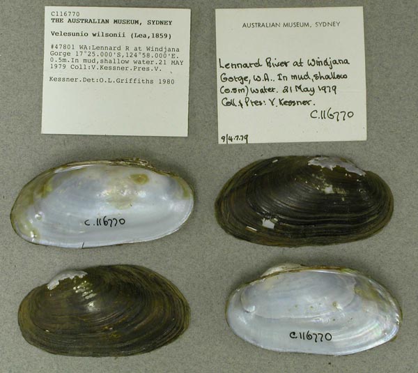
AMS_116770
Lennard R at Windjana Gorge (In mud, shallow water), Western Australia, Australia [-17.417, 124.967 ± 10 km]
| 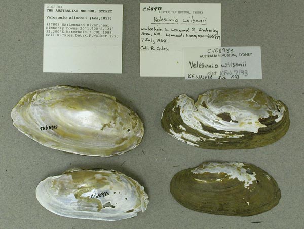
AMS_168983
Lennard River, near Kimberly Downs (Waterhole), Western Australia, Australia [-20.028, 124.538 ± 1 km]
| 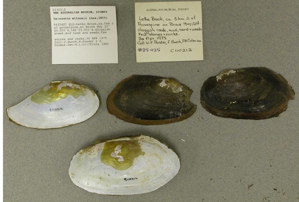
AMS_110212
Lethe Brook, ca. 5km S of Proserpine, on Bruce Hwy (Sluggish creek, mud sand, weeds, & a few stones), Queensland, Australia [-20.433, 148.583 ± 1 km]
| 
AMS_114693
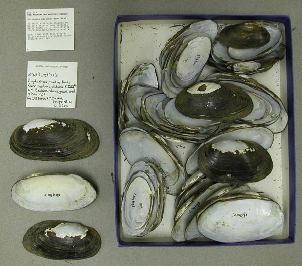
Lloyds Ck, road to Bullo R Station, near Victoria River mouth (Boulders, stones, gravel & mud), Northern Territory, Australia [-15.208, 129.633 ± 10 km]
| 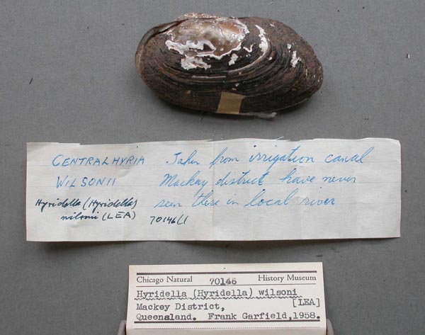
FMNH_70146
Mackey District, Queensland
| 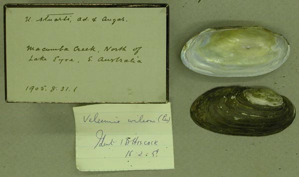
BMNH_1905-8-31-1
Macumba Creek, North of Lake Eyre, S. Australia
| 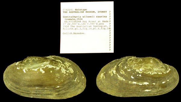
AMS_42241
May River at Meda, Western Australia, Australia [-17.367, 124 ± 10 km]
| 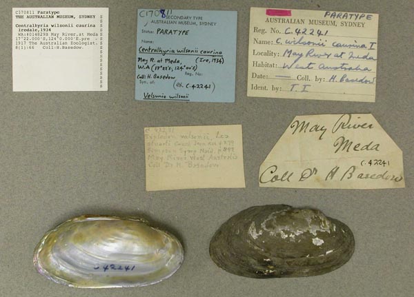
AMS_170811
May River, at Meda, Western Australia, Australia [-17.367, 124 ± 10 km]
| 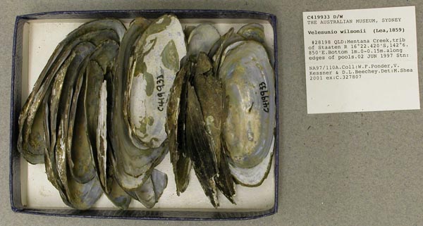
AMS_419933
Mentana Creek, trib of Staaten R (along edges of pools), Queensland, Australia [-16.374, 142.114 ± 100 m]
| 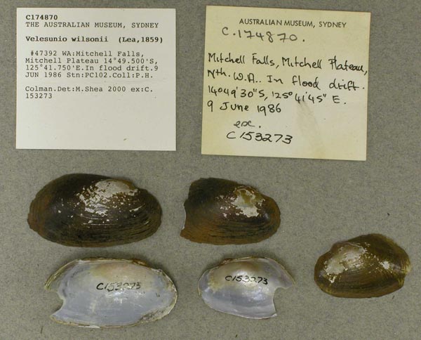
AMS_174870
Mitchell Falls, Mitchell Plateau (In flood drift), Western Australia, Australia [-14.825, 125.696 ± 1 km]
| 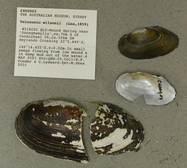
AMS_400903
Mound Spring near "Doongmabulla", ca. 7km S of Carmichael Ck, ca. 50km SW Beylando Crossing (In small seeps flowing from low mound & in damp mud out of the water.), Queensland, Australia [-22.091, 146.24 ± 100 m]
| 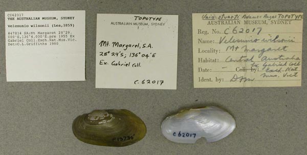
AMS_62017
Mt Margaret, Southern Australia, Australia [-28.483, 136.067 ± 10 km]
| 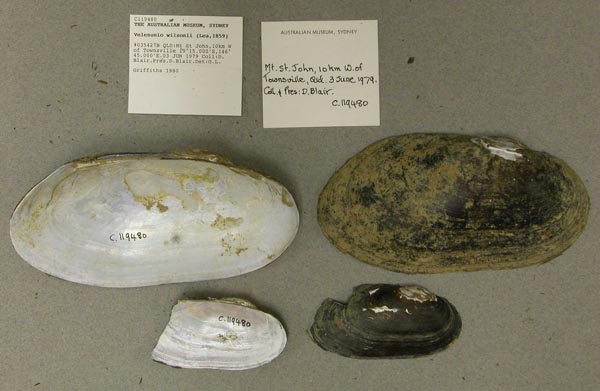
AMS_119480
Mt St John, 10km W of Townsville, Queensland, Australia [-19.25, 146.75 ± 10 km]
| 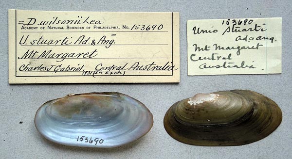
ANSP_153690
Mt. Margaret, Central Australia
| 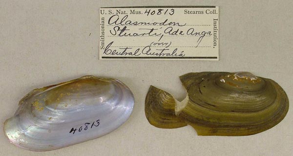
USNM_40813
Mt. Margaret, N of Adelaide, Central Australia
| 
USNM_40813
Mt. Margaret, N of Adelaide, Central Australia
| 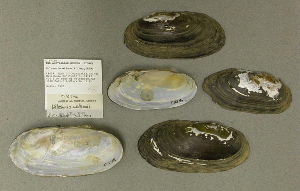
AMS_167196
N of Oodnadatta, Eringa Waterhole (On edge of waterhole), Southern Australia, Australia [-26.283, 134.717 ± 1 km]
| 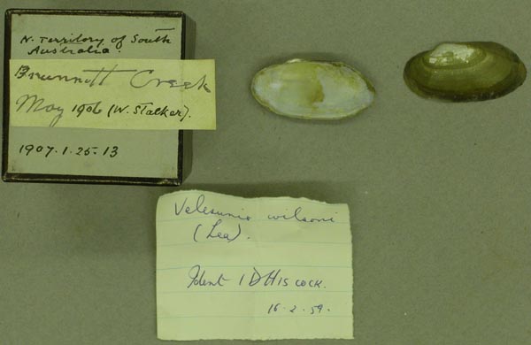
BMNH_1907-1-25-13
N. Territory of South Australia
| 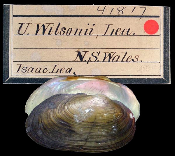
ANSP_41817
N.S. Wales
| 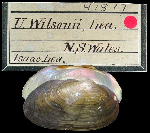
ANSP_41817
N.S. Wales
| 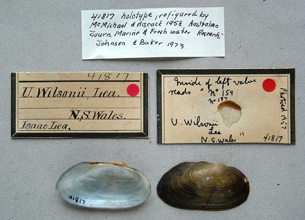
ANSP_41817
N.S. Wales
| 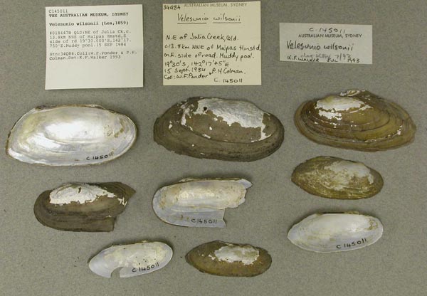
AMS_145011
NE of Julia Ck, c. 13.8km NNE of Malpas Hmstd, E side of rd (Muddy pool), Queensland, Australia [-19.5, 142.296 ± 1 km]
| 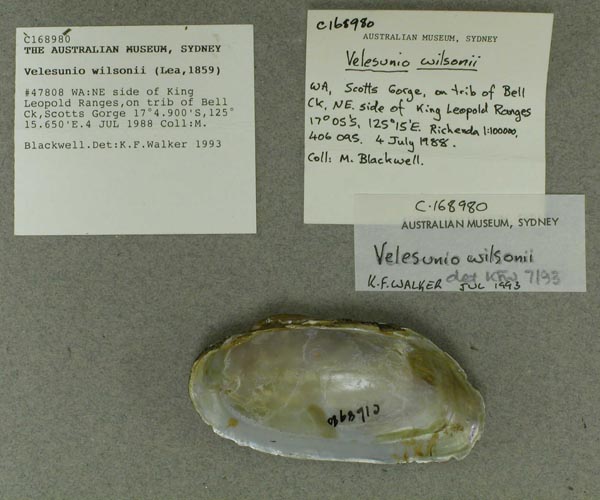
AMS_168980
NE side of King Leopold Ranges, on trib of Bell Ck, Scotts Gorge, Western Australia, Australia [-17.082, 125.261 ± 1 km]
| 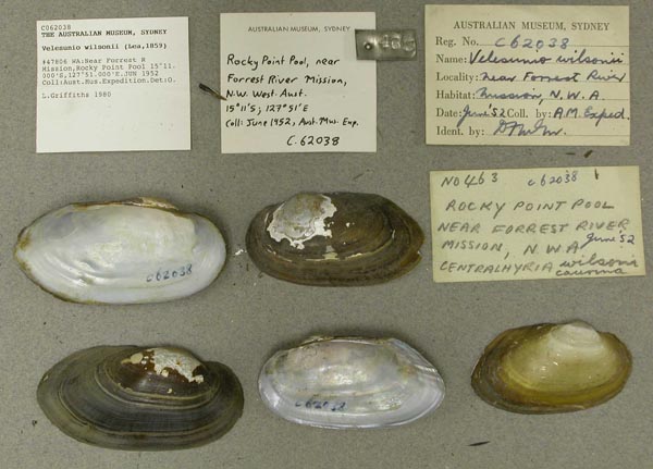
AMS_62038
Near Forrest River Mission, Rocky Point Pool, Western Australia, Australia [-15.183, 127.85 ± 10 km]
| 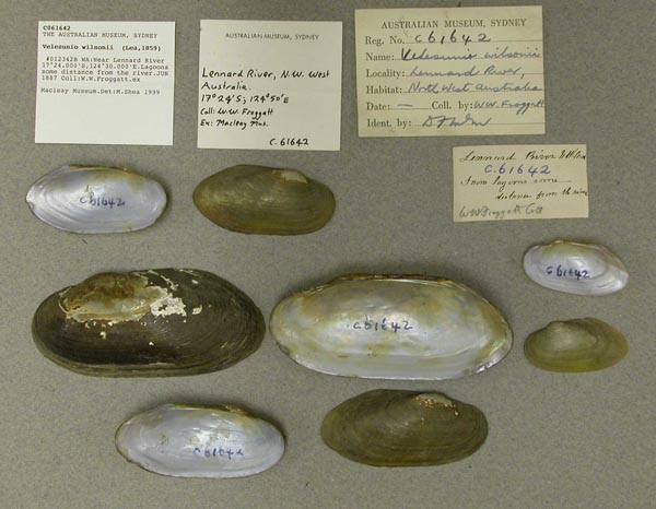
AMS_61642
Near Lennard River (Lagoons some distance from the river), Western Australia, Australia [-17.4, 124.5 > ± 100 km]
| 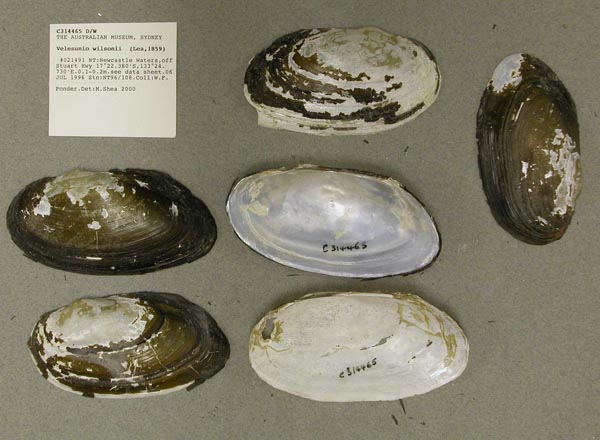
AMS_314465
Newcastle Waters, off Stuart Hwy (see data sheet), Northern Territory, Australia [-17.373, 133.412 ± 100 m]
| 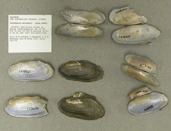
AMS_419935
Nolan Creek at Burke Developmental Rd, Queensland, Australia [-16.811, 144.168 ± 100 m]
| 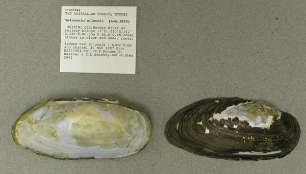
AMS_327766
Norman River at railway bridge (under stones in river and under roots, ledges etc. in pools - slow flow and channel), Queensland, Australia [-17.854, 141.139 ± 100 m]
| 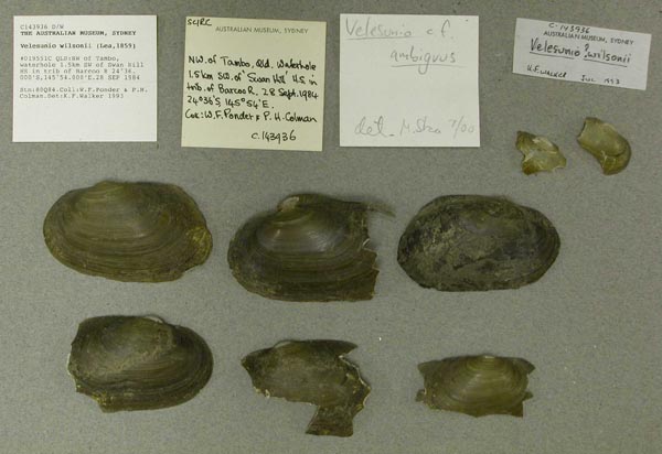
AMS_143936
NW of Tambo, waterhole 1.5km SW of Swan Hill HS in trib of Barcoo R, Queensland, Australia [-24.6, 145.9 ± 10 km]
| 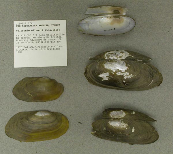
AMS_110218
off Nebo-Collinsville Rd, approx 1km along Mt Britton-Homevale Rd, Queensland, Australia [-21.508, 148.547 ± 10 km]
| 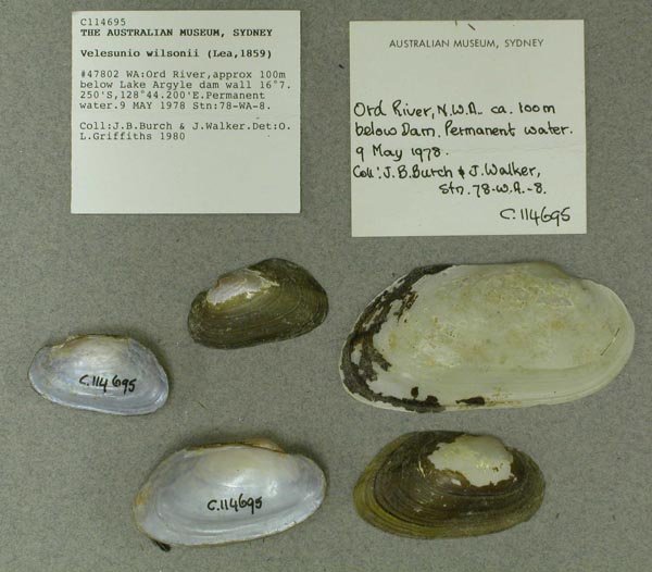
AMS_114695
Ord River, approx 100m below Lake Argyle dam wall (Permanent water), Western Australia, Australia [-16.121, 128.737 ± 100 m]
| 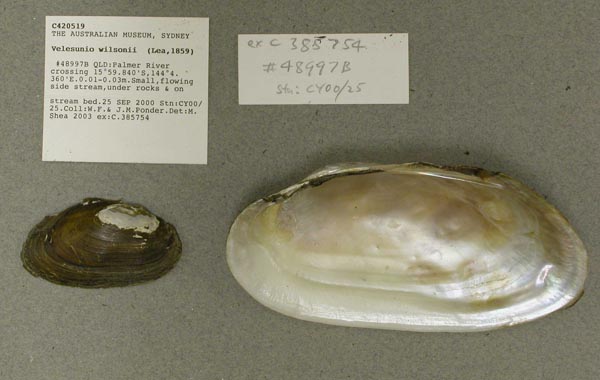
AMS_420519
Palmer River crossing (Small, flowing side stream, under rocks & on stream bed), Queensland, Australia [-15.997, 144.073 ± 100 m]
| 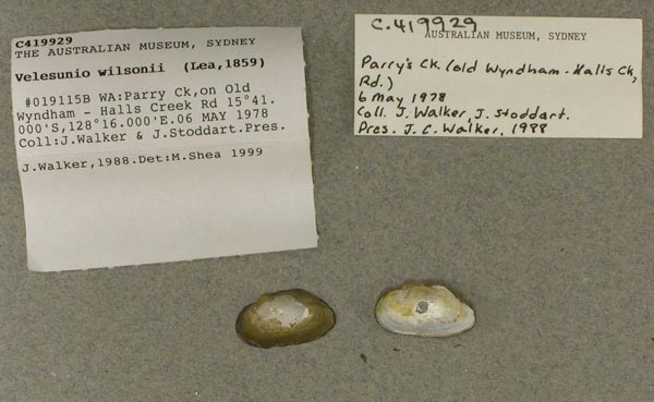
AMS_419929
Parry Ck, on Old Wyndham - Halls Creek Rd, Western Australia, Australia [-15.683, 128.267 ± 1 km]
| 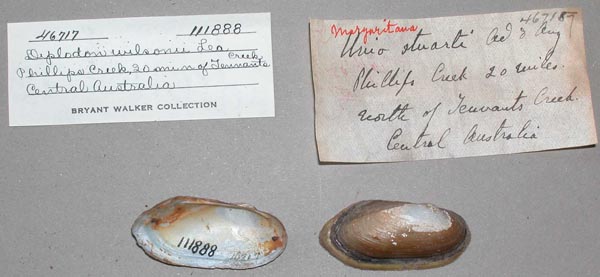
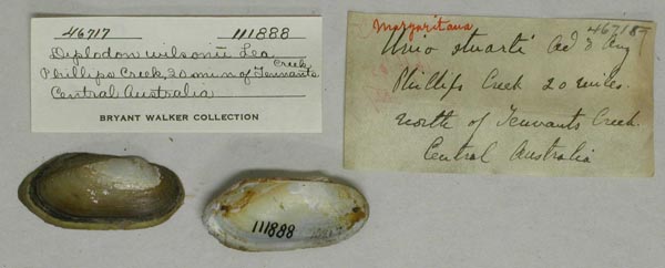
UMMZ_111888
Phillips Creek, 20 mi N Tennants Creek, Central Australia
| 
UMMZ_111888
Phillips Creek, 20 mi N Tennants Creek, Central Australia
| 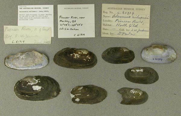
AMS_61719
Pioneer River, near Mackay, Queensland, Australia [-21.133, 148.917 ± 100 km]
| 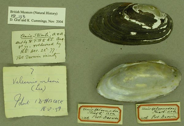
BMNH_MP_133
Port Darwin
| 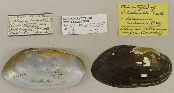
USNM_215556
Port Darwin, Bednall, Australia
| 
USNM_215556
Port Darwin, Bednall, Australia
| 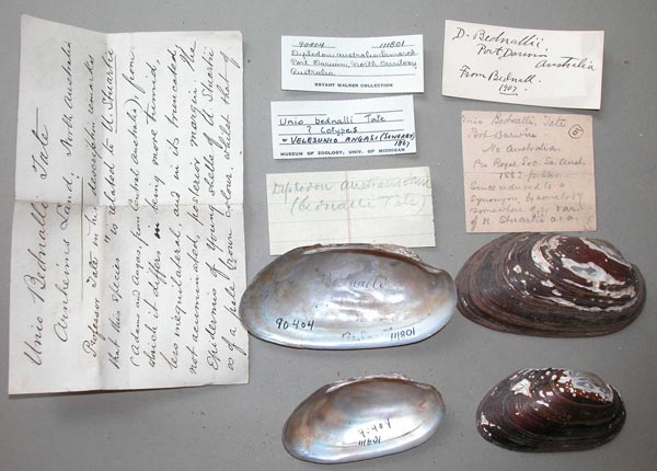
UMMZ_111801
Port Darwin, Northern Territory, Australia
| 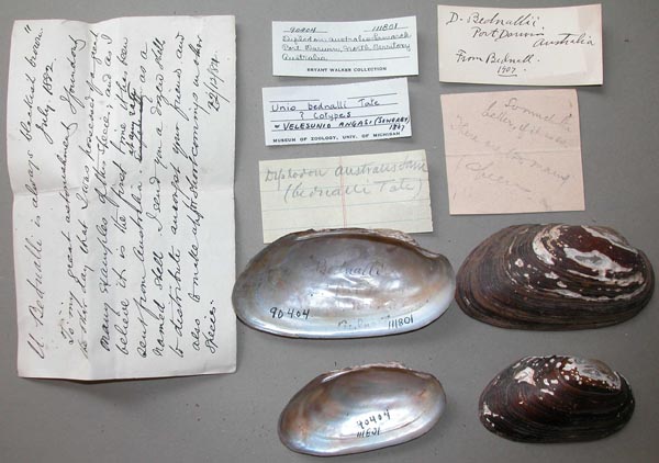
UMMZ_111801
Port Darwin, Northern Territory, Australia
| 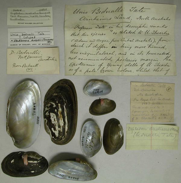
UMMZ_111801
Port Darwin, Northern Territory, Australia
| 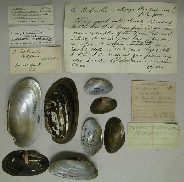
UMMZ_111801
Port Darwin, Northern Territory, Australia
| 
UMMZ_111887
Queensland, Australia
| 
UMMZ_111887
Queensland, Australia
| 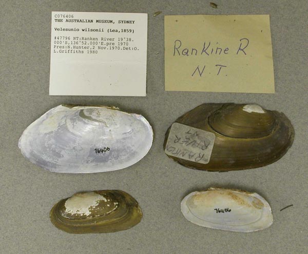
AMS_76406
Ranken River, Northern Territory, Australia [-19.633, 136.867 ± 100 km]
| 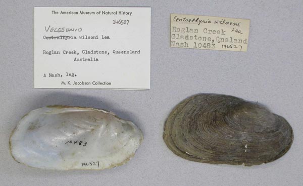
AMNH_146527
Roglan Creek, Gladstone, Queensland, Australia
| 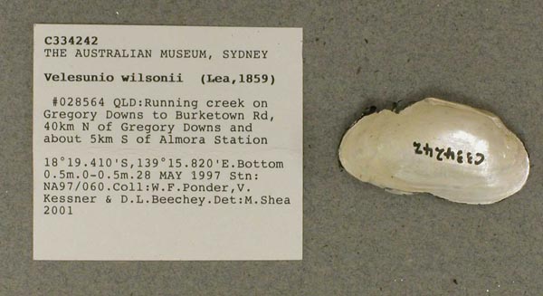
AMS_334242
Running creek on Gregory Downs to Burketown Rd, 40km N of Gregory Downs and about 5km S of Almora Station, Queensland, Australia [-18.323, 139.264 ± 100 m]
| 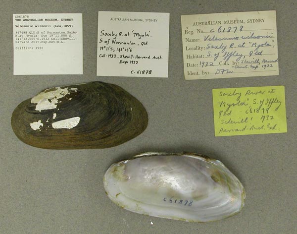
AMS_61878
S of Normanton, Saxby R, at "Myola" Stn, Queensland, Australia [-19.183, 141.2 ± 10 km]
| 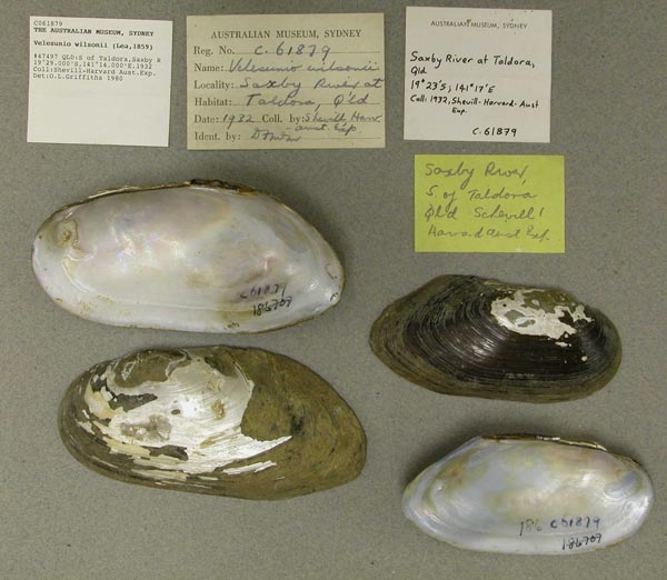
AMS_61879
S of Taldora, Saxby R, Queensland, Australia [-19.483, 141.233 ± 10 km]
| 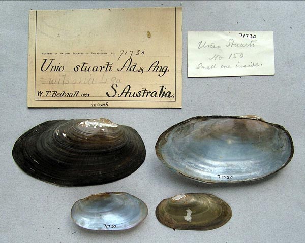
ANSP_71730
S. Australia
| 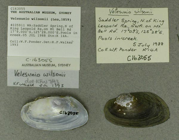
AMS_163055
Saddler Spring, N of King Leopold Ra, on Mt Bell Rd (Pools in creek), Western Australia, Australia [-17.15, 125.467 ± 1 km]
| 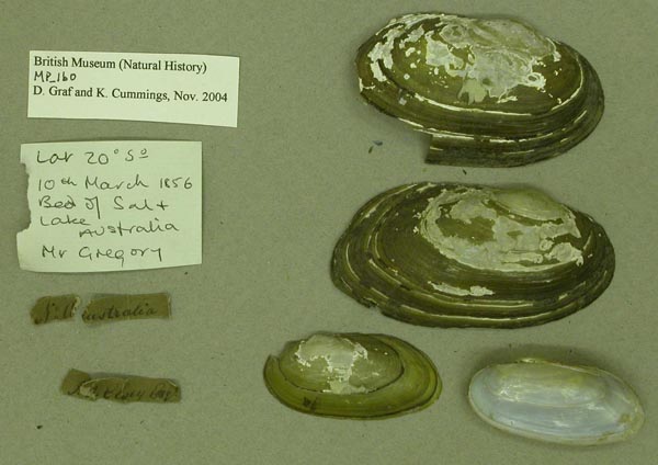
BMNH_MP_160
Salt Lake, Lat 20° 5°; Australia
| 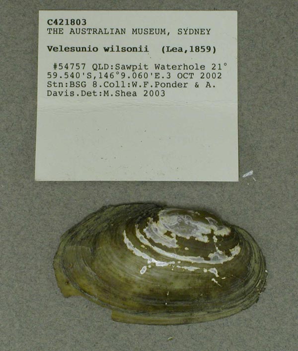
AMS_421803
Sawpit Waterhole, Queensland, Australia [-21.992, 146.151 ± 100 m]
| 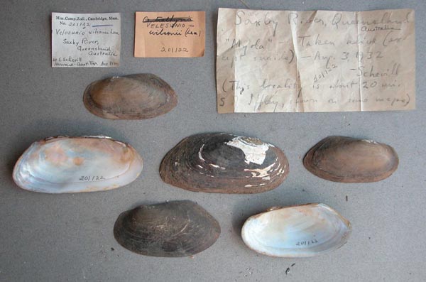
MCZ_201122
Saxby River, Queensland, Australia
| 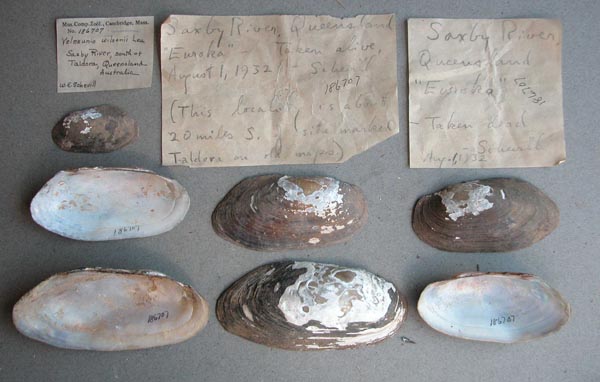
MCZ_186707
Saxby River, south of Taldora, Queensland, Australia
| 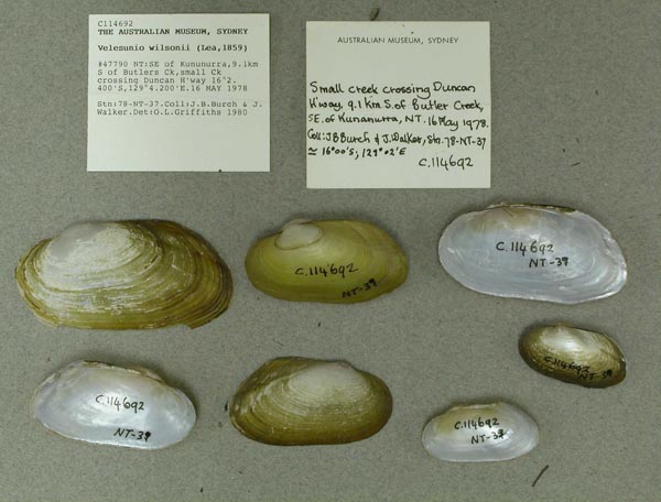
AMS_114692
SE of Kununurra, 9.1km S of Butlers Ck, small Ck crossing Duncan H'way, Northern Territory, Australia [-16.04, 129.07 ± 10 km]
| 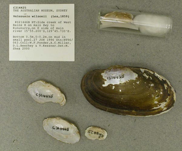
AMS_314425
Side creek of West Bains R on main Hwy to Kununurra, on E side of main river (on mud in small pool), Northern Territory, Australia [-15.92, 129.762 ± 100 m]
| 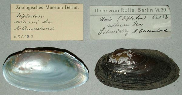
ZMB_62113
Silver Valley, N. Queensland
| 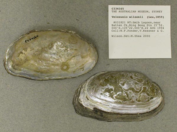
AMS_334165
Smib Lagoon, near Batten Ck, Bing Bong Stn, Northern Territory, Australia [-15.867, 135.367 ± 10 km]
| 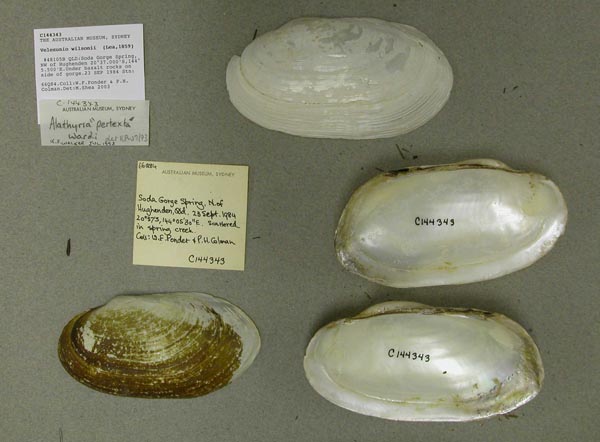
AMS_144343
Soda Gorge Spring, NW of Hughenden (Under basalt rocks on side of gorge), Queensland, Australia [-20.617, 144.092 ± 1 km]
| 
UMMZ_111889
South Australia
| 
UMMZ_111889
South Australia
| 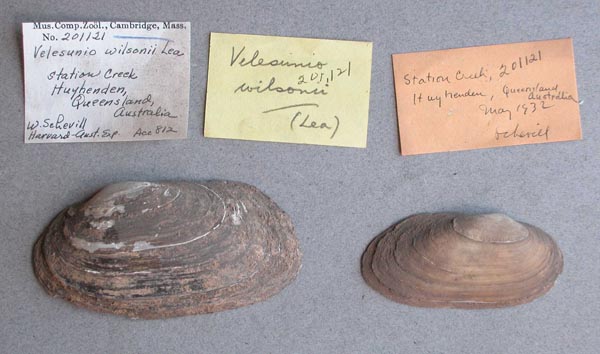
MCZ_201121
Station Creek, Huyhenden, Queensland, Australia
| 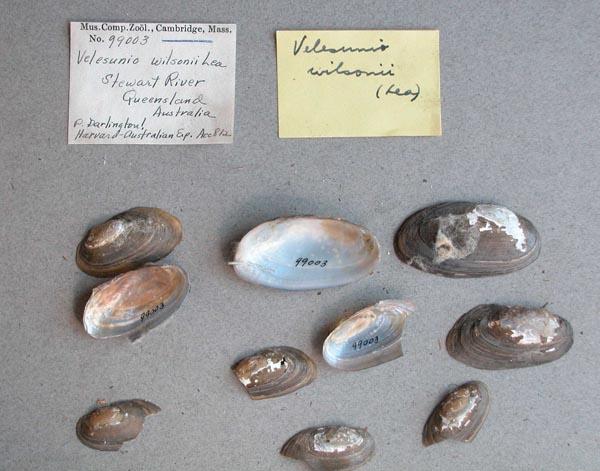
MCZ_99003
Stewart River, Queensland, Australia
| 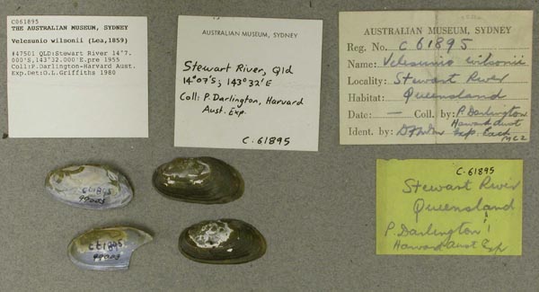
AMS_61895
Stewart River, Queensland, Australia [-14.117, 143.533 ± 100 km]
| 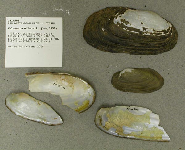
AMS_314504
Sulieman Ck, ca. 108km N of Boulia, Queensland, Australia [-22.019, 139.59 ± 100 m]
| 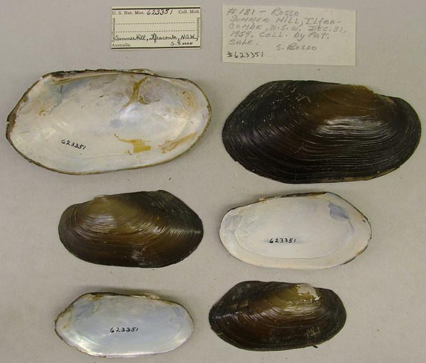
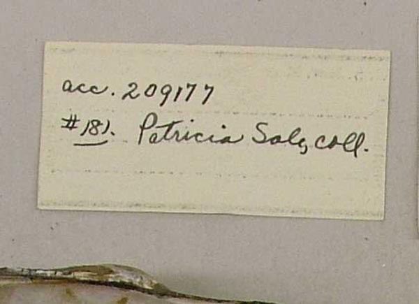
USNM_623351
Summers Hill, Ilfracombe, New South Wales, Australia
| 
USNM_623351
Summers Hill, Ilfracombe, New South Wales, Australia
| 
AMS_144341
SW of Boulia, Wongitta Waterhole (Shallow pool with fine sand & mud), Queensland, Australia [-23.75, 138.642 ± 1 km]
| 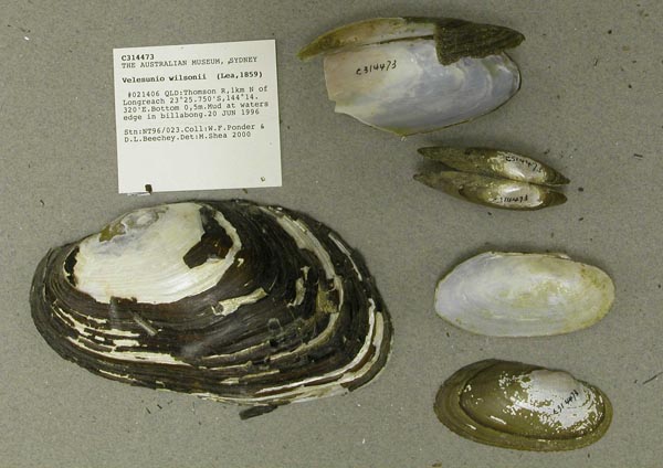
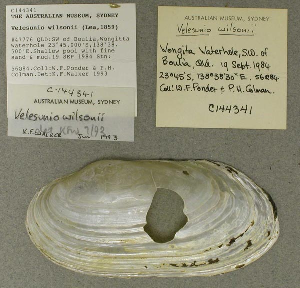
AMS_314473
Thomson R, 1km N of Longreach (Mud at waters edge in billabong), Queensland, Australia [-23.429, 144.239 ± 100 m]
| 
AMS_314453
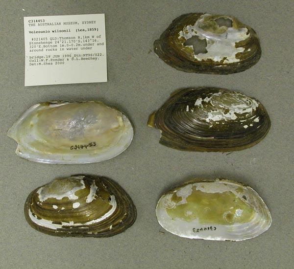
Thomson R, 1km W of Stonehenge (under and around rocks in water under bridge), Queensland, Australia [-24.353, 143.272 ± 100 m]
| 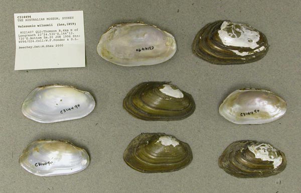
AMS_314494
Thomson R, 4km N of Longreach, Queensland, Australia [-23.409, 144.229 ± 100 m]
| 
AMS_125931
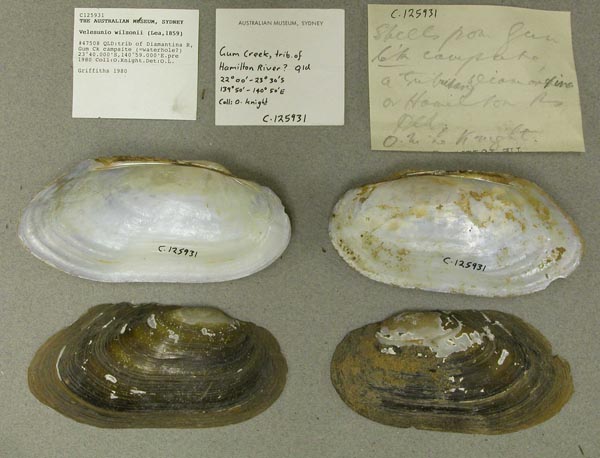
trib of Diamantina R, Gum Ck campsite (=waterhole?), Queensland, Australia [-23.667, 140.983 ± 10 km]
| 
AMS_327797
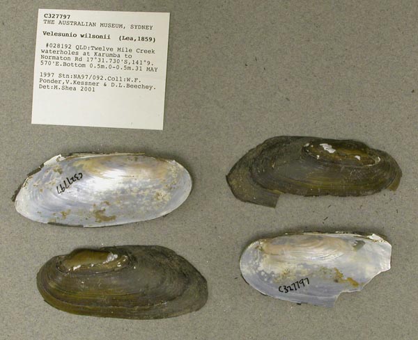
Twelve Mile Creek waterholes at Karumba to Normaton Rd, Queensland, Australia [-17.529, 141.159 ± 100 m]
| 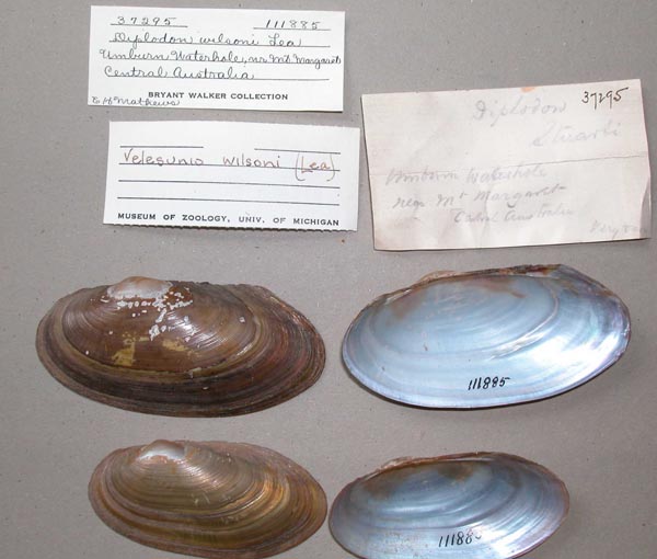
UMMZ_111885
Unknown waterhole, near Mt. Margaret, Central Australia
| 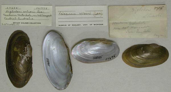
UMMZ_111885
Unknown waterhole, near Mt. Margaret, Central Australia
| 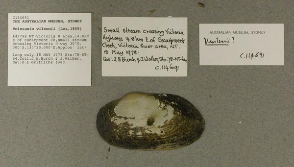
AMS_114691
Victoria R area, 14.8km E of Escarpment Ck, small stream crossing Victoria H'way, Northern Territory, Australia [-15.6, 130.333 ± 100 km]
| 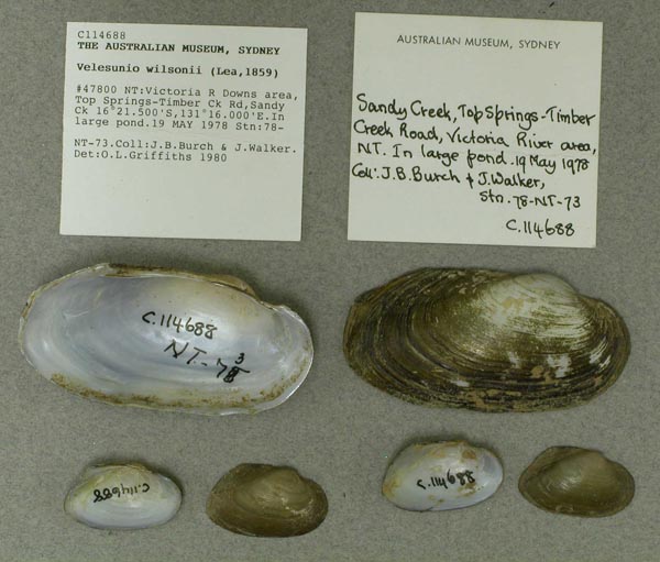
AMS_114688
Victoria R Downs area, Top Springs-Timber Ck Rd, Sandy Ck (In large pond), Northern Territory, Australia [-16.358, 131.267 ± 10 km]
| 
AMS_125942
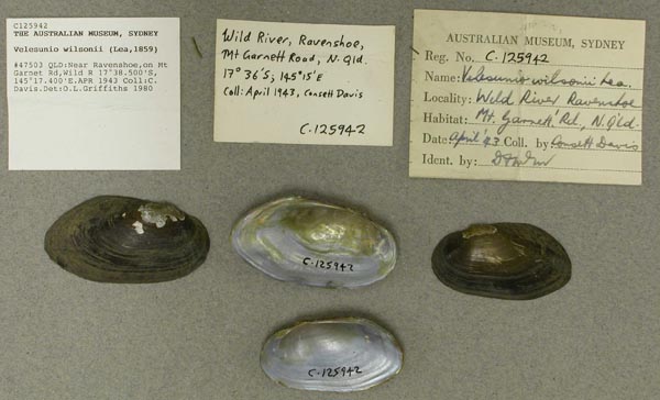
W Atherton Tableland, Wild River at Kennedy Hwy, Queensland, Australia [-17.642, 145.29 ± 1 km]
| 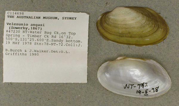
AMS_114698
Water Bag Ck, on Top Springs-Timber Ck Rd (Sandy bottom), Northern Territory, Australia [-16.542, 131.427 ± 1 km]
| 
AMS_327808
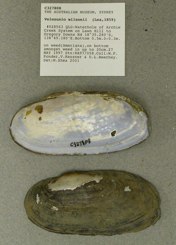
Waterhole of Archie Creek System on Lawn Hill to Gregory Downs Rd (on weed(Ameriana), on bottom amongst weed in up to 30cm), Queensland, Australia [-18.588, 138.82 ± 100 m]
| 
AMS_327798
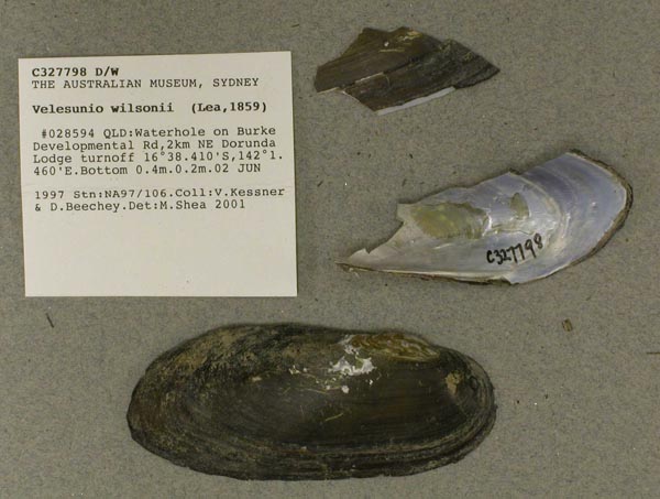
Waterhole on Burke Developmental Rd, 2km NE Dorunda Lodge turnoff, Queensland, Australia [-16.64, 142.024 ± 100 m]
| 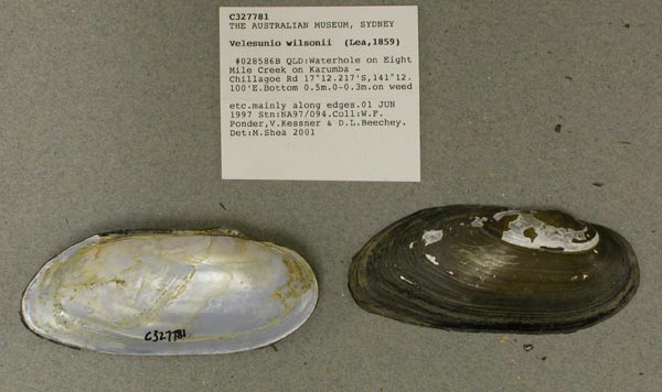
AMS_327781
Waterhole on Eight Mile Creek on Karumba - Chillagoe Rd (on weed etc. mainly along edges), Queensland, Australia [-17.204, 141.202 ± 10 km]
| 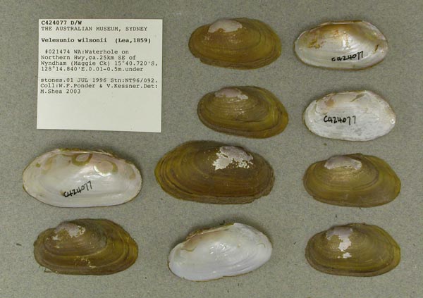
AMS_424077
Waterhole on Northern Hwy, ca. 25km SE of Wyndham (Maggie Ck) (under stones), Western Australia, Australia [-15.679, 128.247 ± 100 m]
| 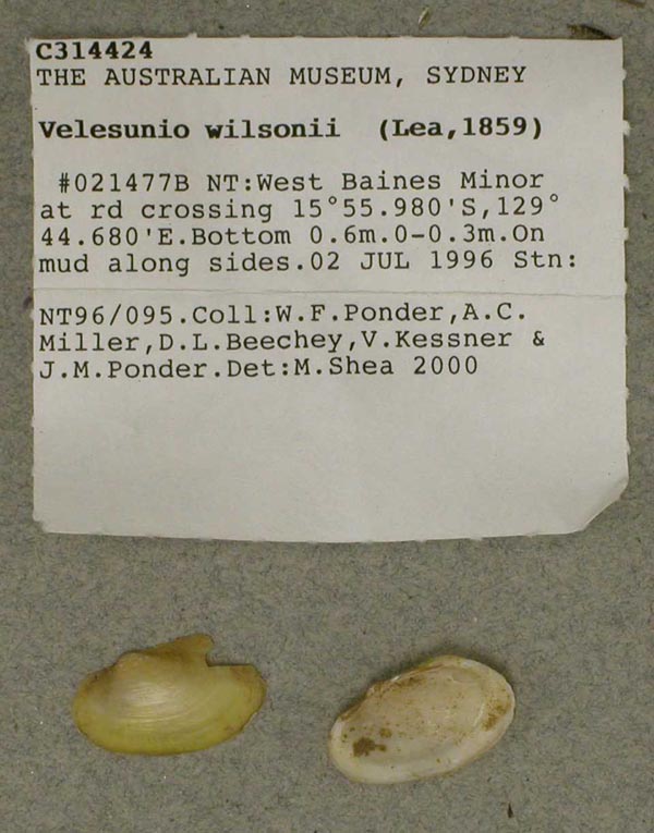
AMS_314424
West Baines Minor at rd crossing (On mud along sides), Northern Territory, Australia [-15.933, 129.745 ± 100 m]
| 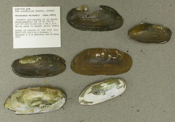
AMS_327774
Wyaaba Ck on Burke Developmental Rd (on sand in deeper pools where water is cooler), Queensland, Australia [-16.692, 141.951 ± 100 m]
|
AMS_421802. "The Springs" HS (Waterhole), Queensland, Australia [-22.182, 145.377 ± 100 m] AMS_385746. 177.8 km from Marlborough turnoff to inland road, unnamed swampy creek on Sarina - Marlborough Inland Rd (On edges of creek, in mud and on leaves etc.), Queensland, Australia [-21.848, 148.932 ± 100 m] AMS_327806. 2km downstream from waterhole behind Lawn Hill Stn homestead, Queensland, Australia [-18.567, 138.586 ± 100 m] AMS_427147. 43.5 km SE of Kununurra on Victoria Hwy (In small rocky, muddy pool in otherwise dry stream, under rocks, wood, bark etc.), Northern Territory, Australia [-15.986, 129.011 ± 100 m] AMS_61720. Alexandria Downs Station, Northern Territory, Australia [-19.05, 136.7 ± 10 km] AMS_314458. Anthonys Lagoon, at Anthony Lagoon Stn, off Tablelands Hwy (on mud and dead leaves etc. [N.essingtonensis - on wood & mud]), Northern Territory, Australia [-17.985, 135.539 ± 100 m] AMS_125923. Aramac, Queensland, Australia [-22.967, 145.25 ± 10 km] AMS_118187. Atherton Tableland, Innot Hot Springs, Queensland, Australia [-17.667, 145.25 ± 10 km] AMS_423844. Avon Downs, Northern Territory, Australia [-20.033, 137.483 ± 10 km] AMS_413029. Billabong 3.5km S of NA97/049 (on edges), Queensland, Australia [-18.331, 138.493 ± 100 m] AMS_338601. Billabong 3km from Nicholson R (on mud and weed), Queensland, Australia [-17.995, 138.842 ± 100 m] AMS_327786. Billabong at junction of Burketown and Camooweal Roads ca. 23km SW of Burketown, Queensland, Australia [-17.863, 139.351 ± 100 m] AMS_424078. Billabong at side of Delamere Rd, ca. 37km S of Victoria Hwy (muddy substrate), Northern Territory, Australia [-15.582, 131.653 ± 100 m] AMS_327769. Billabong on Burke Developmental Rd between Highbury and Dunbar, Queensland, Australia [-16.281, 142.995 ± 100 m] AMS_413031. Billabong on E side of Leichhardt River (on mud amongst weeds and on weeds), Queensland, Australia [-18.227, 139.898 ± 100 m] AMS_338607. Billabong W of Mt Oscar on Lawn Hill Stn, N of Lawn Hill Stn house (on mud along edges), Queensland, Australia [-18.292, 138.491 ± 100 m] AMS_386832. Boggy Creek, on Torrens Ck - Barcaldine Rd (small muddy pools), Queensland, Australia [-22.02, 145.183 ± 100 m] AMS_404105. Boggy Creek, on Torrens Ck - Barcaldine Rd (small muddy pools), Queensland, Australia [-22.02, 145.183 ± 100 m] AMS_424689. Bulloo R, Queensland, Australia [-28.55, 142.7 ± 100 km] AMS_327792. Calvert River crossing on Carpentaria Hwy (under stone in flowing water and in large pools on surface of Pandanus leaves, under roots, etc.), Northern Territory, Australia [-16.934, 137.361 ± 100 m] AMS_314476. Clay pan and river channel N of Moorabulla(?***) Waterhole, NNE of Bedourie (In river channel.), Queensland, Australia [-24.101, 139.552 ± 100 m] AMS_427148. Cockatoo Lagoon, Keep River NP, N of Victoria Hwy (On & under wood & rocks), Northern Territory, Australia [-15.971, 129.041 ± 100 m] AMS_314477. Creek on rd between Blackall and Isisford, 1/2km E of Hope Ck, nr turnoff to Athol Station (Pools in creek, mud, pebbles, filamentous green algae), Queensland, Australia [-24.489, 145.19 ± 100 m] AMS_338599. Dam beside Burke Developmental Rd (on mud around edges of dam), Queensland, Australia [-16.528, 143.941 ± 100 m] AMS_424076. Dam off side rd off Delamere Rd, ca. 35km S of Victoria Hwy (see data sheet), Northern Territory, Australia [-15.585, 131.653 ± 100 m] AMS_427155. Dingo Spring Ck, on Victoria Hwy (In pool, under stones), Northern Territory, Australia [-15.733, 130.559 ± 100 m] AMS_116772. Fitzroy R, 200m downstream from bridge at Willare Roadhouse crossing (In mud, shallow water), Western Australia, Australia [-17.733, 123.5 ± 1 km] AMS_401825. Garden Spring, Louie Ck, Lawn Hill NP, ca. 10km S of Adels Grove (on weed), Queensland, Australia [-18.777, 138.503 ± 100 m] AMS_405629. Herbert R, on Cashmere-Kirrama Rd (On sandy banks in quiet pools on sides of river), Queensland, Australia [-18.139, 145.338 ± 100 m] AMS_125866. Jericho, Queensland, Australia [-23.6, 146.133 ± 10 km] AMS_400909. Jordan R, at Jericho, on Capricorn Hwy (Alice R Drainage), Queensland, Australia [-23.599, 146.133 ± 100 m] AMS_327790. Judy Lagoon at Armraynald Stn Homestead on Burketown Normanton Rd (on weed and mud), Queensland, Australia [-17.957, 139.756 ± 100 m] AMS_125924. Julia Ck, Queensland, Australia [-20.667, 141.467 ± 100 km] AMS_327800. Karumba (Man-made pools behind town, common all through system), Queensland, Australia [-17.485, 140.84 ± 100 m] AMS_424079. Lake behind Diversion Dam, Kununurra (see data sheet), Western Australia, Australia [-15.792, 128.699 ± 100 m] AMS_421794. Lake Dunn, Queensland, Australia [-22.603, 145.674 ± 100 m] AMS_421795. Lake Dunn, Queensland, Australia [-22.603, 145.674 ± 100 m] AMS_421796. Lake Dunn, Queensland, Australia [-22.603, 145.674 ± 100 m] AMS_421797. Lake Dunn, Queensland, Australia [-22.603, 145.674 ± 100 m] AMS_421798. Lake Dunn, Queensland, Australia [-22.603, 145.674 ± 100 m] AMS_421799. Lake Dunn, Queensland, Australia [-22.603, 145.674 ± 100 m] AMS_421800. Lake Dunn, Queensland, Australia [-22.603, 145.674 ± 100 m] AMS_421801. Lake Dunn, Queensland, Australia [-22.603, 145.674 ± 100 m] AMS_125925. Lake Idamea, nr Glenormiston, 137km W of Boulia, Queensland, Australia [-22.917, 138.783 ± 10 km] AMS_405631. Lake Woods (isolated waterhole), Northern Territory, Australia [-17.633, 133.5 ± 1 km] AMS_164241. Lake Woods, S of Elliot, Northern Territory, Australia [-17.817, 133.55 ± 10 km] AMS_422333. Lake Woods, S of Newcastle Waters, Northern Territory, Australia [-17.733, 133.433 ± 10 km] AMS_126255. Leichhardt R at Kajabbi, Queensland, Australia [-20.033, 140.033 ± 10 km] AMS_327780. Little Archie Creek between Lawn Hill Stn Homestead and Gregory Downs (on roots (Gyraulus)), Queensland, Australia [-18.605, 138.69 ± 100 m] AMS_314502. Longreach Waterhole, Lake Woods (along edge of waterhole on firm sandy mud), Northern Territory, Australia [-17.616, 133.473 ± 100 m] AMS_405630. Magnetic Is, Horseshoe Bay (Freshwater swamp), Queensland, Australia [-19.113, 146.863 ± 1 km] AMS_354199. Mentana Creek, trib of Staaten R, 20m N of creek crossing, waterhole (mud, some sand and dead leaves), Queensland, Australia [-16.373, 142.116 ± 100 m] AMS_430728. Mitchell River at Mount Carbine, N of Mareeba, Queensland, Australia [-16.558, 145.087 ± 10 km] AMS_126460. Moulamen Water, near Upper Liveringa, Fitzroy Valley, Western Australia, Australia [-17.967, 124.317 ± 10 km] AMS_413030. Mudhole ca. 9.5km W of Borroloola on Carpentaria Hwy (on mud & weed), Northern Territory, Australia [-16.111, 136.223 ± 100 m] AMS_327767. mudholes (2) by Walker Creek (in fine mud around edges), Queensland, Australia [-17.467, 141.18 ± 100 m] AMS_404106. Mungkan Kandju NP, Archer Bend, Horsetrailer Waterhole (Sloping banks of large waterhole, on sand & leaves), Queensland, Australia [-13.41, 142.315 ± 100 m] AMS_421784. NE of Barcaldine, "Coreena" HS, spring in creek (Small dry creek channels), Queensland, Australia [-23.291, 145.412 ± 100 m] AMS_366289. Newcastle Ck, Stuart Highway, under middle bridge (Small pool, muddy bottom), Northern Territory, Australia [-17.262, 133.456 ± 100 m] AMS_366302. Newcastle Waters Station, unnamed lagoon (Waterhole, on dead leaves and grass & in water), Northern Territory, Australia [-17.277, 133.422 ± 100 m] AMS_371670. Newcastle Waters Station, unnamed lagoon (Waterhole, on dead leaves and grass & in water), Northern Territory, Australia [-17.277, 133.422 ± 100 m] AMS_371674. Newcastle Waters Station, unnamed lagoon (Waterhole, on dead leaves and grass & in water), Northern Territory, Australia [-17.277, 133.422 ± 100 m] AMS_366301. Newcastle Waters, causeway (Waterhole, much organic matter & floating weed), Northern Territory, Australia [-17.373, 133.412 ± 100 m] AMS_371677. Newcastle Waters, causeway (Waterhole, much organic matter & floating weed), Northern Territory, Australia [-17.373, 133.412 ± 100 m] AMS_420528. Nicholson River at Doomadgee (in pools in large river bed), Queensland, Australia [-17.961, 138.851 ± 100 m] AMS_338597. Nicholson River at Doomadgee (On side of river channel behind cow weir), Queensland, Australia [-17.961, 138.851 ± 100 m] AMS_371654. On rd to Geikie Gorge (Submerged on rocks & stones in pool), Western Australia, Australia [-18.161, 125.599 ± 100 m] AMS_430697. Oonoonba, near Townsville, Queensland, Australia [-19.3, 146.817 ± 10 km] AMS_386831. Prairie Creek, on Torrens Ck - Barcaldine Rd (Sandy creek bed), Queensland, Australia [-21.681, 145.152 ± 100 m] AMS_423040. Robinson R. at road crossing SE of Borroloola, W. Gulf of Carpentaria, Northern Territory, Australia [-16.473, 137.048 ± 100 m] AMS_427152. Skull Ck Minor, on Victoria Hwy (In grass alongside of creek), Northern Territory, Australia [-15.733, 130.751 ± 100 m] AMS_327773. Swamp between Four Mile Lagoon and Pioneer Waterhole (on weed and mud), Queensland, Australia [-17.291, 138.32 ± 100 m] AMS_422332. Townsville, Ross River, above second weir (In pools), Queensland, Australia [-19.267, 146.817 ± 10 km] AMS_430725. Townsville, Ross River, Queensland, Australia [-19.304, 146.781 ± 10 km] AMS_327787. trib. of Staaten River (Mud and leaves along edges), Queensland, Australia [-16.427, 142.083 ± 100 m] AMS_427157. unnamed ck 45km W of Lennard R crossing, on Gibb R Rd (On weeds & grass), Western Australia, Australia [-17.145, 125.053 ± 100 m] AMS_424691. W of Gladstone, Biloela, Callide Dam, on Dawson R system, Queensland, Australia [-24.4, 150.517 ± 10 km] AMS_327782. Waterhole 300m N of Gilbert R on Burke Developmental Rd (on mud & weed along edges), Queensland, Australia [-17.165, 141.769 ± 100 m] AMS_327799. Waterhole beside Burketown to Normanton Rd, Queensland, Australia [-18.138, 140.187 ± 100 m] AMS_424080. Waterhole in river flood channel of Gilbert R, ca. 0.2km S of Gilbert R (on weed & mud), Queensland, Australia [-17.174, 141.766 ± 100 m] AMS_413032. Waterhole on Dogwood Ck on Burke Developmental Rd (on weed & mud), Queensland, Australia [-16.862, 141.968 ± 100 m] AMS_327772. Waterhole on Dogwood Ck on Burke Developmental Rd (on weed & mud), Queensland, Australia [-16.862, 141.968 ± 100 m] AMS_327803. Waterhole on trib of Limestone Creek, nr road on E side (On leaves & rocks), Northern Territory, Australia [-15.873, 135.518 ± 100 m] AMS_427623. West Baines Minor, on Victoria Hwy (At water's edge & in water, crawling on mud), Northern Territory, Australia [-15.933, 129.744 ± 100 m] AMS_338606. Woods Lake, near Burketown (on edges), Queensland, Australia [-17.752, 139.476 ± 100 m] AMS_424690. Yeppen, near Rockhampton, Murray Lagoon, W of island, near deep waterhole, Queensland, Australia [-23.417, 150.5 ± 10 km]
Indonesia |