Bivalvia | Unionida | Unionoidea | Margaritiferidae | Margaritiferinae | Margaritifera
species Margaritifera middendorffi (Rosén, 1926): specimens
3 available nominal species synonyms (5 total synonyms)
Recent Taxonomic Opinions
Margaritifera togakushiensis — Graf (2007), Graf & Cummings (2007), Kondo (2008), Bogan (2010), Bolotov et al. (2015), Takeuchi et al. (2015), Sano et al. (2017), Zieritz et al. (2018), Sano et al. (2020)
Margaritifera middendorffi — Graf (2007), Graf & Cummings (2007), Bogan (2010), IUCN (2011), Bolotov et al. (2015), ... Graf & Cummings (2021), Wu et al. (2021), Jeratthitikul et al. (2022), Douda et al. (2024), Chen et al. (2025)
Margaritifera laevis — Araujo et al. (2009), Takeuchi et al. (2015)
Kurilinaia kamchatica — Kantor et al. (2010)
Kurilinaia middendorffi — Kantor et al. (2010)
Margaritifera (s.s.) middendorffi — Bolotov et al. (2016)
Dahurinaia middendorffi — Vinarski & Kantor (2016)
Dahurinaia kamchatica — Vinarski & Kantor (2016)
Margaritifera middendorffii — Vikhrev et al. (2018)
Margaritifera kurilensis — Bogatov (2022)
Margaritifera middendorffi middendorffi — Bogatov (2022)
Margaritifera middendorffi kamchatica — Bogatov (2022)
Range
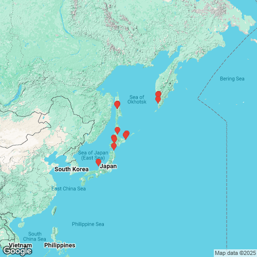
Southwestern and extreme southern Kamchatka, eastern Russia, south to Japan.
Map of Georeferenced Specimens

MUSSELp Specimen Records
Japan
|
|
|
|
NSMT-MO_73707. Sakasa River at Togakushi (136°6’ E, 36°45’ N, 1200 m altitude), Nagano Prefecture, Honshu, Japan
Russia
TYPE_LOCALITY_MP_011. Golygina River, Kamchatka Peninsula
Genbank Vouchers
Georeferenced Genbank Vouchers
Japan
IDEA_shell227. (28S: LC807079, go to Genbank) Japan: Aomori, Rokkasho village.
MHS_OMEB630. (28S: MT020824, COI: MT020708, go to Genbank) Moutsu River, Hokkaido, Japan (44.9143, 142.5843).
Russia
RMBH_biv_d0079_15. (COI: KJ161542, go to Genbank) Confluence of Adamka and Armudanka rivers (Tym’ drainage), Sakhalin Island, Russia (50°49’42” N, 142°33’18” E).
RMBH_biv_d0079_4. (18S: KJ943537, COI: KJ161540, go to Genbank) ditto.
RMBH_biv_d0079_7. (COI: KJ161541, go to Genbank) ditto.
RMBH_biv_d0044_14. (18S: KJ943536, COI: KJ161538, go to Genbank) Golovnina River, Kunashir Island, Kurile Islands, Russia (43°44’57” N, 145°30’25” E).
RMBH_biv_d0044_16. (COI: KJ161539, go to Genbank) ditto.
RMBH_biv_d0099_1. (18S: KJ943539, COI: KJ161546, go to Genbank) Nachilova River, Kamchatka Peninsula, Russia (52°53’06” N, 156°26’54” E).
RMBH_biv_d0099_8. (18S: KJ943541, COI: KJ161548, go to Genbank) ditto.
RMBH_biv_d0099_6. (16S: KJ943528, 18S: KT343726, 28S: KT343735, COI: KJ161547, H3: MH293552, go to Genbank) Russia: Far East, Kamchatka, Nachilova River (53.0439°N, 156.7096°E), Bolshaya Basin, Okhotsk Sea drainage.
RMBH_biv_d0036_25. (COI: KJ161536, go to Genbank) Sennaya River, Kunashir Island, Kurile Islands, Russia (43°44’56” N, 145°27’57” E).
RMBH_biv_d0036_26. (COI: KJ161537, go to Genbank) ditto.
RMBH_biv_d0022_18. (COI: KJ161534, go to Genbank) Serebryanka River, Kunashir Island, Kurile Islands, Russia (44°03’18” N, 145°51’15” E).
RMBH_biv_d0022_20. (COI: KJ161535, go to Genbank) ditto.
RMBH_biv_d0082_68. (COI: KJ161543, go to Genbank) Tym’ River, Sakhalin Island, Russia (50°54’45” N, 142°39’48” E).
RMBH_biv_d0082_81. (18S: KJ943538, COI: KJ161544, go to Genbank) ditto.
RMBH_biv_d0082_86. (COI: KJ161545, go to Genbank) ditto.
RMBH_biv_e0001_1. (COI: KJ161549, go to Genbank) Voskresenovka River (Tym’ drainage), Sakhalin Island, Russia (50°54’10” N, 142°39’04” E).


